Oxelösund
| Oxelösund | |
|---|---|
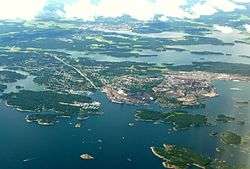 2012 aerial view of Oxelösund with Nyköping in the background | |
 Oxelösund  Oxelösund | |
| Coordinates: 58°40′N 17°07′E / 58.667°N 17.117°ECoordinates: 58°40′N 17°07′E / 58.667°N 17.117°E | |
| Country | Sweden |
| Province | Södermanland |
| County | Södermanland County |
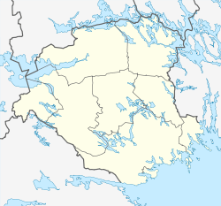
| Municipality | Oxelösund Municipality |
| Area[1] | |
| • Total | 11.57 km2 (4.47 sq mi) |
| Population (31 December 2010)[1] | |
| • Total | 10,870 |
| • Density | 939/km2 (2,430/sq mi) |
| Time zone | UTC+1 (CET) |
| • Summer (DST) | UTC+2 (CEST) |
Oxelösund is a locality and the seat of Oxelösund Municipality in Södermanland County, Sweden with 10,870 inhabitants in 2010.[1] It is located less than 15 kilometres (9.3 mi) south from the city centre of its larger neighbour Nyköping, with the two urban areas forming a wider agglomeration of nearly 50,000 people. Oxelösund literally translates as "Molar Isle Strait" into English, with the town being a harbour town bordering on an offshore archipelago, separated by narrow straits of water.
Climate
Oxelösund has a humid continental climate, with maritime influences which stem from its position at the head of a peninsula, with the weather station facing the open sea. In much of the urban area and up the peninsula the climate is somewhat more prone to swings, something intensifying farther north as in Nyköping.
| Climate data for Oxelösund (Femöre) (2002-2016; precipitation 1961–1990) | |||||||||||||
|---|---|---|---|---|---|---|---|---|---|---|---|---|---|
| Month | Jan | Feb | Mar | Apr | May | Jun | Jul | Aug | Sep | Oct | Nov | Dec | Year |
| Average high °C (°F) | 1.1 (34) |
1.6 (34.9) |
5.3 (41.5) |
10.3 (50.5) |
15.0 (59) |
19.4 (66.9) |
22.3 (72.1) |
21.4 (70.5) |
17.2 (63) |
10.7 (51.3) |
6.1 (43) |
3.1 (37.6) |
11.1 (52) |
| Daily mean °C (°F) | −1.1 (30) |
−0.8 (30.6) |
1.8 (35.2) |
6.3 (43.3) |
11.1 (52) |
15.4 (59.7) |
18.5 (65.3) |
17.8 (64) |
13.6 (56.5) |
8.0 (46.4) |
4.0 (39.2) |
0.9 (33.6) |
7.9 (46.2) |
| Average low °C (°F) | −3.3 (26.1) |
−3.2 (26.2) |
−1.7 (28.9) |
2.3 (36.1) |
7.2 (45) |
11.5 (52.7) |
14.8 (58.6) |
14.2 (57.6) |
10.1 (50.2) |
5.2 (41.4) |
1.8 (35.2) |
−1.3 (29.7) |
4.8 (40.6) |
| Average precipitation mm (inches) | 34.4 (1.354) |
25.7 (1.012) |
27.0 (1.063) |
28.7 (1.13) |
32.3 (1.272) |
42.6 (1.677) |
54.2 (2.134) |
55.5 (2.185) |
53.2 (2.094) |
45.4 (1.787) |
52.1 (2.051) |
40.1 (1.579) |
494.0 (19.449) |
| Source #1: SMHI[2] | |||||||||||||
| Source #2: SMHI Open Data[3] | |||||||||||||
Companies
•SSAB, Swedish steel.
History
The harbour at Oxelösund has been used for at least 500 years. In the 19th century, an increased extraction from the mining district of Central Sweden (e.g. Bergslagen), made Oxelösund a harbour of transport. A local railroad company was established in 1873, and bought virtually the entire peninsula which at the time belonged to the estates of the Stjärnholm Castle.
An iron works was constructed in 1913, and the community Oxelösund expanded, with the harbour, rail road and iron works being its cornerstones.
In 1950, the city was sufficiently developed to get the title of a city and was one of the last towns to receive city status in Sweden. Since 1971 this status is obsolete, but Oxelösund is the seat of a municipality with the same territory, one of the smallest in the country.
In November 2011, Oxelösund hosted the Nordic Under-21 Championships in underwater rugby.
Femöre battery is located near the area.
References
- 1 2 3 "Tätorternas landareal, folkmängd och invånare per km2 2005 och 2010" (in Swedish). Statistics Sweden. 14 December 2011. Archived from the original on 10 January 2012. Retrieved 10 January 2012.
- ↑ "Precipitation Normals 1961-1990 (Swedish)" (in Swedish). Swedish Metereological and Hydrological Institute (Oxelösund code 8740).
- ↑ "SMHI Öppna Data" (in Swedish). SMHI. 14 June 2017.
External links
![]()
![]()
European Union: Members of the town twinning "Douzelage" | ||
|---|---|---|
| Current members | ||
| Former members |
| |