Karmøy
| Karmøy kommune | |||
|---|---|---|---|
| Municipality | |||
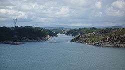 View of the Låvesundet | |||
| |||
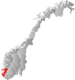
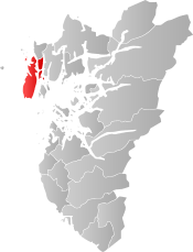 Karmøy within Rogaland | |||
| Coordinates: 59°15′23″N 05°14′57″E / 59.25639°N 5.24917°ECoordinates: 59°15′23″N 05°14′57″E / 59.25639°N 5.24917°E | |||
| Country | Norway | ||
| County | Rogaland | ||
| District | Haugaland | ||
| Administrative centre | Kopervik | ||
| Government | |||
| • Mayor (2015) | Jarle Nilsen (Ap) | ||
| Area | |||
| • Total | 229.95 km2 (88.78 sq mi) | ||
| • Land | 219.53 km2 (84.76 sq mi) | ||
| • Water | 10.42 km2 (4.02 sq mi) | ||
| Area rank | #315 in Norway | ||
| Population (2017) | |||
| • Total | 42,229 | ||
| • Rank | #21 in Norway | ||
| • Density | 192.4/km2 (498/sq mi) | ||
| • Change (10 years) | 10.1% | ||
| Demonym(s) |
Karmøybu Kartabu[1] | ||
| Time zone | UTC+01:00 (CET) | ||
| • Summer (DST) | UTC+02:00 (CEST) | ||
| ISO 3166 code | NO-1149 | ||
| Official language form | Norsk | ||
| Website |
www | ||
Karmøy is a municipality in Rogaland county, Norway. It is southwest of the city of Haugesund in the traditional district of Haugaland. The administrative centre of the municipality is the town of Kopervik.
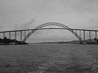
Most of the municipality lies on the island of Karmøy. The island is connected to the mainland by the Karmøy Tunnel and the Karmsund Bridge. It is known for its industries, as well as for fishing. Karmøy is also well known in Norway for its beautiful heather moors and the white sand surfing beaches.
The 230-square-kilometre (89 sq mi) municipality is the 315th largest by area out of the 422 municipalities in Norway. Karmøy is the 21st most populous municipality in Norway with a population of 42,229, making it one of the largest in the region. The municipality's population density is 192.4 inhabitants per square kilometre (498/sq mi) and its population has increased by 10.1% over the last decade.[2]
General information
The municipality of Karmøy is a recent creation. During the 1960s, there were many municipal mergers across Norway due to the work of the Schei Committee. On 1 January 1965, Karmøy municipality was created upon the merger of two towns and parts of five municipalities into one large municipality with 23,217 residents. The areas that were merged were:[3]
- the town of Kopervik (population: 1,737)
- the town of Skudeneshavn (population: 1,275)
- the whole municipality of Skudenes (population: 3,583)
- the whole municipality of Stangaland (population: 2,678)
- the whole municipality of Åkra (population: 6,008)
- all of Avaldsnes municipality west of the Førresfjorden (population: 4,153)
- most of the municipality of Torvastad (population: 3,783), except for the island of Vibrandsøy which went to Haugesund
Name
The municipality was named after the island of Karmøy, on which the majority of the municipality is located. The Old Norse form of the name was Kǫrmt. The name is probably derived from karmr which means "bargeboard" (here in the sense "the sheltering island"). The last element in the word, øy, means "island" and was added later.[4]
Coat-of-arms
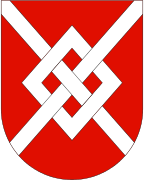
The coat-of-arms is from modern times; they were granted on 18 April 1975. The arms are a silver or white diamond interwoven with a cross on a red background. The diamond symbolizes the name Karmøy since the island protects the mainland. The cross symbolizes the historic Avaldsnes Church which was a royal chapel in the Middle Ages.[5]
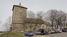
Churches
The Church of Norway has eight parishes (sokn) within the municipality of Karmøy. It is part of the Karmøy deanery in the Diocese of Stavanger.
| Parish (Sokn) | Church Name | Location of the Church | Year Built |
|---|---|---|---|
| Avaldsnes | Avaldsnes Church | Avaldsnes | 1250 |
| Falnes | Falnes Church | Skudeneshavn | 1851 |
| Ferkingstad | Ferkingstad Church | Ferkingstad | 1854 |
| Kopervik | Kopervik Church | Kopervik | c. 2017 |
| Norheim | Norheim Church | Norheim | 1978 |
| Torvastad | Torvastad Church | Torvastad | 1880 |
| Vedavågen | Vedavågen Church | Veavågen | 2009 |
| Åkra | Åkra Church | Åkrahamn | 1985 |
| Old Åkra Church | Åkrahamn | 1821 |
History
There are several finds from the Stone Age, Bronze Age and Iron Age. Large burial mounds, stone monuments, and many other ancient monuments are found on the island. Karmøy is the site of the Storhaug, Grønhaug, and Flagghaugen burial mounds.[6]
Karmøy was known for sailing in the old times. The eddic poem Grímnismál says that Thor, the weather god, wades the Karmsundet strait every morning on his way to Yggdrasil, the tree of life. The ocean outside Karmøy is dangerous, filled with underwater currents and rocks. Thus the ships were forced into the narrow Karmsundet. Chieftains and kings controlled the ships passing up and down the coast and demanded taxes.
The Karmsundet strait was also the source of the name of the kingdom, at the time when the first king of the unified Norway, Harald Fairhair, lived on Karmøy. (See History of Norway.)
Avaldsnes is located on the northeastern coast of the island. King Augvald who has given his name to this ancient site is mentioned in the Old Norse sagas as having his home here. Later the residence of Harald Fairhair and other kings are mentioned. There is also a medieval church, St. Olav's church of Avaldsnes, located on this coast.
Visnes, a village in the northwest of Karmøy was once the site of an important copper mine. This mine was source of the copper used for the Statue of Liberty in New York City.[7]
In the 18th century, two girls from Uyea in Shetland rowed to Haaf Gruney to milk some of the cows grazing there. Unfortunately, their return was marred by a strong storm, and eventually they found their tiny boat blown to Karmøy. The Uyea girls ended up marrying Karmøy men, and their descendants still live there. The Dyrland family of Karmoy are believed to be the family that the two girls married into after they arrived on Karmoy. Sivert Dyrland was a member of the Norwegian government in the early 20th century.[8]
Geography
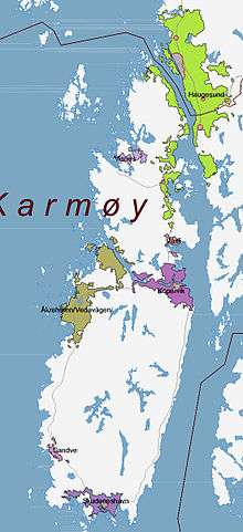
The majority of the municipality is located on the large island of Karmøy, but it also includes the mainland peninsula between the Karmsundet strait and Førresfjorden, plus the island of Feøy and several other small islands.
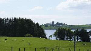
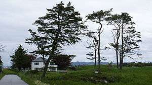
The natural and cultural landscape is highly heterogeneous, encompassing chalk-white sands, moorland, and several piers around the island. The landscape in the north is mainly agricultural, while large parts of the inland south are heather moors. The island has many white, sandy beaches facing the North Sea, attracting surfers as one of the top spots for windsurfing in Norway.
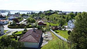
Towns and villages are mostly located along the coast. The three towns in Karmøy are all on the island, the administrative center Kopervik is on the east side, Åkrehamn is on the west side, while Skudeneshavn is on the southern tip. On the mainland part of Karmøy, the village of Norheim is contiguous with the neighboring town of Haugesund. To the south of Norheim is the village of Vormedal while the village of Kolnes is in the northeastern part of mainland Karmøy. Other villages in Karmøy include Avaldsnes, Eike, Ferkingstad, Sævelandsvik, Sandve, Veavågen, and Visnes.
Haugesund Airport is also located on the island rather than in the town of Haugesund proper. The Geitungen Lighthouse lies at the southern end of the municipality, marking the entrance to the Boknafjorden.
Government
All municipalities in Norway, including Karmøy, are responsible for primary education (through 10th grade), outpatient health services, senior citizen services, unemployment and other social services, zoning, economic development, and municipal roads. The municipality is governed by a municipal council of elected representatives, which in turn elect a mayor.
Municipal council
The municipal council (Kommunestyre) of Karmøyis made up of 17 representatives that are elected to four year terms. Currently, the party breakdown is as follows:[9][10]
| Party Name | Name in Norwegian | Number of representatives | |
|---|---|---|---|
| Labour Party | Arbeiderpartiet | 15 | |
| Progress Party | Framstegspartiet | 9 | |
| Conservative Party | Høgre | 8 | |
| Christian Party | De Kristne | 1 | |
| Christian Democratic Party | Kristelig Folkeparti | 7 | |
| Green Party | Miljøpartiet Dei Grøne | 1 | |
| Centre Party | Senterpartiet | 2 | |
| Socialist Left Party | Sosialistisk Venstreparti | 1 | |
| Liberal Party | Venstre | 1 | |
| Total number of members: | 45 | ||
Area attractions
- Skude Festival (Skudefestivalen) is an annual festival held during the first week of July in Skudeneshavn. It is the largest gathering of coastal culture in Western Norway with boats of all categories: vintage boats of all categories – old wooden boats, vintage boats, modern boats, sailing boats, tall ships. Craftsmen demonstrate handcrafts from olden days connected to sea and shipping. International and national artists entertain in the evenings. In 2004, Skudeneshavn was voted Norway's summer city by national TV viewers.[11]
- Viking Farm (Vikinggarden) is part of the Nordvegen History Centre, located close to Avaldsnes. The building and use of the farm is an ongoing experimental archaeological research and interpretation programme. The farm includes reconstructed houses.[12]
- Karmøy Museum of Fishing (Karmøy Fiskerimuseum), which opened in 1999, presents the history of fishing in the region of Karmøy from the 1950s up to the present day. In addition to the main exhibitions there are salt-water aquariums showing the most common types of fish in the area. The Karmøy Fishery Museum is housed in a new building with unique architecture.[13]
- Mælandsgården Museum (Museet i Mælandsgården) is situated in the middle of the old, well preserved part of Skudeneshavn. A town model shows what old Skudeneshavn looked like in 1918.[14]
- Rogaland Fish Museum (Rogaland Fiskerimuseum), located in an old herring salting factory in Åkrehamn, is fully restored to its former glory and housing new exhibitions about the history of this vibrant coastal community. This museum also richly depicts the contact enjoyed between Karmøy and North America.[15]
- Visnes Mining Museum (Visnes Gruvemuseum) provides the history of the rather special mining community that in the 1800s had 3,000 inhabitants. Visnes supplied the copper for the Statue of Liberty in New York City.[16]
- Ferkingstad, an area known for its archaeological finds, from the early Viking period to the late medieval era.
Industry
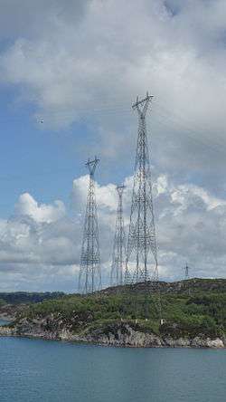
Norsk Hydro is a large aluminium smelter operator located on the island of Karmøy. The power supply of this facility is done by three overhead power lines, which cross the Karmsundet strait on 143.5-metre (471 ft) tall pylons. These pylons are the tallest electricity pylons in Norway.
Bauer-Nilsen design and produce high-pressure hydraulics located at Karmøy.
International relations
Twin towns – Sister cities
Karmøy has sister city agreements with the following places:
Notable residents
- Leif Ove Andsnes (born 1970), a Norwegian pianist and chamber musician
- King Augvald (7th century AD), a semi-legendary King in Norway
- Endre Johannes Cleven (1874—1916), a Norwegian-born Canadian who was prominent in the settlement and culture of Norwegian immigrants in Manitoba
- King Harald Fairhair (c. 850—c. 932), the first king of a united Norway
- King Ferking (7th century AD), a semi-legendary King in Norway
- Karin Moe (born 1945), a Norwegian writer and literary critic
References
- ↑ "Navn på steder og personer: Innbyggjarnamn" (in Norwegian). Språkrådet. Retrieved 2015-12-01.
- ↑ Statistisk sentralbyrå (2017). "Table: 06913: Population 1 January and population changes during the calendar year (M)" (in Norwegian). Retrieved 2017-11-01.
- ↑ Jukvam, Dag (1999). "Historisk oversikt over endringer i kommune- og fylkesinndelingen" (PDF) (in Norwegian). Statistisk sentralbyrå.
- ↑ Store norske leksikon. "Karmøy – kommune" (in Norwegian). Retrieved 2015-12-01.
- ↑ "Civic heraldry of Norway - Norske Kommunevåpen". Heraldry of the World. Retrieved 2015-12-01.
- ↑ "Gravhaugane på Reheiå". Skilta fornminner i Rogaland. Retrieved 2015-12-01.
- ↑ "Statue of Liberty". Visnes Copper Museum.
- ↑ Haswell-Smith, Hamish (2004). The Scottish Islands. Edinburgh: Canongate.
- ↑ "Table: 04813: Members of the local councils, by party/electoral list at the Municipal Council election (M)" (in Norwegian). Statistics Norway. 2015.
- ↑ "Kommunestyremedlemmene 2015-2019" (in Norwegian). Statistics Norway. 2015.
- ↑ "Skudefestival". Whatsonwhen Limited. Archived from the original on 2011-09-30.
- ↑ "Nordvegen History Centre". VisitNorway.com.
- ↑ "Karmøy Fiskerimuseum". VisitHaugesund.no. Archived from the original on 2011-07-23.
- ↑ "Museet i Mælandsgården". VisitHaugesund.no.
- ↑ "Åkrehamn Coast Museum". VisitHaugesund.no.
- ↑ "Visnes Mining Museum". VisitHaugesund.no.
- ↑ "Hankasalmen elinkeino- ja työllisyyspoliittinen ohjelma" (PDF) (in Finnish). Hankasalmi Municipality. Archived from the original (PDF) on 4 March 2016. Retrieved 7 May 2012.
External links
| Wikimedia Commons has media related to Karmøy. |
| Look up Karmøy in Wiktionary, the free dictionary. |
- Municipal fact sheet from Statistics Norway (in Norwegian)

- Tourist information – from the municipality (in English)
- Karmøy Museum of Fishing
- Mælandsgården
- Karmøy Kulturopplevelser
- Nordvegen History Center