Finnøy
| Finnøy kommune | |||
|---|---|---|---|
| Municipality | |||
 View of the shorelines of Ombo in Finnøy | |||
| |||
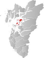 Finnøy within Rogaland | |||
| Coordinates: 59°09′53″N 05°49′46″E / 59.16472°N 5.82944°ECoordinates: 59°09′53″N 05°49′46″E / 59.16472°N 5.82944°E | |||
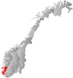
| Country | Norway | ||
| County | Rogaland | ||
| District | Ryfylke | ||
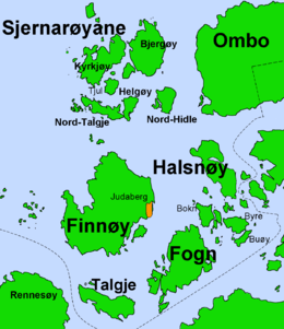
| Administrative centre | Judaberg | ||
| Government | |||
| • Mayor (2015) | Henrik Halleland (KrF) | ||
| Area | |||
| • Total | 104.39 km2 (40.31 sq mi) | ||
| • Land | 102.90 km2 (39.73 sq mi) | ||
| • Water | 1.49 km2 (0.58 sq mi) | ||
| Area rank | #375 in Norway | ||
| Population (2017) | |||
| • Total | 3,235 | ||
| • Rank | #256 in Norway | ||
| • Density | 31.4/km2 (81/sq mi) | ||
| • Change (10 years) | 21.1% | ||
| Demonym(s) | Finnøybu[1] | ||
| Time zone | UTC+01:00 (CET) | ||
| • Summer (DST) | UTC+02:00 (CEST) | ||
| ISO 3166 code | NO-1141 | ||
| Official language form | Nynorsk | ||
| Website |
www | ||

Finnøy is an island municipality in Rogaland county, Norway. It is located in the traditional district of Ryfylke. The administrative centre of the municipality is the village of Judaberg.
The municipality consists of a number of islands on the south side of the Boknafjorden, about 24 kilometres (15 mi) northeast of the city of Stavanger. The Finnøy Tunnel connects the two islands of Finnøy and Talgje to the mainland. The rest of the islands are accessible only by boat.
Finnøy is an agricultural community dominated by dairy, meat, poultry, and fish farming products, with strong horticultural traditions, mainly greenhouse production of tomatoes, as well as some tourism.
The 104-square-kilometre (40 sq mi) municipality is the 375th largest by area out of the 422 municipalities in Norway. Finnøy is the 256th most populous municipality in Norway with a population of 3,235. The municipality's population density is 31.4 inhabitants per square kilometre (81/sq mi) and its population has increased by 21.1% over the last decade.[2]
General information
The parish of Finnø was established as a municipality on 1 January 1838 (see formannskapsdistrikt). It originally encompassed the islands of Finnøy, Talgje, and Fogn as well as the small surrounding islets and the southeastern-most corner of the island of Rennesøy. On 1 January 1918, the part of Finnøy located on the island of Rennesøy (population: 72) was transferred from Finnøy to the neighboring municipality of Rennesøy.
During the 1960s, there were many municipal mergers across Norway due to the work of the Schei Committee. On 1 January 1965, the municipality of Finnøy was enlarged when it was merged with the entire municipality of Sjernarøy (population: 819), the northeastern part of Ombo island (population: 89) from the municipality of Jelsa, and the Fisterøyene islands (population: 246) from the municipality of Fister.[3]
On 1 January 2020, the municipalities of Finnøy, Rennesøy, and Stavanger are scheduled to merge into one, large municipality called Stavanger.[4]
Name
The municipality is named after the island of Finnøy (Old Norse: Finnøy). The meaning of the first element is unknown and the last element is øy which means "island." Before 1918, the name was written "Finnø."[5]
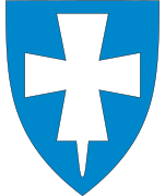
Coat-of-arms
The coat-of-arms is from modern times; they were granted on 23 September 1983. Despite its recent adoption, it has old roots. The arms show a silver or white wing on a blue background. The arms were derived from the arms of the Hestbø family (which included Ogmund Finnsson), one of the mightiest families in the area in the 14th century. They had their stronghold on their Hesby estate on the island of Finnøy in the present municipality.[6]
Churches
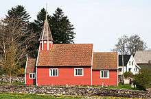
The Church of Norway has three parishes (sokn) within the municipality of Finnøy. It is part of the Tungenes deanery in the Diocese of Stavanger.
| Parish (Sokn) | Church Name | Location of the Church | Year Built |
|---|---|---|---|
| Hesby | Hesby Church | Hesby on Finnøy | c. 1100 |
| Sjernarøy | Sjernarøy Church | Kyrkjøy in Sjernarøyane islands | 1647 |
| Jørstad Church | Jørstadvågen on Ombo | 1929 | |
| Talgje | Fogn Church | Fogn | 1991 |
| Talgje Church | Talgje | c. 1100 |
History
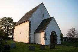
Finnøy was at the top of its power in the middle of the fourteenth century when the King's representative Ogmund Finnsson had his seat at Hesby on the west side of the island of Finnøy. The medieval, stone Hesby Church, dating back to at least the thirteenth century, still stands at Hesby.


It is often claimed that the Norwegian mathematician Niels Henrik Abel (1802–1829) was born on Finnøy, since his father Søren Georg acted as rector there. Recent studies indicates, however, that he was born in Nedstrand, a nearby parish. However, he was raised on Finnøy.
Geography
The island municipality of Finnøy is located on the south side of the Boknafjorden. The main islands of Finnøy include Finnøy, Talgje, Fogn, Halsnøya, Sjernarøyane, and the north and west parts of the island of Ombo. The islands of Talgje and Finnøy are connected to the mainland by the undersea Finnøy Tunnel. The rest of the islands are only accessible by boats.
Government
All municipalities in Norway, including Finnøy, are responsible for primary education (through 10th grade), outpatient health services, senior citizen services, unemployment and other social services, zoning, economic development, and municipal roads. The municipality is governed by a municipal council of elected representatives, which in turn elect a mayor.
Municipal council
The municipal council (Kommunestyre) of Finnøy is made up of 21 representatives that are elected to four year terms. Currently, the party breakdown is as follows:[7]
| Party Name | Name in Norwegian | Number of representatives | |
|---|---|---|---|
| Labour Party | Arbeiderpartiet | 2 | |
| Conservative Party | Høgre | 4 | |
| Christian Democratic Party | Kristelig Folkeparti | 6 | |
| Centre Party | Senterpartiet | 4 | |
| Liberal Party | Venstre | 5 | |
| Total number of members: | 21 | ||
References
- ↑ "Navn på steder og personer: Innbyggjarnamn" (in Norwegian). Språkrådet. Retrieved 2015-12-01.
- ↑ Statistisk sentralbyrå (2017). "Table: 06913: Population 1 January and population changes during the calendar year (M)" (in Norwegian). Retrieved 2017-11-04.
- ↑ Jukvam, Dag (1999). "Historisk oversikt over endringer i kommune- og fylkesinndelingen" (PDF) (in Norwegian). Statistisk sentralbyrå.
- ↑ "Om nye Stavanger" (in Norwegian). Retrieved 2017-11-04.
- ↑ Rygh, Oluf (1915). Norske gaardnavne: Stavanger amt (in Norwegian) (10 ed.). Kristiania, Norge: W. C. Fabritius & sønners bogtrikkeri. p. 245.
- ↑ "Civic heraldry of Norway - Norske Kommunevåpen". Heraldry of the World. Missing or empty
|url=(help);|access-date=requires|url=(help) - ↑ "Table: 04813: Members of the local councils, by party/electoral list at the Municipal Council election (M)" (in Norwegian). Statistics Norway. 2015.
External links


- Municipal fact sheet from Statistics Norway (in Norwegian)