Forsand
| Forsand kommune | |||
|---|---|---|---|
| Municipality | |||
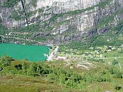 Lysebotn, located at the head of the Lysefjorden | |||
| |||
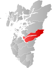 Forsand within Rogaland | |||
| Coordinates: 59°00′49″N 06°25′28″E / 59.01361°N 6.42444°ECoordinates: 59°00′49″N 06°25′28″E / 59.01361°N 6.42444°E | |||
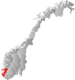
| Country | Norway | ||
| County | Rogaland | ||
| District | Ryfylke | ||
| Administrative centre | Forsand | ||
| Government | |||
| • Mayor (2015) | Bjarte Sveinsvoll Dagestad (H) | ||
| Area | |||
| • Total | 780.06 km2 (301.18 sq mi) | ||
| • Land | 698.83 km2 (269.82 sq mi) | ||
| • Water | 81.23 km2 (31.36 sq mi) | ||
| Area rank | #141 in Norway | ||
| Population (2017) | |||
| • Total | 1,245 | ||
| • Rank | #376 in Norway | ||
| • Density | 1.8/km2 (5/sq mi) | ||
| • Change (10 years) | 12.9% | ||
| Demonym(s) | Forsandbu[1] | ||
| Time zone | UTC+01:00 (CET) | ||
| • Summer (DST) | UTC+02:00 (CEST) | ||
| ISO 3166 code | NO-1129 | ||
| Official language form | Nynorsk | ||
| Website |
www | ||

Forsand is a municipality in Rogaland county, Norway. It is located in the traditional district of Ryfylke. The administrative centre of the municipality is the village of Forsand. Other villages in the municipality include Lysebotn, Øvre Espedal, Oanes, Kolabygda, and Fløyrli.
Forsand municipality surrounds the famous Lysefjorden and it lies on the east side of the Høgsfjorden. In 1999, evidence of a population here dating back to around 7500 BC was located.
It is one of largest municipalities within the county of Rogaland in terms of area, and one of the smallest in terms of population. The 780-square-kilometre (300 sq mi) municipality is the 141st largest by area out of the 422 municipalities in Norway. Forsand is the 376th most populous municipality in Norway with a population of 1,245. The municipality's population density is 1.8 inhabitants per square kilometre (4.7/sq mi) and its population has increased by 12.9% over the last decade.[2]
General information


The municipality of Fossan was established on 1 January 1871 when the very large municipality of Høgsfjord was divided into two: Fossan (located east of the Høgsfjorden and south of the Frafjorden) and Høle (located west of the Høgsfjorden). Initially, Fossan had 2,081 residents. During the 1960s, there were many municipal mergers across Norway due to the work of the Schei Committee. On 1 January 1965, the municipality was split, with everything located south and east of the Frafjorden being transferred to the neighboring municipality of Gjesdal. This area had no road connection with the rest of Forsand, but it was connected by road to Gjesdal.[3]
On 1 January 2020, the neighboring municipalities of Sandnes and Forsand are scheduled to merge into one large municipality called Sandnes.[4]
Name
The municipality (originally the parish) is named after the old Forsand farm (Old Norse: Forsandr), since the first Forsand Church was built there. The first element is the prefix for which means "outsticking" and the last element is sandr which means "sand" or "sandy beach". Before 1918, the name was written "Fossan".[5]
Coat-of-arms
The coat-of-arms is from modern times. They were granted on 11 March 1988. The arms show a white heron on a green background. They were designed by John Digernes to represent a common bird in the area.[6]
Churches
The Church of Norway has one parish (sokn) within the municipality of Forsand. It is part of the Ryfylke deanery in the Diocese of Stavanger.
| Parish (Sokn) | Church Name | Location of the Church | Year Built |
|---|---|---|---|
| Forsand | Forsand Church | Forsand | 1854 |
| Lyse Chapel | Lysebotn | 1961 |
Geography
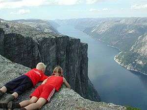
Forsand is a large municipality that is very mountainous with a long, narrow fjord running through the middle from east to west. The Lysefjorden is surrounded by very steep 1,000-metre (3,300 ft) tall cliffs such as Kjerag and Preikestolen, with the Lysefjord Bridge crossing the fjord near the western end. The famous Kjeragbolten boulder and Kjeragfossen waterfall are located along the inner part of the fjord. The village of Lysebotn lies at the eastern end of the fjord. The lake Nilsebuvatnet is located high up in the mountains, north of Lysebotn on the border of Strand and Forsand municipalities. It is regulated for hydroelectric power use at the Lysebotn Hydroelectric Power Station.

Government
All municipalities in Norway, including Forsand, are responsible for primary education (through 10th grade), outpatient health services, senior citizen services, unemployment and other social services, zoning, economic development, and municipal roads. The municipality is governed by a municipal council of elected representatives, which in turn elect a mayor.
Municipal council
The municipal council (Kommunestyre) of Forsand is made up of 17 representatives that are elected to four year terms. Currently, the party breakdown is as follows:[7]
| Party Name | Name in Norwegian | Number of representatives | |
|---|---|---|---|
| Labour Party | Arbeiderpartiet | 2 | |
| Conservative Party | Høgre | 3 | |
| Christian Democratic Party | Kristelig Folkeparti | 4 | |
| Centre Party | Senterpartiet | 3 | |
| Local Lists | Lokale lister | 5 | |
| Total number of members: | 17 | ||
References
- ↑ "Navn på steder og personer: Innbyggjarnamn" (in Norwegian). Språkrådet. Retrieved 2015-12-01.
- ↑ Statistisk sentralbyrå (2017). "Table: 06913: Population 1 January and population changes during the calendar year (M)" (in Norwegian). Retrieved 2017-11-04.
- ↑ Jukvam, Dag (1999). "Historisk oversikt over endringer i kommune- og fylkesinndelingen" (PDF) (in Norwegian). Statistisk sentralbyrå.
- ↑ "Kommunereformen" (in Norwegian). Forsand kommune. Retrieved 2017-11-04.
- ↑ Rygh, Oluf (1915). Norske gaardnavne: Stavanger amt (in Norwegian) (10 ed.). Kristiania, Norge: W. C. Fabritius & sønners bogtrikkeri. pp. 220–225.
- ↑ "Civic heraldry of Norway - Norske Kommunevåpen". Heraldry of the World. Retrieved 2016-02-25.
- ↑ "Table: 04813: Members of the local councils, by party/electoral list at the Municipal Council election (M)" (in Norwegian). Statistics Norway. 2015.
External links
| Wikimedia Commons has media related to Forsand. |


- Municipal fact sheet from Statistics Norway (in Norwegian)
- Ryfylke visitors website
- Live web camera from Lysefjord, Forsand