Utsira (island)
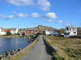 View of the island | |
 Location in northern Rogaland county | |
| Geography | |
|---|---|
| Location | Rogaland, Norway |
| Coordinates | 59°18′29″N 4°53′18″E / 59.3081°N 4.8884°ECoordinates: 59°18′29″N 4°53′18″E / 59.3081°N 4.8884°E |
| Area | 5.9 km2 (2.3 sq mi) |
| Length | 2.9 km (1.8 mi) |
| Width | 3.4 km (2.11 mi) |
| Coastline | 13 km (8.1 mi) |
| Highest elevation | 71 m (233 ft) |
| Highest point | Araseto |
| Administration | |
| County | Rogaland |
| Municipality | Utsira |
Utsira is an island in Rogaland county, Norway. Utsira Church and Utsira Lighthouse are located on the island.
The 5.9-square-kilometre (2.3 sq mi; 1,500-acre) island makes up almost all of Utsira municipality. The island lies about 18 kilometres (11 mi) west of the island of Karmøy, with the Sirafjorden lying between the two islands. The island is only connected to the mainland by ferry. There are four regular ferry routes connecting the island to the town of Haugesund each day. The ferries are operated by Rutebåten Utsira.[1]
Most of the island's population lives in the central valley that runs north-south on the island. There are about 200 residents of the island.[1]
Utsira is known as the best birding site in Norway. There have been 317 different species recorded on Utsira.[2]
It gives its name to the Shipping Forecast areas of North and South Utsire (the spelling Utsire was used between 1875–1924).
See also
References
- 1 2 Store norske leksikon. "Utsira" (in Norwegian). Retrieved 2015-10-19.
- ↑ "Utsira - et eldorado for fugletittere" (in Norwegian). VisitHaugesund.no. Retrieved 2015-10-19.