U.S. Route 311
| |||||||
|---|---|---|---|---|---|---|---|
 | |||||||
| Route information | |||||||
| Length | 102.3 mi[1] (164.6 km) | ||||||
| Existed | 1927–present | ||||||
| Major junctions | |||||||
| South end |
| ||||||
| |||||||
| North end |
| ||||||
| Location | |||||||
| States | North Carolina, Virginia | ||||||
| Counties |
NC: Randolph, Guilford, Forsyth, Stokes, Rockingham VA: Pittsylvania | ||||||
| Highway system | |||||||
| |||||||

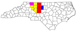
U.S. Route 311 is a United States highway that runs for 102.3 mi (164.6 km) from Randleman, North Carolina to near Danville, Virginia. Along the route, it connects the cities of High Point, Winston-Salem, Madison, and Eden. The route can be considered an alternate route of US 220, which provides a more direct route.
Route description


US 311 begins at the I-73/US 220 interchange in Randleman. Heading northwest, it connects with Interstate 74, at Cedar Square Road. In concurrency with Interstate 74, it bypasses north of High Point before heading west towards Winston-Salem. In Winston-Salem, US 311 zig-zags through the city, connecting first westbound on Interstate 40 and then northbound with US 52/NC 8, before exiting onto Martin Luther King Jr. Drive, then finally onto New Walkertown Road. Heading northeast along a two-lane road, it connects the towns of Walkertown, Walnut Cove, and Madison. West of Madison, it shares a concurrency with Future Interstate 73/US 220 briefly to Mayodan, then going northeast, through Eden, into Virginia, where it ends at US 58, west of Danville. The last two digits suggest that US 311 was supposed to be an auxiliary US route of US 11, but it may have never been extended to US Route 11. This may suggest that US 311 is a stand-alone route.
Dedicated and memorial names
US 311 feature a few dedicated or memorialized stretches of freeway.
History
Established as an original U.S. Route in 1927, it originally traversed from West End, through Asheboro, High Point, Winston-Salem, Madison, and Stoneville, before entering Virginia and continuing to Roanoke. The alignment followed part of what was NC 70 and all of NC 77, both of which were decommissioned in 1934.
In 1933, US 311 was extended south through Pinehurst, Aberdeen, and Laurinburg, to Rowland, overlapping NC 241. A year later, US 220 was established and replaced US 311 north of Madison and south of Asheboro; sections further south were replaced by NC 2 (today's NC 211) and US 501. Later in 1966, US 311 was truncated in Randleman; by 1973, US 311 southern terminus was moved to its current location at US 220 Bypass, in Randleman.[3]
By 1952, US 311 was rerouted west of downtown Winston-Salem, following Waughtown Road, Stadium Drive, Claremont Avenue and 7th Street, to New Walkertown Road. In the mid-1980s, US 311 was moved onto new freeway through southeast Forsyth County. In 1996, the route through Winston-Salem changed again, going west on Interstate 40 then north along US 52/NC 8 to Martin Luther King Jr. Drive then east onto New Walkertown Road.[4]
In 1997, the first section of the "East Belt" was opened in High Point, rerouting US 311 onto the new freeway to Eastchester Drive then back into downtown High Point with concurrency with North Carolina Highway 68. The old alignment along North Main Street became US 311 Business. On November 20, 2004, the second section of the "East Belt" was opened, rerouting US 311 to I-85 Bus./US 29/US 70. On November 22, 2010, the third and final section of the "East Belt" was completed, linking Interstate 85; Also Interstate 74 was established as an concurrency of US 311 from Cedar Square Road to North Main Street.[5][6]
In September 2003, US 311 was extended north from Madison to NC 14/NC 87/NC 770 in Eden, via US 220 and NC 135. The extension was finally signed in August 2011 when the extension was finally signed,[3] and the route was approved by American Association of State Highway and Transportation Officials (AASHTO) in November 2012, after an initial request by officials in Eden, to be extended to US 58 in Virginia; which in January, 2013, NCDOT signed-off on extending the route and replacing parts of NC 700 and NC 770.[7][8][9] US 311 was signed in the field in Virginia, from Danville south to the state line (replacing secondary State Route 863) in September 2013.
Since 2003, a project called the "US 311 Connector" has been planned by NCDOT and the city of Winston-Salem. Estimated at $23.5 million (2003 dollars), the 2.8-mile (4.5 km) four-lane urban boulevard would connect between I-40 (exit 196) and I-40 Business (exit 8), linking US 311 with US 158 (Reidsville Road); it also included a landscaped medium with walking/bicycle trails parallel to it. By 2016, the project has ceased appearing in the State Transportation Improvement Program (STIP), though still part of the Winston-Salem 2035 Transportation Plan.[10][11]
In May 2018, AASHTO approved a request by NCDOT to eliminate 37.03 miles (59.59 km) between Randleman and Winston-Salem.[12]
Junction list
| State | County | Location | mi[1][13] | km | Exit | Destinations | Notes |
|---|---|---|---|---|---|---|---|
| North Carolina | Randolph | Randleman | 0.0 | 0.0 | Southern terminus | ||
| Sophia | 2.3 | 3.7 | East end of I-74 overlap | ||||
| US 311 overlaps with Interstate 74 (exits 84 to 55). | |||||||
| Forsyth | Horneytown | 23.8 | 38.3 | 63 | |||
| | 26.5 | 42.6 | 60 | High Point Road | |||
| Union Cross | 27.8 | 44.7 | 59 | Union Cross Road | |||
| Winston-Salem | 30.0 | 48.3 | 56 | Ridgewood Road | |||
| 31.1 | 50.1 | 55 | East end of I-40 overlap | ||||
| US 311 overlaps with Interstate 40 (exits 196 to 193B). | |||||||
| Forsyth | Winston-Salem | 34.5 | 55.5 | 107 | West end of I-40 overlap, south end of US 52/NC 8 overlap | ||
| 35.0 | 56.3 | 108A | Sprague Street / Waughtown Street | To University of North Carolina School of the Arts | |||
| 35.8 | 57.6 | 108B | Vargrave Street | ||||
| 36.3 | 58.4 | 108C | Sprague Street / Waughtown Street | To Winston-Salem State University | |||
| 36.5 | 58.7 | 109 | Signed as exits 109A (east) and 109B (west) | ||||
| 37.0 | 59.5 | 110A | 3rd 4th 5th Streets | Permanently closed as of July 2012[14] | |||
| 37.5 | 60.4 | 110B | North end of US 52/NC 8 overlap | ||||
| Walkertown | Future Winston-Salem Northern Beltway[15] | ||||||
| 44.0 | 70.8 | ||||||
| Stokes | Walnut Cove | 52.8 | 85.0 | West end of NC 65 overlap | |||
| 53.5 | 86.1 | East end of NC 65 overlap | |||||
| 55.2 | 88.8 | ||||||
| Pine Hall | 60.8 | 97.8 | |||||
| Rockingham | Madison | 67.5 | 108.6 | North end of US 220 Business overlap, west end of NC 704 overlap | |||
| 69.0 | 111.0 | South end of US 220/US 220 Business overlap, east end of NC 704 overlap | |||||
| Mayodan | 72.0 | 115.9 | North end of US 220 overlap, west end of NC 135 overlap | ||||
| Eden | 81.0 | 130.4 | East end of NC 135 overlap, west end of NC 770 overlap | ||||
| 83.6 | 134.5 | South end of NC 87 overlap | |||||
| 85.2 | 137.1 | South end of NC 14 overlap | |||||
| 87.7 | 141.1 | North end of NC 14/NC 87 overlap, east end of NC 770 overlap | |||||
| 89.0 | 143.2 | ||||||
| 94.8 0.0 | 152.6 0.0 | North Carolina–Virginia state line | |||||
| Virginia | Pittsylvania | Bachelors Hall | 7.5 | 12.1 | Northern terminus | ||
1.000 mi = 1.609 km; 1.000 km = 0.621 mi
| |||||||
Special routes
High Point business loop
| |
|---|---|
| Location | High Point, North Carolina |
| Length | 6.0 mi[16] (9.7 km) |
| Existed | 1997–2009 |
Established in 1997, when mainline US 311 was placed on new freeway east of High Point, it was 2 miles (3.2 km) long following North Main Street from US 311 to Eastchester Drive. On December 2005, US 311 Business was extended south, through the downtown area, to I-85 Bus./US 29/US 70. However, on November 23, 2009, US 311 Business was decommissioned, a couple of years before the completion of the "East Belt."[5][17][18]
References
- 1 2 Google (2011-07-02). "US 311" (Map). Google Maps. Google. Retrieved 2011-07-02.
- 1 2 "North Carolina Memorial Highways and other Named Facilities" (PDF). Retrieved August 26, 2012.
- 1 2 "End of US Highway 311". Retrieved 2012-08-25.
- ↑ "NCRoads.com: U.S. 311". Retrieved August 25, 2012.
- 1 2 "I-74 Segment 6". Archived from the original on 2012-08-13. Retrieved August 25, 2012.
- ↑ Johnson, Paul (November 2010). "High Point Enterprise - BYPASS READINESS: Ceremony to mark opening of new section of U.S. 311". The High Point Enterprise. Archived from the original on 2011-12-13. Retrieved August 25, 2012.
- ↑ Payne, Latala (2012-01-29). "Preliminary plans begin for U.S. 311 extension". The Reidsville Review. Retrieved February 8, 2012.
- ↑ Crane, John (July 28, 2012). "Officials hope highway change will benefit mega park". GoDanRiver. Archived from the original on July 29, 2012. Retrieved August 25, 2012.
- ↑ "US 311 Route Change (2013-01-22)" (PDF). North Carolina Department of Transportation. January 22, 2013. Retrieved February 14, 2013.
- ↑ Staff. "2003 Transportation Needs Document" (PDF). Project Details. Winston-Salem Urban Area Metropolitan Planning Organization. Archived from the original (PDF) on February 6, 2012. Retrieved August 28, 2012.
- ↑ Staff. "Project List and Map of 2008-2035 Network" (PDF). City of Winston-Salem. Retrieved May 26, 2018.
- ↑ Special Committee on U.S. Route Numbering (May 22, 2018). "2018 Spring Meeting Report to the Council on Highways and Streets" (PDF) (Report). Washington, DC: American Association of State Highway and Transportation Officials. Retrieved May 26, 2018.
- ↑ Google (February 16, 2013). "U.S. Route 311 in Virginia" (Map). Google Maps. Google. Retrieved February 16, 2013.
- ↑ "NCDOT News Release: NCDOT to Close U.S. 52; Third, Fourth, Fifth Street Ramps in Winston-Salem Starting Sunday Night". NCDOT. June 7, 2012. Archived from the original on April 19, 2014. Retrieved August 25, 2012.
- ↑ "NCDOT: Winston-Salem Northern Beltway". Retrieved August 25, 2012.
- ↑ Google (August 25, 2012). "US 311 Bus - High Point" (Map). Google Maps. Google. Retrieved August 25, 2012.
- ↑ "US 311Bus Route Change (2005-12-30)" (PDF). North Carolina Department of Transportation. December 30, 2005. Retrieved February 22, 2013.
- ↑ "US 311Bus Route Change (2009-11-23)" (PDF). North Carolina Department of Transportation. November 23, 2009. Retrieved February 14, 2013.
External links

- Endpoints of U.S. Highway 311