U.S. Route 280
| |
|---|---|
 | |
| Route information | |
| Auxiliary route of US 80 | |
| Maintained by ALDOT and GDOT | |
| Length | 392 mi (631 km) |
| Major junctions | |
| West end |
|
|
| |
| East end |
|
| Location | |
| States | Alabama, Georgia |
| Highway system | |

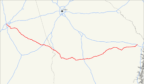
U.S. Route 280 is a spur of U.S. Highway 80. It currently runs for 392 miles (631 km) from Blichton, Georgia at U.S. Highway 80 to Birmingham, Alabama at I-20/I-59. For much of its route, U.S. 280 travels through rural areas and smaller cities in southern Georgia and east central Alabama. Once the highway approaches Birmingham, it is a major suburban route. Numerous shopping centers are located on U.S. 280 throughout northern Shelby County and southern Jefferson County.
U.S. Route 280 is the main connector between Birmingham, AL and Auburn, AL.
Through Talladega County, Alabama, U.S. 280 is known as the Jim Nabors Highway, in honor of the Sylacauga, Alabama, native known for portraying the television character Gomer Pyle. The historical designation of US-280 and Alabama SR-38 is the Florida Short Route.
For many years, US-280 and SR-38 was considered one of the more dangerous routes in Alabama, due to the number of large stretches of narrow two-lane roadway leading southeastwardly from Birmingham. Work was completed in 2006 making U.S. 280 a four-lane highway throughout the entire state of Alabama. This project began in the 1970s. As a result, U.S. 280 now bypasses numerous small towns in east Alabama, including Goodwater, Jackson's Gap, Camp Hill and Waverly.
In Georgia, US 280 from Columbus to I-16 is also a Governor's Road Improvement Program (GRIP) corridor known as "Power Alley".[1]
Route description

Alabama
US 280 begins at an interchange with Interstate 20, Interstate 59, and U.S. Route 31 in downtown Birmingham. US 280 continues south, cosigned with US 31 along the Elton B. Stephens Expressway (locally known as the Red Mountain Expressway). The routes interchange with U.S. Route 11 and U.S. Route 78 prior to exiting the city. At Homewood, the expressway comes to an end as US 280 separates from US 31. In Cahaba Heights, US 280 interchanges with Interstate 459.
US 280 is paired with unsigned State Route 38 throughout the state, except along the Red Mountain Expressway, where it and US-31 are both concurrent with unsigned State Route 3. The U.S. Highway has a length of 141.356 miles (227.490 km) in Alabama.[2]
Georgia
US 280 begins in Georgia at the state's border with Alabama in Columbus. There it is paired with State Route 520 and U.S. Route 27. It maintains this designation as it passes through Fort Benning. US 280 continues east, where it passes through Plains (the boyhood home of Jimmy Carter) and becomes cosigned State Route 30 in Americus. It maintains this designation until the route's terminus in Blichton.
History
Prior to the completion of the Elton B. Stephens Expressway in Birmingham, US 31, US 78, and US 280 traveled concurrently until they intersected US 11 at the intersection of 1st Avenue North and 24th Street.
Major intersections
| State | County | Location | mi[2] | km | Destinations | Notes | ||
|---|---|---|---|---|---|---|---|---|
| Alabama | Jefferson | Birmingham | 0.000 | 0.000 | Western terminus; western end of US 31/SR 3 concurrency; I-20/I-59 exit 126A | |||
| 0.729 | 1.173 | 2nd Avenue North | Westbound exit and eastbound entrance | |||||
| 0.835 | 1.344 | Westbound exit only | ||||||
| 1.245 | 2.004 | |||||||
| 1.598 | 2.572 | University Boulevard | ||||||
| Highland Avenue / Arlington Avenue | Westbound exit and eastbound entrance | |||||||
| 21st Avenue South | Eastbound exit and westbound entrance | |||||||
| Homewood | 3.331 | 5.361 | Eastern end of US 31/SR 3 concurrency; western end of SR 38 concurrency; western terminus of SR 38 | |||||
| Birmingham–Homewood line | Hollywood Boulevard – Mountain Brook, Birmingham Zoo–Gardens | Eastern end of freeway | ||||||
| Mountain Brook | 4.737 | 7.623 | Interchange | |||||
| Mountain Brook | Pump House Road – Cahaba Heights | Interchange | ||||||
| Birmingham | 7.899 | 12.712 | I-459 exit 19 | |||||
| Colonnade Drive | Interchange | |||||||
| Shelby | Hoover | 11.819 | 19.021 | |||||
| Harpersville | 29.431 | 47.365 | Western end of US 231/SR 53 concurrency | |||||
| Harpersville | 34.437 | 55.421 | Western end of SR 76 concurrency | |||||
| Talladega | Childersburg | 35.523 | 57.169 | Southern terminus of SR 235 | ||||
| 36.109 | 58.112 | Eastern end of SR 76 concurrency; eastern terminus of CR 008 | ||||||
| Sylacauga | 47.310 | 76.138 | Eastern end of US 231/SR 53 concurrency; interchange | |||||
| Coosa | Socapatoy | 63.362 | 101.971 | Interchange | ||||
| Kellyton | 65.221 | 104.963 | Northern terminus of SR 115 | |||||
| Tallapoosa | Alexander City | 70.096 | 112.809 | Western end of SR 22 concurrency | ||||
| 71.788 | 115.532 | Eastern end of SR 22 concurrency | ||||||
| Dadeville | 83.501 | 134.382 | Western end of SR 49 concurrency | |||||
| 84.821 | 136.506 | Eastern end of SR 49 concurrency | ||||||
| Camp Hill | Western end of SR 50 concurrency; eastern terminus of CR 34 | |||||||
| 91.488 | 147.236 | Eastern end of SR 50 concurrency | ||||||
| Chambers |
No major junctions | |||||||
| Lee | Auburn | 104.511 | 168.194 | Western end of SR 147 concurrency | ||||
| The Bottle | 104.911 | 168.838 | Eastern end of SR 147 concurrency | |||||
| Opelika | 110.241 | 177.416 | Pepperell Parkway | Former US 29 | ||||
| 111.851 | 180.007 | Western end of I-85/US 29/SR 15 concurrency; US 280 west follows exit 58. | ||||||
| 113.871 | 183.258 | I-85 exit 60 | ||||||
| 115.294 | 185.548 | Eastern end of I-85/US 29/SR 15 concurrency; western end of US 431/SR 1 concurrency; US 280 east follows exit 62. | ||||||
| Russell | Phenix City | 137.659 | 221.541 | Western end of US 80/SR 8 concurrency | ||||
| 138.598 | 223.052 | Eastern end of US 80/SR 8 concurrency | ||||||
| 140.466 | 226.058 | Eastern end of US 431/SR 1 concurrency; interchange | ||||||
| Colin L. Powell Parkway / Seale Road | Interchange | |||||||
| Chattahoochee River | 141.356 0.0 | 227.490 0.0 | Oglethorpe Bridge; Alabama–Georgia state line | |||||
| Georgia | Muscogee | Columbus | Western end of US 27/SR 1 concurrency | |||||
| See SR 520 (mile 0.0-35.1) | ||||||||
| Stewart | Richland | Eastern end of SR 520 concurrency; western end of SR 27 concurrency | ||||||
| Webster | Preston | Western end of SR 41 concurrency | ||||||
| Eastern end of SR 41 concurrency | ||||||||
| Sumter | Plains | Northern terminus of SR 45 | ||||||
| | Western end of SR 49 concurrency | |||||||
| | Western end of US 19/SR 3 concurrency | |||||||
| Americus | Eastern end of US 19/SR 3 concurrency; western end of SR 30 concurrency | |||||||
| Northern terminus of SR 377 | ||||||||
| Eastern end of SR 49 concurrency | ||||||||
| Eastern end of SR 27 concurrency | ||||||||
| Leslie | Western end of SR 195 concurrency; northern terminus of SR 118 | |||||||
| De Soto | Eastern end of SR 195 concurrency | |||||||
| Crisp | | Northern terminus of SR 300 Conn. | ||||||
| Cordele | Western end of SR 90 concurrency | |||||||
| I-75 exit 101 | ||||||||
| Eastern end of SR 90 concurrency | ||||||||
| Wilcox | Pitts | Northern terminus of SR 159 | ||||||
| Western end of SR 215 concurrency | ||||||||
| Rochelle | ||||||||
| Eastern end of SR 215 concurrency | ||||||||
| Abbeville | ||||||||
| Dodge | | Southern terminus of SR 87 | ||||||
| Rhine | Western end of SR 165 concurrency | |||||||
| Telfair | Milan | Eastern end of SR 165 concurrency | ||||||
| McRae-Helena | Western end of US 319/US 441/SR 31 concurrency | |||||||
| Southbound lanes of US 23/US 341/SR 27 on one-way pair | ||||||||
| Northbound lanes of US 23/US 341/SR 27 on one-way pair | ||||||||
| Wheeler | | Eastern end of US 319/US 441/SR 31 concurrency | ||||||
| | Northern terminus of SR 149 | |||||||
| Alamo | ||||||||
| Glenwood | ||||||||
| Montgomery | Mount Vernon | |||||||
| Ailey | Broad Street | Former SR 227 north | ||||||
| Higgston | Western end of SR 15/SR 29 concurrency; northern terminus of SR 135 | |||||||
| Toombs | Vidalia | |||||||
| Eastern end of SR 15/SR 29 concurrency | ||||||||
| Lyons | ||||||||
| | Eastern terminus of SR 86 | |||||||
| Tattnall | Reidsville | Eastern terminus of SR 56 | ||||||
| Eastern terminus of SR 147 | ||||||||
| Evans | Bellville | |||||||
| | Eastern terminus of SR 292 | |||||||
| Claxton | Western end of SR 129 concurrency | |||||||
| Eastern end of SR 129 concurrency | ||||||||
| Bryan | Pembroke | Western end of SR 67/SR 119 concurrency | ||||||
| Eastern end of SR 67/SR 119 concurrency | ||||||||
| Lanier | Western terminus of SR 204 | |||||||
| | I-16 exit 143 | |||||||
| Blitchton | Eastern terminus; eastern end of SR 30 concurrency; former US 280 east | |||||||
1.000 mi = 1.609 km; 1.000 km = 0.621 mi
| ||||||||
References
- ↑ "Governor's Road Improvement Program (GRIP)". Georgia Department of Transportation. 2012. Archived from the original on February 20, 2014. Retrieved February 24, 2014.
- 1 2 Alabama Department of Transportation. "Milepost Maps". Archived from the original on 2011-07-27. Retrieved 2011-11-23.
- Jefferson County (PDF)
- Shelby County (PDF)
- Talladega County (PDF)
- Coosa County (PDF)
- Tallapoosa County (PDF)
- Chambers County (PDF)
- Lee County (PDF)
- Russell County (PDF)
External links
Route map: