Georgia State Route 204
| ||||
|---|---|---|---|---|
 | ||||
| Route information | ||||
| Maintained by GDOT | ||||
| Length | 36.1 mi[1] (58.1 km) | |||
| Major junctions | ||||
| West end |
| |||
|
| ||||
| East end |
| |||
| Location | ||||
| Counties | Bryan, Chatham | |||
| Highway system | ||||
| ||||

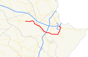
State Route 204 (SR 204) is a 36.1-mile-long (58.1 km) state highway in the east-central part of the U.S. state of Georgia. It runs from a point east of Pembroke and ends in Downtown Savannah. Its routing is located within portions of Bryan and Chatham counties.
Route description
SR 204 begins at an intersection with US 280/SR 30 in Lanier, Georgia. It heads east through Ellabell, Georgia. It curves to the southeast and parallels the northeastern part of Fort Stewart. It has an interchange with Interstate 95 (I-95), followed by an intersection with US 17/SR 25 (Ocean Highway), an interchange with King George Boulevard, and an interchange with the Veterans Parkway (also known as the Southwest Bypass) southwest of Savannah, in Georgetown. It curves to the northeast and meets SR 204 Spur (Montgomery Cross Road). It then continues northeast to an intersection with SR 21 (DeRenne Avenue), which leads to I-516. Then, it meets US 80/SR 26 (Victory Drive). A short distance later, it turns left onto 37th Street, and follows that until it meets its eastern terminus, an interchange with I-16/US 17.[1]
The highway is two lanes as it travels east through rural Bryan County and the Ellabell community. Once it crosses the Ogeechee River and enters Chatham County, the highway becomes known as Fort Argyle Road. Development is more noticeable as one travels east, and there is a large collection of businesses catering to travelers at the interchange with I-95. It is at this interchange that the highway changes from two lanes to four divided lanes. Traffic is often quite heavy as SR 204 is the major route from I-95 into the busy south side of Savannah. Though SR 204 is known as Abercorn Expressway as it enters Savannah, it is not a freeway until after it passes through a signal at Grove Point Road. While there is a grade separated interchange at US 17/SR 25, there is a at-grade signalized intersection at Grove Point Road, which can cause traffic delays, as it continues closer to Savannah, it becomes a true freeway with an intersection at King George Boulevard (which used to be a signal), where the highway becomes six lanes divided, and another intersection with Veterans Parkway. The speed limit is 45 miles per hour (72 km/h).The route enters Savannah city limits as it crosses the Forest River. At the signaled intersection with Rio Road, adjacent to the Savannah Mall, the highway losses its controlled access. As the route continues through the south side of Savannah it has an interchange where the Harry S. Truman Parkway begins. It remains six lanes until an intersection with DeRenne Avenue, where it becomes four lanes as it enters historic residential areas. SR 204 continues to follow Abercorn Street north for several blocks to its intersection with 37th Street. Here, it turns left and follows 37th Street, a four lane divided surface arterial, west for a number of blocks. Just west of its intersection with Bulloch Street, SR 204 bears right to follow the short 37th Street Connector, which leads to I-16/US 17, and thus the end of State Route 204.[1]
National Highway System
The west–east portion of SR 204 east of I-95 is the only part of the road that is included within the National Highway System, a system of roadways important to the nation's economy, defense, and mobility.[2]
Miscellaneous notes
In Savannah, SR 204 is a very major and heavily traveled surface arterial road and is known as Abercorn Expressway, Abercorn Street, and 37th Street.
History
The portion of the route running along Abercorn Street was previously numbered as State Route 359.
Major intersections
| County | Location | mi[1] | km | Destinations | Notes |
|---|---|---|---|---|---|
| Bryan | | 0.0 | 0.0 | Western terminus | |
| Chatham | | 19.4 | 31.2 | I-95 exit 94 | |
| | 21.2 | 34.1 | |||
| Savannah | 30.0 | 48.3 | Western terminus of SR 204 Spur | ||
| 32.4 | 52.1 | Southern terminus of SR 21 | |||
| 34.2 | 55.0 | ||||
| 36.1 | 58.1 | Eastern terminus; I-16 exit 165; no access to I-16 east/US 17 north from SR 204 east | |||
| 1.000 mi = 1.609 km; 1.000 km = 0.621 mi | |||||
Related route
| |
|---|---|
| Location | Savannah |
| Length | 7.2 mi[3] (11.6 km) |
State Route 204 Spur (SR 204 Spur) is a spur route of SR 204 that connects the mainline to Skidaway Island. Segments of SR 204 Spur are named East Montgomery Cross Road, Waters Avenue, Whitfield Avenue, Diamond Causeway, and Tidewater Way.[3]
SR 204 Spur is not part of the National Highway System, a system of roadways important to the nation's economy, defense, and mobility.[2]
The entire route is in Chatham County.
| Location | mi[3] | km | Destinations | Notes | |
|---|---|---|---|---|---|
| Savannah | 0.0 | 0.0 | Western terminus | ||
| Skidaway Island | 7.2 | 11.6 | Tidewater Way / Green Island Road / McWhorter Drive | Eastern terminus | |
| 1.000 mi = 1.609 km; 1.000 km = 0.621 mi | |||||
See also
.svg.png)

References
- 1 2 3 4 Google (June 18, 2013). "Route of SR 204" (Map). Google Maps. Google. Retrieved June 18, 2013.
- 1 2 "National Highway System: Georgia" (PDF). United States Department of Transportation. May 8, 2009. Retrieved June 19, 2013.
- 1 2 3 Google (June 19, 2013). "Overview map of SR 204 Spur" (Map). Google Maps. Google. Retrieved June 19, 2013.