Georgia State Route 67
| ||||
|---|---|---|---|---|
 | ||||
| Route information | ||||
| Maintained by GDOT | ||||
| Length | 59.2 mi[1] (95.3 km) | |||
| Major junctions | ||||
| South end | Northern edge of Fort Stewart, southeast of Pembroke | |||
|
| ||||
| North end |
| |||
| Location | ||||
| Counties | Bryan, Bulloch, Jenkins | |||
| Highway system | ||||
| ||||

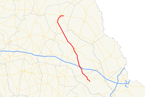
State Route 67 (SR 67) is a 59.2-mile-long (95.3 km) state highway that runs south-to-north through portions of Bryan, Bulloch, and Jenkins counties in the east-central part of the U.S. state of Georgia. The route connects Fort Stewart and Pembroke with Millen, via Statesboro.
Route description
SR 67 begins on the northeastern edge of Fort Stewart, approximately 2.2 miles (3.5 km) southeast of Pembroke, within Bryan County. The highway travels northwest, through rural areas of the county, into Pembroke. It curve to the north-northeast to an intersection with US 280/SR 30 (East Bacon Street). At this intersection both SR 67 and SR 119 join that concurrency. One block later, SR 67 splits off to the north, while SR 119 splits off to the south. SR 67 continues to the northwest, leaving town and crosses into Bulloch County. The highway continues to the northwest and has an interchange with Interstate 16 (I-16), just before entering Denmark. In Denmark, it intersects SR 46. It passes through rural areas of the county, until it enters Statesboro. In town, it intersects US 301 Bypass/SR 67 Bypass/SR 73 Bypass (Veterans Memorial Parkway), at the southeastern edge of Georgia Southern University. It runs along the northeastern edge of the university, before meeting US 25/US 301/SR 73 (South Main Street). The four highway head concurrent to the north. At East Main Street, they intersect the western terminus of SR 24. In the main part of town, they intersect US 80/SR 26. There, US 301/SR 73 split off to the north and northeast, while US 25/US 80/SR 26/SR 67 head northwest. Just after leaving town, they meet US 25 Bypass/SR 67 Bypass. In Hopeulikit, US 80/SR 26 split off to the southwest. Here, US 25/SR 67 continue to the northwest and enter Jenkins County. A little distance before entering Millen, first SR 121 and then SR 23 join the concurrency. Just after entering Millen, SR 17 Bypass (South Gray Street) joins the concurrency. The five routes head concurrent into the main part of town. At SR 17 (Winthrope Avenue), SR 17 Bypass ends, US 25/SR 121 continue to the north, and SR 17/SR 23/SR 67 head concurrent to the east. At Masonic Street, SR 17 splits off to the south, and SR 23 splits off to the north. SR 67 continues to the east, passing the Jenkins County Hospital. Then, it continue to the east until it meets its northern terminus, an intersection with SR 21 (Millen Bypass), just east of town.[1]
All of SR 67 that is concurrent with US 25 is included as part of the National Highway System, a system of roadways important to the nation's economy, defense, and mobility.[2]
Major intersections
| County | Location | mi[1] | km | Destinations | Notes |
|---|---|---|---|---|---|
| Bryan | | 0.0 | 0.0 | Northeastern edge of Fort Stewart | Southern terminus; roadway blocked, no access to post |
| Pembroke | 3.3 | 5.3 | Southern end of US 280/SR 30/SR 119 concurrency | ||
| 3.3 | 5.3 | Northern end of US 280/SR 30/SR 119 concurrency | |||
| Bulloch | | 13.4 | 21.6 | I-16 exit 127 | |
| | 14.7 | 23.7 | Southern end of SR 46 concurrency | ||
| Denmark | 14.8 | 23.8 | Northern end of SR 46 concurrency | ||
| Statesboro | 24.6 | 39.6 | Southern terminus of SR 67 Byp. | ||
| 27.2 | 43.8 | Southern end of US 25 and US 301/SR 73 concurrencies | |||
| 28.3 | 45.5 | Northern end of US 301/SR 73 concurrency; southern end of US 80/SR 26 concurrency | |||
| | 30.4 | 48.9 | Northern terminus of US 25 Byp./SR 67 Byp. | ||
| Hopeulikit | 34.8 | 56.0 | Northern end of US 80/SR 26 concurrency | ||
| Jenkins | | 51.5 | 82.9 | Southern end of SR 121 concurrency | |
| | 53.2 | 85.6 | Southern end of SR 23 concurrency | ||
| | 55.4 | 89.2 | Ogeechee River | ||
| Millen | 56.1 | 90.3 | Southern end of SR 17 Byp. concurrency | ||
| 56.7 | 91.2 | Northern end of US 25/SR 121 and SR 17 Byp. concurrencies; southern end of SR 17 concurrency; northern terminus of SR 17 Byp. | |||
| 57.4 | 92.4 | Northern end of SR 17 concurrency | |||
| 57.4 | 92.4 | Northern end of SR 23 concurrency | |||
| | 59.2 | 95.3 | Northern terminus | ||
1.000 mi = 1.609 km; 1.000 km = 0.621 mi
| |||||
Statesboro bypass
| |
|---|---|
| Location | Statesboro |
| Length | 7.3 mi[3] (11.7 km) |
State Route 67 Bypass (SR 67 Byp.) is a 7.3-mile-long (11.7 km) bypass route of SR 67 that exists entirely within the central part of Bulloch County. The southern part is located within the Statesboro city limits.
It begins at an intersection with the SR 67 mainline (Fair Road) in the southeastern part of Statesboro. At this intersection, SR 67 Byp. begins a concurrency with US 301 Byp./SR 73 Byp. (Veterans Memorial Parkway) to the west. The three routes skirt along the southern edge of Georgia Southern University until they intersect US 25/US 301/SR 73 (South Main Street). At this intersection, US 301 Byp./SR 73 Byp. end, and US 25 Bypass begins. The two highways leave the city limits and skirt around the west side of the city until they meet their northern terminus, an intersection with US 25/US 80/SR 26/SR 67 just northwest of the town.[3]
All of SR 67 Byp. is included as part of the National Highway System, a system of roadways important to the nation's economy, defense, and mobility.[2]
The entire route is in Bulloch County.
| Location | mi[1] | km | Destinations | Notes | |
|---|---|---|---|---|---|
| Statesboro | 0.0 | 0.0 | Southern terminus; southern end of US 301 Byp./SR 73 Byp. concurrency | ||
| 2.3 | 3.7 | Southern terminus of US 25 Byp./US 301 Byp./SR 73 Byp.; northern end of US 301 Byp./SR 73 Byp. concurrency; southern end of US 25 Byp. concurrency | |||
| | 7.3 | 11.7 | Northern terminus of US 25 Byp./SR 67 Byp.; northern end of US 25 Byp. concurrency | ||
1.000 mi = 1.609 km; 1.000 km = 0.621 mi
| |||||
See also
.svg.png)

References
- 1 2 3 4 Google (July 28, 2013). "Route of SR 67" (Map). Google Maps. Google. Retrieved July 28, 2013.
- 1 2 "National Highway System: Georgia" (PDF). United States Department of Transportation. October 1, 2012. Retrieved July 30, 2013.
- 1 2 Google (July 30, 2013). "Overview map of SR 67 Byp." (Map). Google Maps. Google. Retrieved July 30, 2013.