Horseshoe Bend National Military Park
| Horseshoe Bend National Military Park | |
|---|---|
 | |
  | |
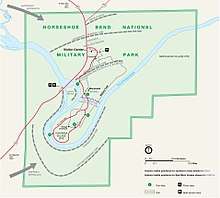
| Location | Tallapoosa County, Alabama, USA |
| Nearest city | Alexander City, Alabama |
| Coordinates | 32°58′15″N 85°44′18″W / 32.97083°N 85.73833°WCoordinates: 32°58′15″N 85°44′18″W / 32.97083°N 85.73833°W |
| Area | 2,040 acres (8.3 km2) |
| Established | July 25, 1956 |
| Visitors | 58,564 (in 2005) |
| Governing body | National Park Service |
| Website | |
|
Horseshoe Bend National Military Park | |
| Built | 1813 |
| NRHP reference # | 66000060[1] |
| Added to NRHP | October 15, 1966 |
Horseshoe Bend National Military Park is a U.S. national military park managed by the National Park Service that is the site of the last battle of the Creek War on March 27, 1814. General Andrew Jackson's Tennessee militia, aided by the 39th U.S. Infantry Regiment and Cherokee and Lower Creek allies, finally crushed Upper Creek Red Stick resistance during the Battle of Horseshoe Bend at this site on the Tallapoosa River. Jackson's decisive victory at Horseshoe Bend broke the power of the Creek Nation.
Over 800 Upper Creeks died defending their homeland. This was the largest loss of life for Native Americans in a single battle in the history of United States.[2]
On August 9, 1814, the Creeks signed the Treaty of Fort Jackson, which ceded 23 million acres (93,000 km2) of land in Alabama and Georgia to the United States government.
References
- ↑ National Park Service (2010-07-09). "National Register Information System". National Register of Historic Places. National Park Service.
- ↑ "Horseshoe Bend National Military Park". National Park Service. Retrieved 2008-03-01.
External links
- Official site: Horseshoe Bend National Military Park
| Topics | |
|---|---|
| Lists by states |
|
| Lists by insular areas | |
| Lists by associated states | |
| Other areas | |
| |