Tual, Indonesia
| Tual | ||
|---|---|---|
| City | ||
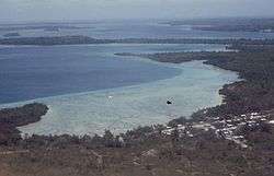 Air photo of the coast at Tual | ||
| ||
| Motto(s): Larwur Ngabal | ||
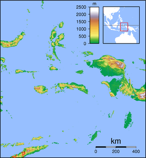
 Location within Maluku | ||
| Coordinates: 5°38′12.5″S 132°45′3″E / 5.636806°S 132.75083°ECoordinates: 5°38′12.5″S 132°45′3″E / 5.636806°S 132.75083°E | ||
| Country |
| |
| Province |
| |
| Establishment | 2007[1] | |
| Government | ||
| • Mayor | Adam Rahayaan | |
| • Vice Mayor | Abdul Hamid Rahayaan | |
| Area | ||
| • Total | 254.4 km2 (98.2 sq mi) | |
| Population (2015)[2] | ||
| • Total | 67,783 | |
| • Density | 266.4/km2 (690/sq mi) | |
| Time zone | UTC+9 (Indonesia Eastern Time) | |
| Area code | (+62) 916 | |
| Vehicle registration | DE | |
| Website | tualkota.go.id | |


Tual is a city in Maluku Province of Indonesia. The city, called Kota Tual in Indonesian, is geographically located within the Kei Islands, on Dullah Island, but since 2007 has been administratively separate from the rest of the Kei Islands, which form the Southeast Maluku Regency (the city is on the same administrative level as the Regency). The city covers an area of 254.4 sq.km, and includes a number of small islands situated to the west of the principal Kei Islands (Kei Besar and Kei Kecil).
History
The city was located in one of the key maritime routes of the spice trade which extended from the Moluccas southwards towards the Lesser Sunda Islands and Java, which have had significant effects on the culture and people in the region.
Inhabitants of the Kai Islands are believed to have migrated from the larger island of Seram. Local cultures were exposed to that of the Balinese in the 14th century, during the expansion of the Majapahit Empire. After its collapse, however, the local elders known as Halaai formed a local set of government and laws (known as the Larwul Ngaal) which stood until European arrival to the archipelago. After the Dutch East India Company conquered the area sometime in the 17th century, the elders were replaced with "kings".
During the Second World War, Japanese soldiers landed on the island and several Roman Catholic missionaries were executed. The area remained largely untouched by the insurgency in South Maluku during the 1960s. In 2007, the city (which includes a number of far-flung islands to the west of it) was administratively separated from the Southeast Maluku Regency[1].
Administration
The city is divided into four districts (kecamatan), tabulated below with their 2010 Census population.
| Name | Area in sq.km | Population Census 2010 | Notes |
|---|---|---|---|
| Pulau Dullah Selatan | 42.8 | 33,175 | Southern Dullah Island (including Tual town) |
| Pulau Dullah Utara | 72.3 | 14,564 | Northern Dullah Island, and Dullah Laut Island |
| Tayando Tam | 69.2 | 5,448 | Tayandu Islands (Tayandu, Heniar, Nusreen) and Taam |
| Pulau-Pulau Kur | 54.7 | 4,895 | Kuur Islands, including Mangur, Fadol and others) |
Climate
Tual has a typical Tropical rainforest climate, hot and humid all year round.
| Climate data for Tual, Maluku, Indonesia | |||||||||||||
|---|---|---|---|---|---|---|---|---|---|---|---|---|---|
| Month | Jan | Feb | Mar | Apr | May | Jun | Jul | Aug | Sep | Oct | Nov | Dec | Year |
| Record high °C | 33 | 38 | 37 | 37 | 32 | 31 | 39 | 35 | 36 | 35 | 37 | 42 | 42 |
| Average high °C | 28 | 29 | 29 | 29 | 29 | 28 | 27 | 27 | 28 | 30 | 30 | 29 | 29 |
| Daily mean °C | 27 | 27 | 27 | 28 | 28 | 27 | 26 | 26 | 27 | 28 | 28 | 27 | 27 |
| Average low °C | 26 | 26 | 26 | 26 | 26 | 25 | 25 | 25 | 26 | 26 | 26 | 26 | 26 |
| Record low °C | 19 | 21 | 18 | 20 | 22 | 22 | 20 | 21 | 20 | 20 | 21 | 22 | 18 |
| Average precipitation mm | 380 | 340 | 340 | 260 | 230 | 150 | 110 | 70 | 60 | 60 | 150 | 340 | 2,600 |
| Record high °F | 91 | 100 | 99 | 99 | 90 | 88 | 102 | 95 | 97 | 95 | 99 | 108 | 108 |
| Average high °F | 82 | 84 | 84 | 84 | 84 | 82 | 81 | 81 | 82 | 86 | 86 | 84 | 84 |
| Daily mean °F | 81 | 81 | 81 | 82 | 82 | 81 | 79 | 79 | 81 | 82 | 82 | 81 | 81 |
| Average low °F | 79 | 79 | 79 | 79 | 79 | 77 | 77 | 77 | 79 | 79 | 79 | 79 | 79 |
| Record low °F | 66 | 70 | 64 | 68 | 72 | 72 | 68 | 70 | 68 | 68 | 70 | 72 | 64 |
| Average precipitation inches | 14.96 | 13.39 | 13.39 | 10.24 | 9.06 | 5.91 | 4.33 | 2.76 | 2.36 | 2.36 | 5.91 | 13.39 | 102.36 |
| Average relative humidity (%) (daily average) | 81 | 80 | 79 | 78 | 77 | 79 | 76 | 74 | 72 | 71 | 73 | 80 | 77 |
| Mean daily sunshine hours | 12.8 | 12.6 | 12.5 | 12.3 | 12.2 | 12.2 | 12.2 | 12.3 | 12.4 | 12.6 | 12.7 | 12.8 | 12.5 |
| Source: [3] | |||||||||||||
Friendly city
| city | area | country | sign time |
|---|---|---|---|
| Malé | March 2017 | ||
| Sorong | March 2017 | ||
| Manggar | January 2017 | ||
| Suva | February 2017 |
References
- 1 2 Loupatty, Stenly R. "Sejarah Kota Tual" (PDF). Indonesian Ministry of Education.
- ↑ "Jumlah Penduduk Kota Tual menurut Kecamatan dan Jenis Kelamin Tahun 2015". BPS Kota Tual. Indonesian Bureau of Statistics. Retrieved 21 July 2017.
- ↑ "weatherbase - TUAL, INDONESIA". weatherbase.
External links
| Wikimedia Commons has media related to Tual. |