Southeast Maluku Regency
| Southeast Maluku Regency Kabupaten Maluku Tenggara | ||
|---|---|---|
| Regency | ||
| ||
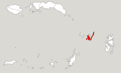 Location within Maluku | ||
| Coordinates: 5°39′17″S 132°44′22″E / 5.6548°S 132.7394°ECoordinates: 5°39′17″S 132°44′22″E / 5.6548°S 132.7394°E | ||
| Country | Indonesia | |
| Province | Maluku | |
| Capital | Langgur | |
| Government | ||
| • Regent | Anderias Rentanubun | |
| • Vice Regent | Yunus Serang | |
| Area | ||
| • Total | 1,031.81 km2 (398.38 sq mi) | |
| Population (2014) | ||
| • Total | 107,428 | |
| • Density | 100/km2 (270/sq mi) | |
| Time zone | UTC+9 (IEST) | |
| Area code | (+62) 916 | |
| Website |
malukutenggarakab | |


Southeast Maluku Regency (Indonesian: Kabupaten Maluku Tenggara) is a regency of Maluku, Indonesia. It is coincident with the Kei Islands, except that the city of Tual, although within the Kei Islands geographically and the seat of the Regency's administration, is technically independent of the Regency. The land area of the Regency is 1,031.81 km², and it had a population of 96,442 at the 2010 Census;[1] the latest official estimate (as at January 2014) was 107,428. The capital is located in Langgur.[2]
Administration
The regency is divided into six districts (kecamatan), tabulated below with their 2010 Census population.[3]
| Name | English name | Area in sq.km | Population Census 2010 |
|---|---|---|---|
| Kei Besar | Great Kei | 278.0 | 22,489 |
| Kei Besar Selatan | South Great Kei | 117.9 | 7,589 |
| Kei Besar Utara Timur | Northeast Great Kei | 157.6 | 9,626 |
| Kei Kecil | Little Kei | 255.3 | 40,336 |
| Kei Kecil Barat | West Little Kei | 89.2 | 5,728 |
| Kei Kecil Timur | East Little Kei | 119.4 | 10,674 |
Transport
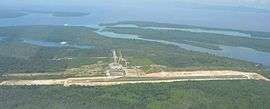
Aerial view of Dumatubun Airport at Langgur
A small airport named Dumatubun Airport located in Langgur urban midwest.
References
- ↑ Biro Pusat Statistik, Jakarta, 2011.
- ↑ Peraturan Pemerintah Republik Indonesia Nomor 35 Tahun 2011 Tentang Pemindahan Ibu Kota Kabupaten Maluku Tenggara Dari Wilayah Kota Tual Ke Wilayah Kecamatan Kei Kecil Kabupaten Maluku Tenggara Provinsi Maluku Archived 2012-04-02 at the Wayback Machine.
- ↑ Biro Pusat Statistik, Jakarta, 2011.
External links
| Wikimedia Commons has media related to Southeast Maluku Regency. |
This article is issued from
Wikipedia.
The text is licensed under Creative Commons - Attribution - Sharealike.
Additional terms may apply for the media files.