Tsushima Airport
| Tsushima Airport 対馬空港 | |||||||||||
|---|---|---|---|---|---|---|---|---|---|---|---|
 | |||||||||||
| Summary | |||||||||||
| Airport type | Public | ||||||||||
| Operator | Nagasaki Prefecture (airfield); Tsushima Airport Terminal Building Co., Ltd. (terminal) | ||||||||||
| Serves | Tsushima, Japan | ||||||||||
| Elevation AMSL | 207 ft / 63 m | ||||||||||
| Coordinates | 34°17′06″N 129°19′50″E / 34.28500°N 129.33056°ECoordinates: 34°17′06″N 129°19′50″E / 34.28500°N 129.33056°E | ||||||||||
| Map | |||||||||||
 RJDT Location in Japan | |||||||||||
| Runways | |||||||||||
| |||||||||||
| Statistics (2015) | |||||||||||
| |||||||||||
|
Source: Japanese Ministry of Land, Infrastructure, Transport and Tourism[1] | |||||||||||
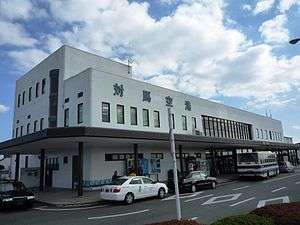
Tsushima Airport (対馬空港) (IATA: TSJ, ICAO: RJDT) is an airport located 10 km (6.2 mi) northeast[2] Tsushima, a city in the Nagasaki Prefecture of Japan.

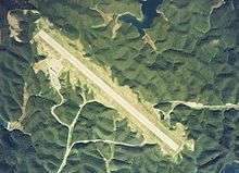
Aerial photo of Tsushima airport
Airlines and destinations
| Airlines | Destinations |
|---|---|
| All Nippon Airways operated by ANA Wings | Fukuoka |
| Oriental Air Bridge | Nagasaki |
History
The airport opened in 1975 on a site created by leveling a small mountain.[3]
In 2003, a small propeller training aircraft used by Sojo University crashed on approach to Tsushima, killing three occupants.[4]
Scheduled flights to and from the airport use Boeing 737 and Bombardier Dash 8 aircraft.[5] The airport has also been served by Korea Express Air turboprop service from Seoul Gimpo and Daegu.[6]
References
- ↑ "Tsushima Airport" (PDF). Japanese Ministry of Land, Infrastructure, Transport and Tourism. Archived from the original (PDF) on 21 October 2016. Retrieved 7 January 2017.
- ↑ AIS Japan Archived 2011-07-22 at the Wayback Machine.
- ↑ "大阪航空局_大阪航空局のご案内_管内空港の現況と出先機関_対馬空港". ocab.mlit.go.jp. Retrieved 2017-10-04.
- ↑ "航空トラブル:小型機胴体着陸 けが人なし 長崎空港、大学の訓練用 - 毎日新聞". 毎日新聞 (in Japanese). Retrieved 2017-10-04.
- ↑ "機材 | 対馬空港ターミナルビル株式会社". tsushima-airport.co.jp (in Japanese). Retrieved 2017-10-04.
- ↑ "Tsushima: Pinnacle for Cycling". koreatimes. 2009-08-20. Retrieved 2017-10-04.
External links
This article is issued from
Wikipedia.
The text is licensed under Creative Commons - Attribution - Sharealike.
Additional terms may apply for the media files.