Trams in Berlin
| Berlin tramway | ||||||||||||||||||||||||||||
|---|---|---|---|---|---|---|---|---|---|---|---|---|---|---|---|---|---|---|---|---|---|---|---|---|---|---|---|---|
 | ||||||||||||||||||||||||||||
| Operation | ||||||||||||||||||||||||||||
| Locale | Berlin, Germany | |||||||||||||||||||||||||||
| ||||||||||||||||||||||||||||
| ||||||||||||||||||||||||||||
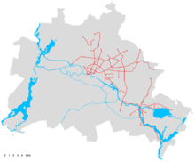
The Berlin tramway (German: Straßenbahn Berlin) is the main tram system in Berlin, Germany. It is one of the oldest tram networks in the world having its origins in 1865[6] and is operated by Berliner Verkehrsbetriebe (BVG), which was founded in 1929.[6] It is notable for being the third-largest tram system in the world, after Melbourne and St. Petersburg.[7] Berlin's streetcar system is made up of 22 lines[1] that operate across a standard gauge network, with almost 800 stops and measuring almost 190 kilometres (120 mi) in route length and 430 kilometres (270 mi) in line length.[4] Nine of the lines, called Metrotram, are operated continuously around the clock, and are identified with the letter "M" before their number;[2] the other thirteen lines are regular city tram lines and are identified by just a line number.[3]
Most of the recent network is within the confines of the former East Berlin—tram lines within West Berlin having been replaced by buses during the division of Berlin (the first extension into West Berlin opened in 1994 on today's M13). In the eastern vicinity of the city there are also three private tram lines that are not part of the main system, whereas to the south-west of Berlin is the Potsdam tram system with its own network of lines.
History
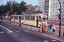
In 1865, a horse tramway was established in Berlin. In 1881, the world's first electric tram line opened. Numerous private and municipal operating companies constructed new routes, so by the end of the 19th century the network developed quite rapidly, and the horse trams were changed into electric ones. By 1930, the network had a route length of over 630 km (391 mi) with more than 90 lines. In 1929, all operating companies were unified into the BVG. After World War II, BVG was divided into an eastern and a western company but was once again reunited in 1992, after the fall of East Germany. In West Berlin, by 1967 the last tram lines had been shut down. With the exception of two lines constructed after German reunification, the Berlin tram continues to be limited to the eastern portion of Berlin.
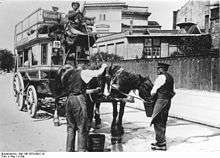
Horse buses
The public transport system of Berlin is the oldest one in Germany. In 1825, the first bus line from Brandenburger Tor to Charlottenburg was opened by Simon Kremser, already with a timetable.[8] The first bus service inside the city has operated since 1840 between Alexanderplatz and Potsdamer Bahnhof. It was run by Israel Moses Henoch, who had organized the cab service since 1815.[9][10] On 1 January 1847, the Concessionierte Berliner Omnibus Compagnie (Concessionary Berlin Bus Company) started its first horse-bus line. The growing market witnessed the launch of numerous additional companies, with 36 bus companies in Berlin by 1864.
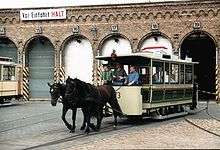
Horse trams
On 22 June 1865, the opening of Berlin's first horse tramway marked the beginning of the age of trams in Germany, spanning from Brandenburger Tor along today's Straße des 17. Juni (17 June Road) to Charlottenburg. Two months later, on 28 August, it was extended along Dorotheenstraße to Kupfergraben near today's Museumsinsel (Museum Island), a terminal stop which is still in service today. Like the horse-bus, many companies followed the new development and built horse-tram networks in all parts of the today's urban area. In 1873, a route from Rosenthaler Platz to the Gesundbrunnen was opened, to be operated by the new Große Berliner Pferde-Eisenbahn (Great Berlin Horse Railway) which would later become the dominant company in Berlin under the name of Große Berliner Straßenbahn (GBS; Great Berlin Tramway).
Electrification
On 16 May 1881, the region of Berlin again wrote transport history. In the village of Groß-Lichterfelde, which was incorporated into Berlin-Steglitz 39 years later, Werner von Siemens opened the world's first electric tramway. The electric tram in Groß-Lichterfelde was built to 1,000 mm (3 ft 3 3⁄8 in) metre gauge and ran from today's suburban station, Lichterfelde Ost, to the cadet school on Zehlendorfer Straße (today Finckensteinallee). Initially, the route was intended merely as a testing facility. Siemens named it an "elevated line taken down from its pillars and girders" because he wanted to build a network of electric elevated lines in Berlin. But the skeptical town council did not allow him to do this until 1902, when the first elevated line opened.
The first tests of electric traction on Berlin's standard gauge began on 1 May 1882, with overhead supply and in 1886 with chemical accumulators, were not very successful. Definitively, electric traction of standard-gauge trams in Berlin was established in 1895. The first tram line with an overhead track supply ran in an industrial area near Berlin-Gesundbrunnen station. The first line in more a representative area took place with accumulators for its first year, but got a catenary, too, four years later. In 1902, the electrification with overhead wiring had been completed, except for very few lines on the periphery.
The last horse-drawn tram line closed in 1910.
Underground trams
On 28 December 1899, it became possible to travel underground, even under the Spree, upon completion of the Spreetunnel between Stralau and Treptow. Owing to structural problems, it was closed on 25 February 1932. From 1916 to 1951, the tram had a second tunnel, the Lindentunnel, passing under the well-known boulevard Unter den Linden.
Great variety of companies until the formation of the BVG
The history of tramway companies of the Berlin Strassenbahn is very complicated. Besides the private companies, which often changed because of takeovers, mergers, and bankruptcies, the cities of Berlin, Spandau, Köpenick, Rixdorf; the villages Steglitz, Mariendorf, Britz, Niederschönhausen, Friedrichshagen, Heiligensee and Französisch Buchholz, and the Kreis Teltow (Teltow district) had municipal tramway companies.
The most important private operating company was the Große Berliner Pferde-Eisenbahn (Great Berlin Horse Railway), which called itself Große Berliner Straßenbahn (GBS) (Great Berlin Tramway) after starting the electrification. GBS acquired nearly all of the other companies through the years. In 1920, the GBS merged with the municipal companies BESTAG and SSB to become the Berliner Straßenbahn (Berlin Tramway), which was reorganized in 1929 into the newly formed municipal Berliner Verkehrs-AG (BVG) (Berlin Transport Company). Besides the tramway, the BVG also took over the elevated and underground rail lines and the bus routes which were previously operated primarily by the Allgemeine Berliner Omnibus-Actien-Gesellschaft (ABOAG) (General Berlin Bus Corporation).
The following table includes all companies that operated tramways in today's Berlin before the formation of the BVG. The background color of each line marks the drive method which the respective company used to serve their lines at the time of the formation (blue = horse tram, yellow = steam tram, white = electric tram, red = benzole tram).
| First line opened | Operating company | Gauge (mm) | Takeover date | Taken over by | Special remarks |
|---|---|---|---|---|---|
| 1865-06-22 | Berliner Pferde-Eisenbahn-Gesellschaft (BPfEG) | 1,435 | 1894-09-26 | BChS | first horse tram in Germany |
| 1871-11-01 | Westend-Terrain-Gesellschaft H. Quistorp & Co. | 1,435 | 1878 | BPfEG | |
| 1873-07-08 | Große Berliner Pferde-Eisenbahn (GBPfE) | 1,435 | 1898-01-25 | GBS | |
| 1877-01-01 | Neue Berliner Pferdebahn-Gesellschaft (NBPfG) | 1,435 | 1900-01-01 | GBS | |
| 1879-04-01 | Große Internationale Pferde-Eisenbahn-Gesellschaft (GIPfEG) | 1,435 | 1886 | GBPfE | founded already in March 1872 |
| 1881-05-16 | Elektrische Straßenbahn der Gemeinde Groß-Lichterfelde | 1,000 | 1895-03-04 | ESGLSS | Germany's first electric tramway |
| 1882-10-18 | Cöpenicker Pferde-Eisenbahn (CPE) | 1,435 | 1903 | SSC | |
| 1885-06-13 | Pferde-Eisenbahn der Gemeinde Rixdorf | 1,435 | 1887-01-01 | GBPfE | |
| 1886-05-05 | Davy, Donath & Co. | 1,435 | 1888-12-22 | BDK | |
| 1887-08-06 | Pferde-Eisenbahn der Gemeinde Mariendorf | 1,435 | 1888-01-01 | GBPfE | |
| 1888-05-18 | Wilmersdorf-Schmargendorfer Dampfstraßenbahn Reymer & Masch (WSD) | 1,435 | 1888-12-22 | BDK | |
| 1888-07-01 | Dampfstraßenbahn Groß-Lichterfelde - Seehof - Teltow | 1,435 | 1891-05-31 | DLSTS | |
| 1888-12-22 | Berliner Dampfstraßenbahn-Konsortium (BDK) | 1,435 | 1898-10-01 | WBV | also operated some horse trams |
| 1891-05-17 | Straßenbahn Friedrichshagen | 1,000 | 1906-12-16 | SSC | in 1894 taken over by the village, electrificated and regauged to standard gauge as of the takeover by SSC |
| 1891-05-31 | Dampfstraßenbahn Groß-Lichterfelde - Seehof - Teltow - Stahnsdorf | 1,435 | 1906-04-01 | TKb | |
| 1891-06-04 | Pferdebahn Tegeler Chaussee - Tegel | 1,435 | 1891-06-04 | GBPfE | |
| 1891-08-01 | Pferde-Eisenbahn der Gemeinde Britz | 1,435 | 1891-08-01 | GBPfE | |
| 1892-06-05 | Spandauer Straßenbahn Simmel, Matzky & Müller (SpS) | 1,000 | 1920-12-08 | Berliner Straßenbahn | on 1894-09-01 management taken over by Allgemeine Deutsche Kleinbahn-Gesellschaft (ADKG), electrification finished on 1896-03-18, from 1899-03-04 management by AEG, regauged to standard gauge on 1907-10-26, bought by the city of Spandau on 1909-07-01 |
| 1892-07-01 | Pferde-Eisenbahn der Gemeinde Niederschönhausen | 1,435 | 1892-07-01 | GBS | |
| 1894-09-26 | Berlin-Charlottenburger Straßenbahn (BChS) | 1,435 | 1919-05-15 | GBS | electrification finished on 1900-10-01 |
| 1895-03-04 | Elektrische Straßenbahnen Groß-Lichterfelde - Lankwitz - Steglitz - Südende (ESGLSS) | 1,000 | 1906-04-01 | TKb | |
| 1895-09-10 | Siemens & Halske | 1,435 | 1899-07-01 | BESTAG | |
| 1898-01-25 | Große Berliner Straßenbahn (GBS) | 1,435 | 1920-10-01 | Berliner Straßenbahn | electrification finished on 1902-12-15, bought by the Zweckverband Groß-Berlin on 1909-09-20 |
| 1898-10-01 | Westliche Berliner Vorortbahn (WBV) | 1,435 | 1919-05-15 | GBS | also operated some horse trams, electrification finished on 1900-06-19 |
| 1899-07-01 | Berliner Elektrische Straßenbahn-AG (BESTAG) | 1,435 | 1920-12-01 | Berliner Straßenbahn | |
| 1899-07-01 | Südliche Berliner Vorortbahn | 1,435 | 1919-05-15 | GBS | |
| 1899-10-21 | Straßenbahn Berlin-Hohenschönhausen | 1,435 | 1906-12-10 | NBSNO | |
| 1899-12-18 | Gesellschaft für den Bau von Untergrundbahnen (Straßenbahn Schlesischer Bahnhof - Treptow) (SST) | 1,435 | 1909-06-22 | Berliner Ostbahnen | opened the Spreetunnel |
| 1901-08-15 | Straßenbahn Niederschöneweide - Cöpenick (SNC) | 1,435 | 1909-06-22 | Berliner Ostbahnen | |
| 1901-10-01 | Gesellschaft für elektrische Hoch- und Untergrundbahnen in Berlin (tramway line Warschauer Brücke-Zentralviehhof) | 1,435 | 1928-04-01 | BSBG | on 1910-01-01 tram line was sold to SSB, instead of it opening of a new tram line from Warschauer Brücke to Scharnweber-/Gürtelstraße, later extended to Wagnerplatz (today Roedeliusplatz) in Lichtenberg |
| 1903 | Städtische Straßenbahn Cöpenick (SSC) | 1,435 | 1920-10-01 | GBS | |
| 1904-07 | Pferde-Eisenbahn der Gemeinde Französisch-Buchholz | 1,435 | 1907-12-19 | BESTAG | electrification as of takeover by BESTAG |
| 1905-12-03 | Straßenbahn der Gemeinde Steglitz | 1,435 | 1921-04-16 | Berliner Straßenbahn | |
| 1906-04-01 | Teltower Kreisbahnen (TKb) | 1,000/1,435 | 1921-04-16 | Berliner Straßenbahn | steam tram of DLSTS was electrificated on 1907-03-30 |
| 1906-12-10 | Neue Berliner Straßenbahn Nordost (NBSNO) | 1,435 | 1910-05-03 | NÖBV | |
| 1908-03-23 | Elektrische Straßenbahn Spandau-Nonnendamm | 1,435 | 1914-10-01 | SpS | founded by Siemens & Halske |
| 1908-07-01 | Städtische Straßenbahnen Berlin (SSB) | 1,435 | 1920-10-01 | Berliner Straßenbahn | |
| 1909-06-22 | Berliner Ostbahnen | 1,435 | 1920-05-01 | GBS | |
| 1910-05-03 | Nordöstliche Berliner Vorortbahn (NÖBV) | 1,435 | 1919-05-15 | GBS | |
| 1910-08-07 | Straßenbahn des Flugplatzes Johannisthal | 1,435 | 1910-10 | service suspended | last horse tram in Berlin |
| 1912-03-09 | Schmöckwitz-Grünauer Uferbahn | 1,435 | 1924-08 | Berliner Verkehrs-GmbH | electrification finished on 1912-07-23 |
| 1913-05-29 | Straßenbahn der Gemeinde Heiligensee an der Havel | 1,435 | 1920-10-01 | Berliner Straßenbahn | |
| 1920-10-01 | Berliner Straßenbahn | 1,000/1,435 | 1923-09-10 | BSBG | meter gauge routes are of former TKb |
| 1923-01-08 | Kleinbahn Spandau-West - Hennigsdorf | 1,435 | 1929-01-01 | BVG | electrification later by BVG |
| 1923-09-10 | Berliner Straßenbahn-Betriebs-GmbH (BSBG) | 1,000/1,435 | 1929-01-01 | BVG | meter gauge routes are of former TKb |
| 1924-08 | Berliner Verkehrs-GmbH | 1,435 | 1925-03-01 | BSBG | |
On the day of its formation, the BVG had 89 tramway lines: a network of 634 km (394 mi) in length, over 4,000 tramway cars, and more than 14,400 employees. An average tram car ran over 42,500 km (26,400 mi) per year. The Berlin tramway had more than 929 million passengers in 1929, at which point, the BVG already had increased its service to 93 tramway lines.
In the early 1930s, the Berlin tramway network began to decline; after partial closing of the world's first electric tram in 1930, on 31 October 1934, the oldest tramway of Germany followed. The Charlottenburger Chaussee (today Straße des 17. Juni) was rebuilt by Nazi planners following a monumental East-West-Axis, and the tramway had to leave. In 1938, however, there were still 71 tramway lines, 2,800 tram cars and about 12,500 employees. Consequently, the bus network was extended during this time. Since 1933, Berlin also had trolley buses.
During World War II, some transport tasks were given back to the tramway to save oil. Thus an extensive transport of goods was established. Bombings (from March 1943 on) and the lack of personnel and electricity caused the transportation performance to decline. Due to the final Battle for Berlin, the tramway system collapsed on 23 April 1945.[11]
The network since 1945
The BVG was—like most other Berlin institutions—split into two different companies on 1 August 1949. Two separate companies were installed, the BVG West in the three western sections (with 36 tram lines) and the BVG Ost (Berlin Public Transit Authority East) (with 13 lines) in the Soviet sector. The latter became in 1969 the VEB Kombinat Berliner Verkehrsbetriebe (BVB). On 14 October 1950, traffic on the lines from West Berlin to the Brandenburgian suburbs Kleinmachnow and Schönefeld stopped, and on 15 January 1953, traffic over the downtown sector border did, too.
From 1949 to 1955, both companies exchanged the Thomson-Houston type trolley poles of their tramcars line by line for pantographs.
West
From 1954 onwards, a shift took place in the public transit plans of West-Berlin. From that moment, plans aimed at discontinuing the tramway service and replacing it with extended underground and bus lines. The tramway was considered old-fashioned and unnecessary since Berlin already had a well-developed underground network. From 1954 to 1962 numerous tram lines were replaced with bus routes and extended underground lines and stops. By 1962, the western part of the city had only 18 tram lines left out of the original 36.
On 2 October 1967 the last tramcar traveled through West-Berlin over the last line, which carried number 55—from Zoo Station via Ernst-Reuter-Square, the City Hall in Charlottenburg, Jungfernheide S-Bahn station, Siemensdamm, Nonnendammallee, Falkenseer Platz, and Neuendorfer Allee to Spandau, Hakenfelde.
Today, many MetroBus lines follow the routes of former tram lines.
The separation of the city resulted in many problems and difficulties for the public transportation system. Tram lines could no longer travel through the city's center as usual, and the main tram garage was moved to Uferstraße in Western Berlin.
| Line | Stretch | Withdrawn | Replaced by | Current lines (2014) |
|---|---|---|---|---|
| 2 | Bernauer Straße, Sektorengrenze – Schöneberg, Gotenstraße Ecke Torgauer Straße | 1964-06-01 | A84, A90 | 245, M10*** |
| 3* | U Fehrbelliner Platz – Grüntaler Straße Ecke Osloer Straße | 1964-08-01 | A89 | U7, M13***, 104, 106 |
| 6 | Charlottenburg, Richard-Wagner-Platz – Neukölln, Elsenstraße /Ecke Heidelberger Straße | 1961-07-01 | A73 | M46 |
| 15 | Marienfelde, Daimlerstraße – Neukölln, Schulenburgpark | 1966-07-01 | A77 | 246, 277 |
| 21 | Straßenbahnhof Moabit, Wiebestraße – Kreuzberg, Friesenstraße | 1953-01-22 | A24 | TXL, M41, 248 |
| 23* | Moabit, Zwinglistraße – Wollankstraße, Sektorengrenze | 1960-05-02 | A70 | M27 |
| 24* | Bernauer Straße, Sektorengrenze – Wollankstraße, Sektorengrenze | 1960-05-02 | no replacement | no replacement |
| 25 | Schöneberg, Gotenstraße – Bernauer Straße, Sektorengrenze | 1961-09-01 | U9, A64 | U9, 106, 247 |
| 26 | Spreewaldplatz – Tempelhof, Industriestraße | 1963-09-29 | no replacement | U7, M29, 277 |
| 27 | Spreewaldplatz – Buckow, Alt-Buckow | 1964-10-01 | A91 | M44, 344 |
| 28 | Bahnhof Gesundbrunnen, Rügener Straße – Tegelort, Almazeile | 1958-06-01 | U6, verl. A20 | U6, 222 |
| 29 | Bahnhof Gesundbrunnen, Rügener Straße – Alt-Heiligensee | 1958-06-01 | U6, verl. A14 | U6, 124 |
| 35** | Gartenfeld – Kopenhagener Straße, Sektorengrenze | 1960-10-01 | A72 | U7, X33, M27, 327 |
| 36** | Kopenhagener Straße, Sektorengrenze – Bahnhof Gesundbrunnen, Rügener Straße | 1960-05-02 | A71 | 327 |
| 40 | Dahlem, Clayallee – Steglitz, Birkbuschstraße | 1959-10-01 | A68 | X83, 186 |
| 41 | Bernauer Straße, Sektorengrenze – Alt-Tegel | 1958-06-01 | A61 | U6, U8, 122 |
| 44 | Invalidenstraße Ecke Heidestraße – Steglitz, Birkbuschstraße | 1963-05-02 | A86 | U7, 186, 245 |
| 47 | Britz, Gradestraße – Rudow, Stadtgrenze | 1966-10-01 | A41 | 171 |
| 51 | Bahnhof Zoologischer Garten – Roseneck | 1957-05-01 | A60 | 249 |
| 53 | Charlottenburg, Richard-Wagner-Platz – Spandau, Hakenfelde | 1967-05-02 | A56 | 136, M45 |
| 54 | Charlottenburg, Richard-Wagner-Platz – Spandau, Johannesstift | 1967-05-02 | A54, AS1 | M45 |
| 55 | Bahnhof Zoologischer Garten – Spandau, Hakenfelde (via Siemensstadt) | 1967-10-02 | A55 | U7, 136, 139 |
| 57 | Wilmersdorf, Emser Platz – Grunewald, Roseneck | 1954-11-01 | A50 | 115 |
| 60 | Schöneberg, Lindenhof – Charlottenburg, Königin-Elisabeth-Straße | 1962-05-02 | A74 | U7, 309, 106 |
| 66 | Schöneberg, Wartburgplatz – Steglitz, Thorwaldsenstraße | 1963-05-02 | A83 | 187 |
| 68 | Bahnhof Wedding, Nettelbeckplatz – Bahnhof Wittenau (Nordbahn) | 1958-06-01 | A62 | M21, X21 |
| 73* | Potsdamer Platz, Sektorengrenze – Bahnhof Lichterfelde Ost | 1962-05-02 | A48, verl. A53 | M48, M85, M11 |
| 74* | Potsdamer Platz, Sektorengrenze – Lichterfelde, Finckensteinallee | 1963-05-02 | A83, A84 | M48, M85, 184 |
| 75 | Bahnhof Zoologischer Garten – Spandau, Hakenfelde (via Kantstraße) | 1966-01-24 | A94, A97 | X34, X49, 136, M49 |
| 76 (I) | Grunewald, Roseneck – Anhalter Bahnhof | 1954-07-01 | A19 | M19 |
| 76 (II) | Bahnhof Zoologischer Garten – Spandau, Johannisstift (ab 1959) | 1966-01-24 | A94, A97 | X34, X49, M45, M49 |
| 77 | Bahnhof Zoologischer Garten – Lichterfelde, Goerzallee | 1963-05-02 | A85 | U9, M85, 188, 285, M46 |
| 78 | Bahnhof Zoologischer Garten – Lichterfelde Süd, Lindenstraße | 1963-05-02 | A85 | U9, M85, 188, 285, M46 |
| 79 | Grunewald, Hagenplatz – U Nollendorfplatz | 1954-07-01 | A29 | M29 |
| 88 | Kreuzberg, Wiener Brücke – Steglitz, Stadtpark | 1961-03-01 | A75 | M29, M48/M85, 246, 181 |
| 94 | Oranienplatz – Neukölln, Schulenburgplatz | 1959-10-01 | A67 | M41 |
| 95* | Sonnenallee Ecke Schwarzer Weg – Mehringplatz | 1965-05-02 | A95 | M41 |
| 96* | U Mehringdamm – Lichterfelde, Goerzallee Ecke Darser Straße | 1966-05-02 | A96 | 117, 184, 248 |
| 98 | U Tempelhof – Marienfelde, Daimlerstraße | 1961-10-01 | A77 | U6, 277 |
| 99 | U Tempelhof – Bahnhof Lichtenrade | 1961-10-01 | A76 | U6, M76, X76 |
| * former BVG-West/BVG-Ost before 1953-01-15 | ||||
| ** former BVG-West/BVG-Ost before 1953-01-15 (but only belongs to BVG-West) | ||||
| *** after reunification it was reopened | ||||
| actually, some of the stretches are no longer usable. | ||||
East
Soviet Moscow was, with its tram-free avenues, the role model for East-Berlin's transport planning. The car-oriented mentality of West Berlin also settled in the East since a lot of tram lines closed here as well in the 1950s and 1960s. In 1967, the lines through the city center closed down at the same time as the new city expansion on Alexanderplatz started to grow.
However, complete elimination of the city's tram network was neither planned nor even discussed.
Those lines were built in order to connect the new housing estates Marzahn, Hohenschönhausen, and finally Hellersdorf to the city's tram network from the late 1970s to the early 1990s:
| Date | Roads |
|---|---|
| 1951-08-02 | Ehrlichstraße, Blockdammweg |
| 1951-08-02 | Buschallee (zw. Kniprodeallee [heute Hansastraße] und Suermondtstraße), Suermondtstraße |
| 1951-08-02 | Markgrafendamm, Hauptstraße (zw. Markgrafendamm und Karlshorster Straße) |
| 1953-02-15 | Groß-Berliner Damm |
| 1953-06-13 | Falkenberger Straße (heute Gehrenseestraße, Gartenstadt Hohenschönhausen) |
| 1954-05-17 | Friedenstraße, Friedrichsberger Straße, Lebuser Straße |
| 1962-01-28 | S-Bahnhof Adlershof (Westseite) |
| 1965-12-14 | Langhansstraße (zw. Gustav-Adolf-Straße und Prenzlauer Promenade) |
| 1966-05-18 | Stralauer Platz |
| 1966-08-01 | Holzmarktstraße (zw. Krautstraße und Andreasstraße) |
| 1966-09-16 | Stahlheimer Straße (zw. Wichertstraße und Wisbyer Straße) |
| 1966-12-12 | Mollstraße (zw. Leninplatz [heute Platz der Vereinten Nationen] und Hans-Beimler-Straße [heute Otto-Braun-Straße]) |
| 1967-01-02 | Mollstraße (zw. Hans-Beimler-Straße [heute Otto-Braun-Straße] und Prenzlauer Allee) |
| 1971-11-14 | Bleicheroder Straße, Stiftweg |
| 1975-11-02 | Herzbergstraße (ab Siegfriedstraße), Allee der Kosmonauten (bis Rhinstraße), Rhinstraße (zw. Allee der Kosmonauten und Straße der Befreiung [heute Alt-Friedrichsfelde]) |
| 1979-04-06 | Allee der Kosmonauten (zw. Rhinstraße und Schleife Elisabethstraße) |
| 1980-03-17 | Altenhofer Straße, Leninallee (heute Landsberger Allee), S-Bahnhof Marzahn |
| 1982-10-06 | Marzahner Promenade, Bruno-Leuschner-Straße (heute Raoul-Wallenberg-Straße), Allee der Kosmonauten (zw. Leninallee [heute Landsberger Straße] und Schleife Elisabethstraße), Trasse Lea-Grundig-Straße/Max-Hermannstraße/Trusetaler Straße (bis Schleife Henneckestraße) |
| 1984-12-21 | Wartenberger Straße, Rüdickenstraße, Zingster Straße |
| 1985-04-01 | Rhinstraße (zw. Hauptstraße und Allee der Kosmonauten) |
| 1985-04-01 | Leninallee (heute Landsberger Alle, zw. Allee der Kosmonauten und Betriebshof Marzahn) |
| 1986-10-06 | Schleife Henneckestraße bis Schleife Ahrensfelde |
| 1987-08-10 | Kniprodeallee, Falkenberger Chaussee (bis Prerower Platz) |
| 1988-08-20 | Falkenberger Chaussee (zw. Prerower Platz und Schleife Falkenberg) |
Following which, some of them are closed, and that is too near to the Berlin Wall:
| Date | Roads |
|---|---|
| 1950-10-14 | Waltersdorfer Chaussee, Mittelstraße (Schönefeld) |
| 1951-03-19 | Königstraße, Spandauer Straße (zw. Königstraße und Molkenmarkt), Schloßplatz, Werderstraße, Französische Straße (bis Charlottenstraße, Lindentunnel, Oberwallstraße, Jerusalemer Straße) |
| 1952-01-02 | Elsenstraße (zw. Plesser Straße und Heidelberger Straße) |
| 1952-03-03 | Stalinallee (zw. Andreasstraße und Jacobystraße) |
| 1952-06-16 | Charlottenstraße (zw. Unter den Linden und Clara-Zetkin-Straße) |
| 1953-01-16 | Ebertstraße (zw. Potsdamer Platz und Clara-Zetkin-Straße) |
| 1953-01-16 | Breite Straße (Mitte) |
| 1953-01-16 | Wollankstraße (zw. Sektorengrenze und Breite Straße (Pankow)) |
| 1953-01-16 | Kopenhagener Straße, Hauptstraße (zw. Sektorengrenze und Wilhelmsruh (Pankow)) |
| 1953-01-16 | Bornholmer Straße (zw. Sektorengrenze und Björnsonstraße) |
| 1953-03-27 | Rosenfelder Straße, Irenenstraße, Weitlingstraße, Lückstraße, Nöldnerstraße, Stadthausstraße, Türrschmidtstraße |
| 1956-01-11 | Kommandantenstraße, Beuthstraße |
| 1957-06-25 | Bulgarische Straße (bis Alt-Treptow) |
| 1959-06-05 | Groß-Berliner Damm |
| 1959-08-30 | Alt-Stralau, Tunnelstraße |
| 1959-11-13 | Bulgarische Straße (zw. Alt-Treptow und Köpenicker Landstraße) |
| 1960-08-01 | Puschkinallee, Am Treptower Park (zw. Puschkinallee und Elsenstraße) |
| 1961-08-13 | Clara-Zetkin-Straße (zw. Ebertstraße und Planckstraße), Ebertstraße (zw. Brandenburger Tor und Reichstagufer) |
| 1961-08-13 | Oberbaumbrücke |
| 1961-08-23 | Heinrich-Heine-Straße (zw. Dresdner Straße und Schmidstraße) |
| 1961-09-19 | Köpenicker Straße (zw. Schillingbrücke und Brückenstraße) |
| 1962-01-28 | Adlergestell (zw. Dörpfeldstraße und Köpenicker Straße) |
| 1962-08-03 | Elisabethstraße, Karl-Marx-Allee (zw. Elisabethstraße und Leninallee) |
| 1965-01-07 | Hannoversche Straße |
| 1965-12-14 | Gustav-Adolf-Straße (zw. Langhansstraße und Prenzlauer Promenade) |
| 1966-04-01 | Idastraße, Wackenbergstraße, Buchholzer Straße, Blankenburger Straße |
| 1966-05-18 | Fruchtstraße (zw. Mühlendamm und Am Ostbahnhof) |
| 1966-07-04 | Breslauer Straße (zw. Andreasstraße und Krautstraße) |
| 1966-08-25 | Heinrich-Heine-Straße (zw. Schmidstraße und Köpenicker Straße) |
| 1966-09-16 | Krügerstraße, Wichertstraße (zw. Stahlheimer Straße und Gudvanger Straße), Gudvanger Straße (zw. Wichertstraße und Krügerstraße) |
| 1966-10-10 | Jacobystraße, Kleine Frankfurter Straße, Leninallee (zw. Alexanderplatz und Leninplatz) |
| 1966-10-10 | Am Ostbahnhof (zw. Fruchtstraße und Andreasstraße) |
| 1966-10-20 | Charlottenstraße, Taubenstraße (Wendeschleife) |
| 1966-12-19 | Prenzlauer Straße, Hans-Beimler-Straße (zw. Alexanderplatz und Mollstraße), Weinmeisterstraße, Jüdenstraße (Wendeschleife) |
| 1967-01-20 | Münzstraße, Memhardstraße, Alexanderplatz, Alexanderstraße (zw. Alexanderplatz und Wallnerstraße) |
| 1967-12-12 | Stralauer Allee, Markgrafendamm |
| 1968-10-19 | Wallnerstraße, Raupachstraße (Wendeschleife), Alexanderstraße (zw. Wallnerstraße und Holzmarktstraße) |
| 1969-07-01 | Dönhoffplatz (Wendeschleife) |
| 1969-07-01 | Stralauer Platz, Mühlenstraße, Warschauer Straße (zw. Mühlenstraße und Helsingforser Platz) |
| 1969-10-13 | Karlshorster Straße, Stubenrauchbrücke |
| 1970-08-24 | Leipziger Straße, Spittelmarkt, Wallstraße, Inselstraße, Köpenicker Straße (zw. Inselstraße und Brückenstraße), Brückenstraße, Jannowitzbrücke, Holzmarktstraße, Andreasstraße, Lebuser Straße, Friedrichsberger Straße, Friedenstraße |
| 1971-04-01 | Baumschulenstraße, Hasselwerderstraße, Schnellerstraße (zw. Hasselwerderstraße und Bruno-Bürgel-Weg), Bruno-Bürgel-Weg |
| 1971-11-08 | Damerowstraße |
| 1973-07-14 | Wiener Brücke (Wendeschleife), Karl-Kunger-Straße, Plesser Straße, Elsenstraße, Am Treptower Park (zw. Elsenstraße und Bulgarische Straße), Köpenicker Landstraße, Schnellerstraße (zw. Köpenicker Landstraße und Brückenstraße), Wendeschleife S-Bahnhof Schöneweide |
| 1975-11-01 | Straße der Befreiung |
| 1983-03-01 | Falkenberger Straße, Arnimstraße |
After reunification
In 1992, the West Berlin transport company BVG took over the East Berlin's BVB. (In addition to bus and subway lines, the new BVG also ran the trams, which now only circulated in the former East Berlin districts.)
There was an attempt to shut down the tram routes running to Pankow, because the trams in Schönhauser Allee run parallel to the U2 line, which does not run to Rosenthal, however.
In 1995, the first stretch of tram route along Bornholmer Straße was opened to the west in two stages. The Rudolf-Virchow-Klinikum and the metro stations located in Seestraße, Wedding, and Osloer Straße in Gesundbrunnen have since re-connected to the tram network.
Since 1997, the tram stops right at the Friedrichstraße station. Previously, passengers changing between modes of transport here had to take a long walk to get to the restored train station. Since then, the trams terminate along the reversing loop "Am Kupfergraben" near the Humboldt University and the Museum Island.
The following year saw the re-opening of tram facilities at Alexanderplatz. These routes now come directly from the intersection with Otto-Braun-Straße across the square, stopping both at the U2 underground station and the overground station for regional and commuter trains, where there is a direct interchange to the U5 and U8 lines. The increase of tram accident victims in the pedestrian zone feared by critics has not occurred.
In 2000, the tram tracks were extended from the previous terminus at Revalerstraße past the Warschauer Straße S-Bahn station to the U-Bahn station of the same name. Since there is no room for a return loop, a blunt ending track was established. In order to accomplish this, bi-directional vehicles were procured. However, the tracks, which were further extended in 1995 to the Oberbaumbrücke, have not yet been expanded to Hermannplatz as had been planned long before.
Since 2000, the tram in Pankow runs beyond the previous terminus Pankow Kirche on to Guyotstraße, connecting the local development areas to the network.
On 12 December 2004, BVG introduced the BVG 2005 plus transport concept. The main focus was the introduction of Metro lines on densely traveled routes, which do not have any subway or suburban traffic. In the tram network, therefore, nine MetroTram lines were introduced and the remaining lines were partially rearranged. The numbering scheme is based on that of 1993, but has undergone minor adjustments. MetroTram and MetroBus lines carry a "M" in front of the line number.
Single metro lines operate on the main radial network; As a rule the line number corresponds to that of 1993; The M4 from the lines 2, 3 and 4, the M5 from the 5, and so on. In addition, the two Pankow lines 52 and 53 were included as a line M1 in the scheme. The supplementary lines of these radials continue to carry 10 numbers, unless they have acted as amplifiers of the respective metro service. Metro services of the ring and tangential net received a number in the 10er range, the supplementary lines retained the 20er number. An exception is the subsequently established line 37, which, together with the lines M17 and 27, travels a common route. Of the 50 lines the only remaining was the 50, the 60 lines remained largely unaffected by the measures.
- M1: Niederschönhausen, Schillerstraße and Rosenthal to Mitte, Am Kupfergraben replacing 52 and 53
- M2: Heinersdorf to Hackescher Markt
- M4: Hohenschönhausen, Zingster Straße to Hackescher Markt
- M5: Hohenschönhausen, Zingster Straße to Hackescher Markt
- M6: Hellersdorf, Riesaer Straße to Schwartzkopffstraße
- M8: Ahrensfelde to Schwartzkopffstraße
- M10: Prenzlauer Berg, Eberswalder Straße to Warschauer Straße replacing 20
- M13: Wedding to Warschauer Straße replacing 23
- M17: Falkenberg to Schöneweide
In 2006, the second line was opened in the western part of the city, and the M10 line moved beyond its former terminus Eberswalderstraße along Bernauer Straße in Gesundbrunnen to the Nordbahnhof in the district of Mitte, before it was being extended to Hauptbahnhof in 2015.
In May 2007, a new line from Prenzlauer Tor along Karl-Liebknecht-Straße towards Alexanderplatz was put into operation, where the line M2 leads directly to the urban and regional train station instead of the current circulation through Rosa-Luxemburg-Platz to Hackescher Markt. The previous route along Alt and Neu Schönhauser Straße no longer carries regular services but operates only as a feeder line.
On September 4, 2011, the one and a half kilometer long new line from the S-Bahn station Adlershof was taken by the science and business location Adlershof to the provisional endpoint Karl-Ziegler-Straße at the campus Adlershof, the Humboldt University in operation. The route with three newly built stops cost 13 million euros and was first operated by the lines 60 and 61 in the overlapping 10-minute intervals. Since 13 December 2015, the line 63 runs instead of the line 60 to Karl Ziegler Street. Originally, the connection should already be completed in 1999. However, the plan approval procedure was only completed in 2002. Shortly before the plan approval decision expired after five years, the project was approved on August 9, 2007, and soon after the first masts for the overhead line were set up. It is expected to have 9000 passengers per working day. This is just as similar to the tram line being built along the Upper Changi Road East and the Flora Drive, and the subsequent linking of Flora Estate into the Upper Changi area.
There are also some minor closures:
| Date | Roads |
|---|---|
| 1993-01-01 | Trasse S-Bahnhof Adlershof/Köpenicker Straße, Köpenicker Straße, Grünauer Straße, Am Falkenberg |
| 1993-05-23 | Hauptstraße (before Karlshorster Straße) |
| 1997-12-20 | Am Weidendamm (between Friedrichstraße and Planckstraße), Planckstraße (between Am Weidendamm and Georgenstraße) |
| 2000-09-29 | Parkstraße, Elfenallee, Gravensteinstraße (Wendeschleife), Grünstraße |
| 2007-05-30 | Alte Schönhauser Straße, Neue Schönhauser Straße (exists as operating distance) |
| 2013-08-26 | Chausseestraße (between Invalidenstraße and Wöhlertstraße), Schwartzkopffstraße, Pflugstraße, Wöhlertstraße |
Towards the Hauptbahnhof
At the timetable change on 14 December 2014, a new tram line was opened from Naturkundemuseum to Hauptbahnhof via Invalidenstraße, with the final stop at Lüneburger Straße in the district of Alt-Moabit. The double-track line is 2.3 kilometers long to the main station, and new stops have been built on the Chausseestraße, the Invalidenpark and the Hauptbahnhof. This is followed by the 1.1 km single track block bypass that has three stops at Lesser-Ury-Weg, Lueneburger Straße and Clara-Jaschke-Straße, as well as the installation area. The planned opening date has already been postponed several times. Originally planned to complete in 2002. However, the plan was caught by the Administrative Court in 2004 and revised to either 2006 and 2007. However, the first 80 metres of the track has already been built during the construction of Berlin Hauptbahnhof.[13]
A new approval procedure was completed on 15 January 2010. In April 2011, the preparatory construction work had begun. The Ministry of Transport revised the 50 metres of the length, a two-meter-wide strip of garden to the state of Berlin to provide enough space for all road users. In the course of the work on the new line sector, the line branch along, Chausseestraße (between Invalidenstraße and Wöhlertstraße), Schwartzkopffstraße, Pflugstraße, Wöhlertstraße was permanently closed on 26 August 2013. The commissioning of the new line was initially only with the line M5. With the restoration of the connection from the Nordbahnhof to the underground station Naturkundemuseum, the new line from 28 August 2015 could also be used by the lines M8 and M10.[14]
Lines
The first horse-drawn tramlines did not use any special labeling as they were radially inferior from the respective endpoints in the center and thus had few points of contact with other lines. Only with the expansion of the network into the city center was there a need to distinguish the lines from each other. From the 1880s, most major German cities therefore used colored target signs or signal boards, sometimes both together. In Berlin, these were always kept in the same combination. As identification colors red, yellow, green and white were used, from 1898 additionally blue. The panels were one or two colors, the latter either half / half divided or in thirds with a line in the second color. However, the number of signal panels used was not sufficient to equip each line with its own color code. In addition, crossing or side by side lines should run with different signal panels. This meant that individual lines had to change their color code several times in the course of their existence. As a result of the electrification and the takeover of the New Berlin Horse Ride by the Great Berlin Horse Railways / Great Berlin Tram (GBPfE / GBS) increased their number of lines at the turn of the century abruptly. With a view of the Hamburg tram, where in the summer of 1900 for the first time in German-speaking countries line numbers were introduced, experimented the GBS from 1901 also with the numbers. In the timetables of this time, the lines were numbered, but could change their order every year. The numbering scheme should include not only the GBS but also its secondary lines. At the same time, letter-number combinations as they appeared in the timetable booklet should be avoided.
The scheme introduced on May 6, 1902 was relatively simple: single numbers were reserved for the ring lines, two-digit for the remaining lines. Initially, the tens gave information about where the line was going; 10 lines were to be found in Moabit, 60 lines in Weissensee and 70 lines in Lichtenberg. The lines of the West Berlin suburban railway were assigned the letters A to M, the Berlin-Charlottenburg tram the letters N to Z and the lines of the Southern Berlin suburban railway were numbered with Roman numerals. The 1910 taken over by the GBS northeastern Berliner Vorortbahn received in 1913 the line designation NO. The colored signal panels remained in parallel until about 1904. In addition, the lines created during this period were still colored signal panels with new, sometimes even three-color color combinations.
Insertors were marked separately from the March 1903. They bore the letter E behind the line number of their main line. In later years, these lines increasingly took over the tasks of booster drives and were therefore shown in the timetables as separate lines. On April 15, 1912, the GBS introduced the first line with three-digit number. The 164 was created by extending the 64, which was maintained in parallel. In the following months more lines were provided with 100 numbers or newly set up, usually as a line pair to the existing line.
The surrounding businesses were not affected by the change in May 1902 and set on their own markings. The lines of the urban trams and the meterspurigen lines of the Teltower circular orbits were still marked with signal panels, on the other hand, the BESTAG and in Heiligensee, not the lines, but only the targets were marked with different colored signs. In 1908, the Spandauer Straßenbahn introduced the line identification with letters, which corresponded to the initial letter of the destination (line P to Pichelsdorf, etc.), in 1917 the company switched to numbers. In Cöpenick, the lines were marked from 1906 with numbers, from 1910 additionally with colored signal panels for the individual routes (red lines to Friedrichshagen, etc.). The Berlin Ostbahnen used from 1913 also like the SBV Roman numbers as line numbers. The other companies, including the standard-gauge lines of the Teltower Kreisbahnen, did not use a line marking.
With the merger of companies for the Berlin tram, the GBS's numbering scheme was extended to cover the rest of the network. Usually, those numbers are assigned, whose lines were continued during the World War I. For example, it came about that the lines operating in Köpenick received mainly 80s numbers. Letters were still awarded to the tram lines in the BVG until 1924, after which it was reserved for the suburban tariff buses.
With the outbreak of the Second World War, the Berlin public transport companies had to stop a large part of the bus traffic to save fuel. Tram traffic has been extended accordingly. The newly established amplifier lines contributed to the distinction of the master lines 200 and 300 numbers. From 1941, the night routes of the bus and the tram networks were later classified into the 400-series numbers. The measures were existed until the end of the war. The last 100 numbers were renumbered in May 31, 1949.
After the administrative separation of the BVG initially only changed the numbering scheme. Tram lines running from the east to the west of Berlin kept their number after the grid separation in 1953 and as a result of network thinning, individual lines were disappeared. The BVG-West waived from July 1966, the prefix A on the bus lines, the BVG-Ost waived in 1 January 1968. While in the west tram traffic was stopped 15 months later, the passenger in the east could not tell from the line number whether it was a tram or bus line. The Berliner Verkehrsbetriebe therefore planned to systematise their network in the 1970s. The city center lines of the tram should receive the line numbers 1 to 30, in Köpenick should retain their 80s numbers. The remaining numbers were intended for the bus. Night lines received from 1973 uniformly 100 numbers, for the tram were initially provided only the numbers from 120. The conversion of the daily lines was only partially completed.
After the reunification, in two steps, a uniform numbering scheme was introduced, which included the lines in the state of Brandenburg. The Berlin tram was assigned the line number range from 1 to 86, then followed by the overland operations in Woltersdorf, Schöneiche and Strausberg with the numbers 87 to 89. The Potsdam tram received the 90s line numbers. E-lines were no longer listed separately in the timetable, but the amplifiers continued to operate as such until 2004. Night lines were indicated on both means of transport by a preceding N and the three-digit line numbers were henceforth intended for the bus routes. The first conversion of 2 June 1991 followed the Berlin tram lines on 23 May 1993. The network was reorganized and divided into five number ranges. The main focus was on the focus on the historical center. Single lines formed the radial main network, 10 lines their supplementary network. 20er lines were intended for the ring and Tangentiallinien. There were 50 lines in the district of Pankow, 60 lines in the district of Köpenick analogous to the bus lines there.
BVG had instituted a new line structure, where the BVG has 22 lines since 2004.[1][15] MetroTram also uses the symbol ![]()
Metro lines with a single digit number travel through the radial main network, as a rule, the line number corresponds to that of 1993, so the lines became 2, 3, and 4 into M4, the 5 into M5 and so on. In addition, the two Pankow lines, 52 and 53 were included as line M1 in the main scheme. The supplementary lines of the radials continue to carry 10 numbers, unless they have been merged into the amplifier of the metro line. Metro lines of the ring and tangential network received the numbers in the 10 range, whose supplementary lines retain the 20 range. An example is the retrofitted line, route 37, which together with the lines of M17 and 27 runs a common route. Of the 50 routes remained, the only one of the 50, the 60 lines were remained untouched by these measures.
| Mitte, Am Kupfergraben - Niederschönhausen, Schillerstraße / Rosenthal Nord | |
| S+U Alexanderplatz/Dircksenstraße - Am Steinberg (- Heinersdorf) | |
| S Hackescher Markt - Hohenschönhausen, Zingster Straße / Falkenberg | |
| (S+U Hauptbahnhof -) S Hackescher Markt - Hohenschönhausen, Zingster Straße | |
| (S Hackescher Markt -) Landsberger Allee/Petersburger Straße - Hellersdorf, Riesaer Straße | |
| (S+U Hauptbahnhof -) Landsberger Allee/Petersburger Straße - Ahrensfelde/Stadtgrenze | |
| S+U Hauptbahnhof - S+U Warschauer Straße | |
| Wedding, Virchow-Klinikum - S Warschauer Straße | |
| (Falkenberg -) Hohenschönhausen, Gehrenseestraße - S Schöneweide | |
| Mitte, Am Kupfergraben - Weißensee, Pasedagplatz | |
| S+U Frankfurter Allee - Ahrensfelde/Stadtgrenze | |
| S Springpfuhl - Hellersdorf, Riesaer Straße | |
| S+U Lichtenberg/Gudrunstraße - S Schöneweide (via Eldenaer Straße, Frankfurter Tor, Boxhagener Straße) | |
| Krankenhaus Köpenick - Weißensee, Pasedagplatz | |
| S+U Lichtenberg/Gudrunstraße - S Schöneweide (via Rhinstraße, Treskowallee) | |
| (Wedding, Virchow-Klinikum -) Prenzlauer Berg, Björnsonstraße - Französisch Buchholz, Guyotstraße | |
| Johannisthal, Haeckelstraße - Friedrichshagen, Altes Wasserwerk | |
| Adlershof, Karl-Ziegler-Straße - Rahnsdorf/Waldschänke | |
| Wendenschloß - S Mahlsdorf | |
| Adlershof, Karl-Ziegler-Straße - Mahlsdorf, Rahnsdorfer Straße | |
| Krankenhaus Köpenick - S Schöneweide | |
| S Köpenick - Alt-Schmöckwitz |
Tram line 68 was named by the National Geographic Society as one of the ten "Great Streetcar routes" worldwide.[16]
Future plans
Since December 2016, Berlin has planned major light rail expansion which has been revived. Earlier plans has been there since 2000 for completion between 2005 and 2010.[17] There will be no tramway closures.
Four tram projects already under development by BVG will be prioritised for construction with work beginning from 2017 to 2021. These comprise:
- A planned extension to Ostkreuz from Lichtenberg
- Berlin Hauptbahnhof - Turmstraße U-Bahn station
- Schöneweide - Wista Adlershof
- Rahnsdorfer Straße - Mahlsdorf S-Bahn station
Five more tram lines will also be developed and construction will begin after 2021, these will see trams returning to the parts of the inner West Berlin for the first time since 1960s, as well as the already dense network expansion in the city. These include:
- Alexanderplatz - Kulturforum - Kleistpark - Rathaus Steglitz
- Turmstraße - Mierendorffplatz
- Warschauer Straße S-Bahn/U-Bahn station - Hermannplatz
- connection from Heinersdorf to the Blankenburger Pflasterweg development area, and
- Pankow - Heinersdorf - Weißensee.
These are the long-term plans after 2026, which will have more direct tram networks at the West Berlin area:
- S-Bahnhof Schöneweide – Sonnenallee – Hermannplatz – Potsdamer Platz (M9/M41)
- Potsdamer Platz – Wittenbergplatz/Zoologischer Garten
- Mierendorffplatz – Jungfernheide – Urban Tech Republic (Tegel Airport)
- Pankow – Wollankstraße – Turmstraße (M 27) – Mierendorffplatz – Luisenplatz
- (Alexanderplatz –) Spittelmarkt – Lindenstraße – Hallesches Tor – Mehringdamm (it can be M2)
- Sterndamm - Johannistal Chaussee
- Lutzowstraße - Zoo
- Berlin Hauptbahnhof - Perleberger Straße
- Turmstraße - Rathaus Pankow
Further long-term plans after 2031:
- Rathaus Spandau - Hahneberg
- Falkenseer Platz - Freudstraße
- Rathaus Stegliz - Friedenfelser Straße
- Virchow-Klinikum - Ernst-Reuter-Platz - Zoologischer Garten
- Mahlsdorf - Riesaer Straße
In Johannisthal a route over the Sterndamm and the Stubenrauchstraße to the subway station Zwickauer Damm in Rudow or (planning variant) to the subway station Johannisthaler Chaussee. By the way choose the residential areas around the Zwickauer Damm and the Eisenhutweg a better public transport connection. For this route, space was reserved for the tram tracks as a preliminary step in the construction of the Hermann Gladenbeck Bridge over the A 113 and the Massantenbrücke over the Teltowkanal 2004. Likewise, the existing track bed of the Neukölln-Mittenwalder railway can be used behind the mass bridge / Hermann-Gladbeck bridge, which is just a short distance behind the underground station Zwickauer Damm.
Until 2006, there were deliberations to suspend parts of the lines M1, M2, 12, 27, 60 and 61 as soon as the parts of the road, then considered unprofitable, were to be renewed for further operation. However, these were not realized, in fact some of the mentioned routes have now been refurbished, the headways have been consolidated on them, or, as already mentioned, there are even plans for extensions.
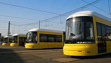
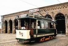
Fleet
.jpg)
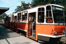
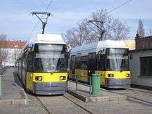
The Berlin tram has three different families of vehicles. In addition to Tatra high-floor vehicles there are low floor six-axle double articulated trams in unidirectional and bidirectional version (GT6N and GT6N-ZR), and since 2008, the new Flexity Berlin. The Tatra KT4 trams were phased out by 2017, and T6A2/B6A2 trams were phased out by 2007, those are Communism-era trams.
The number of trams has shrunk continuously. The BVB had 1,024 vehicles, while currently there are about 600. The reduction is possible because the new low-floor cars on average achieve more than twice the mileage per year (100,000 km) (62,000 mi), and, being longer, carry more passengers and therefore rarely operate in double header.
In July 2006, the cost of energy per vehicle-kilometer was:
- tram €0.33
- coupled set €0.45
- bus €0.42
- underground train €1.18[18]
GT6N
Between 1992 and 2003 45 bidirectional T6N-ZRs and 105 unidirectional GT6Ns were purchased. The cars have a width of 2.30 m (8 ft) and a length of 26.80 m (88 ft). They can carry 150 passengers and can run as coupled sets.
134 cars were in a risky transaction leased to a US investor and leased back. The SNB has accrued more than €157 million ($205 million) to hedge potential losses from cross-border business.[19]
In the end of 2011 and beginning of 2012 the SNB began the carriage 1006 and 1016 a sample exercise. They were provided with a new drive technology and new software such as the Flexcitys. The only mutually detachable vehicles had to distinguish the new car numbers 1506 and the 1516.
Flexity Berlin
In April 2005, a European tender was issued for low floor trams, half unidirectional, and half bidirectional vehicles. The latter will respond better to the BVG and construction faults and build on certain routes for cost savings. The Vienna tramway tram type ULF was tested in passenger service.
On 12 June 2006, the BVG decided to procure new trams. These are based on the tested Incentro, referred to by Bombardier as Flexity Berlin. In October 2008, for €13 million ($17 million), four prototypes were ordered and since then extensively tested. There are one- and two-way cars, respectively 30.8 (101 ft) and 40 m (131 ft) in length, carrying about 180 or 240 passengers. Use in coupled sets is not possible.
On 29 June 2009, the Supervisory Board of the BVG decided to buy 99 Flexity cars, 40 of which will be long and 59 short versions, for €305.3 million ($397.9 million). In September 2011 the first 13 long cars began to be delivered. To replace all old Tatra cars, a further 33 costing €92.3 million ($120.3 million) may need to be ordered in 2017.[20] The trams will be manufactured at Bombardier's Bautzen works or Hennigsdorf.
In June 2012 the Supervisory Board approved the BVG 2nd Serial recall of an additional 39 trams of type "Flexity Berlin". Considering the order of over 99 vehicles from 2010, that means a total of 38 vehicles and 47 long bidirectional vehicles, as well as 53 short bidirectional vehicles will be ordered from the manufacturer, Bombardier Transportation. Thus, the SNB responds to both the very positive development of passenger numbers at the tram and allows bidirectional vehicles the eventual abandonment of turning loops and enhancing the design stops. Once this procurement is secured in 2017, then the old Tatra cars can be scrapped. The State of Berlin's funded budget is €439.1 million ($572.7 million).[21]
The new cars are equipped with 2.40 m wheel spacing, 10 cm wider than the existing low-floor trams. The track width was chosen so that modifications in the network are not necessary[22] This affects only the routes, which will operate on the Flexity. Köpenick and parts of the Pankow network, the web is unable to drive.
In December 2015, BVG exercised an option for another 47 Flexity trams from Bombardier to handle increased ridership.[23]
Tram depots
Depots are required for storage and maintenance purposes. BVG has seven operational tram depots, five of which are used for storage of service trams:
- Kniprodestraße, in Friedrichshain on the east side of the junction of Kniprodestraße and Conrad-Blenkle-Straße. This depot is used for track storage and rail-grinding machinery only. It is on bus route 200, and the access tracks connect to tram line M10.
- Köpenick, on the west side of Wendenschloßstraße, south of the junction with Müggelheimer Straße. The depot entrance is on tram route 62.
- Lichtenberg, on the east side of Siegfriedstraße, north of Lichtenberg U-Bahn station. The depot entrance is on tram routes 21 & 37 and bus routes 240 & 256.
- Marzahn, on the south side of Landsberger Allee, east of Blumberger Damm. The depot has a tram stop on the M6 and 18 lines. Bus route 197 also passes the depot.
- Nalepastraße, on the east side of Nalepastraße, in Oberschöneweide. It is not on any tram or bus route, but its access line connects with tram routes M17, 21, 37, 63 and 67 at the junction of Wilhelminenhofstraße and Edisonstraße.
- Niederschönhausen, on the north-east corner of the junction of Deitzgenstraße and Schillerstraße. The line is on tram line M1. The depot is used for the storage of works machinery and historic, and preserved trams.
- Weissensee, on the north side of Bernkasteler Straße near the junction of Berliner Allee and Rennbahnstraße. The depot entrance is not directly passed by any bus or tram route, but tram routes 12 & 27 and bus routes 156, 255 & 259 serve the adjacent Berliner Allee/Rennbahnstraße tram stop.
Out-of-service trams returning to Nalepastraße and Weissensee depot remain in-service until reaching the special tram stop at each depot.
Surroundings and related systems
General view
The Berlin tram network is today the third largest in Germany
Around Berlin there are some additional tram systems that do not belong to the BVG:
- the Verkehrsbetrieb Potsdam (operators of the Potsdam Tramway)
- the Strausberg Railway (actually, a tram line located in the town of Strausberg)
- the Woltersdorf Tramway (line 87, partly in Berlin)
- the Schöneiche-Rüdersdorf Tramway (line 88, partly in Berlin)
The last three companies are located in the eastern suburbs at the eastern edge of Berlin. Each of them has only one line.
See also
References
Inline references
- 1 2 3 "The company in brief Berliner Verkehrsbetriebe". BVG. Retrieved 2015-03-05.
- 1 2 "Travel information - Overview of our lines (Metrotram)". BVG. Retrieved 2015-03-05.
- 1 2 "Travel information - Overview of our lines (Tram)". BVG. Retrieved 2015-03-05.
- 1 2 "Lines & Networks - Means of transport and lines - Tram - Trams". BVG. Archived from the original on 2014-07-27. Retrieved 2014-04-30.
- ↑ "Zahlenspiegel 2014" [Statistics 2014] (PDF) (in German). Berliner Verkehrsbetriebe (BVG). 31 December 2013. p. 2. Retrieved 2015-03-05.
- 1 2 "Berliner Straßenbahn mit langer Tradition" [Berlin Trams' Long Tradition] (in German). BVG. Retrieved 2015-03-05.
- ↑ "Wien hat das fünftgrößte Straßenbahnnetz der Welt" [Vienna has the fifth largest tramway network in the world]. www.wienerlinien.at (in German). Wiener Linien. 2011. Archived from the original on 2013-10-31. Retrieved 2013-08-31.
- ↑ Textagentur-Grimm.de: Simon Kremser
- ↑ Elfi Bendikat: Öffentliche Nahverkehrspolitik in Berlin und Paris 1839 bis 1914, p. 103, at Google Books (Walter de Gruyter), Seite 103
- ↑ http://www.ceciliengaerten-berlin.de/web/zeitrahmen/1800_1899.html Cecilengarten Berlin: Zeitrahmen
- ↑ Tram Travels: Berliner Verkehrsbetriebe (BVG)
- ↑ Wolfgang Kramer (2001), Arbeitskreis Berliner Nahverkehr e.V., ed. (in German), Linienchronik der Berliner Straßenbahn 1945–1993, Berlin
- ↑ http://www.bvg.de/de/Aktuell/Newsmeldung?newsid=380
- ↑ http://www.bvg.de/de/Aktuell/Newsmeldung?newsid=908
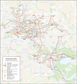
- ↑ Official BVG tramway map (PDF)
- ↑ http://travel.nationalgeographic.com/travel/top-10/trolley-rides/#page=2
- ↑ http://www.railjournal.com/index.php/light-rail/berlin-plans-major-light-rail-expansion.html Berlin plans major light rail expansion
- ↑ Small request in the Berlin parliament, printed matter 15/13611 (PDF, 128 KB)
- ↑ Peter Neumann: Now threaten heavy losses, Berliner Zeitung, 14 November 2008
- ↑ Klaus Kurpjuweit. Traffic LPP-Flexity trams; art18614, 2836566 300 million for new streetcars In: The Guardian, 1. July 2009
- ↑ http://www.bvg.de/index.php/de/103842/name/Pressemitteilungen/article/1090651.html
- ↑ Jürgen Sember, Hans-Eckhard Warns:.. Purchasing new trams for the Berlin Transport Authority - European tender - an experience report In: ZEVrail Glasers Annalen 131, 10 October 2007, pp. 395-401
- ↑ "More Flexity Berlin trams ordered". Railway Gazette. 21 December 2015.
Bibliography
Works in English and German
- Sigurd Hilkenbach, Wolfgang Kramer und Claude Jeanmaire: Berliner Straßenbahnen. Die Geschichte der Berliner Straßenbahn-Gesellschaften seit 1865 (Archive No. 6), Verlag Eisenbahn, Villigen AG (Schweiz), 1973, ISBN 3-85649-006-X
- Sigurd Hilkenbach, Wolfgang Kramer und Claude Jeanmaire: Berliner Straßenbahngeschichte II. Ein Bericht über die Entwicklung der Straßenbahn in Berlin nach 1920 (Archive No. 31), Verlag Eisenbahn, Villigen AG (Schweiz), 1977, ISBN 3-85649-031-0
- Sigurd Hilkenbach, Wolfgang Kramer und Claude Jeanmaire: Die Straßenbahnlinien im westlichen Teil Berlins. Der Wiederaufbau ab 1945 und die Stillegung im Westteil der Stadt bis 1967. (2 Bände) (Archive Nos. 46/52), Verlag Eisenbahn, Villigen AG (Schweiz), 1986, ISBN 3-85649-046-9
- Schwandl, Robert (2012). Schwandl's Tram Atlas Deutschland (in German and English) (3rd ed.). Berlin: Robert Schwandl Verlag. pp. 8–13. ISBN 9783936573336.
Works in German
- Arbeitsgemeinschaft Blickpunkt Straßenbahn e.V.: Straßenbahnatlas Deutschland 1996, Berlin, ISBN 3-926524-14-6
- Denkmalpflege-Verein Nahverkehr Berlin e.V.: Rekowagen - Die etwas härtere Art, Straßenbahn zu fahren, Verlag GVE, Berlin, 1996, ISBN 3-89218-045-8
- Denkmalpflege-Verein Nahverkehr Berlin e.V.: Historische Nahverkehrsfahrzeuge - Berlin und Brandenburg, Verlag GVE, Berlin, 2001, ISBN 3-89218-027-X
- Denkmalpflege-Verein Nahverkehr Berlin e.V.: 100 Jahre »Elektrische« in Köpenick, Verlag GVE, Berlin, 2003, ISBN 3-89218-082-2
- Sigurd Hilkenbach und Wolfgang Kramer: Die Straßenbahnen in Berlin, Alba, Düsseldorf, 1994, ISBN 3-87094-351-3
- Sigurd Hilkenbach und Wolfgang Kramer: Die Straßenbahn der Berliner Verkehrsbetriebe (BVG-Ost/BVB) 1949-1991, Transpress, Stuttgart, 1997, ISBN 3-613-71063-3
- Wolfgang Kramer und Heinz Jung: Linienchronik der Elektrischen Straßenbahn von Berlin. (2 volumes), Arbeitskreis Berliner Nahverkehr e.V., 1994 (Vol. 1), 2001 (Vol. 2)
- Holger Orb und Tilo Schütz: Straßenbahn für ganz Berlin. Geschichte - Konzeption - Städtebau, Jaron, Berlin, 2000, ISBN 3-89773-024-3
External links
| Wikimedia Commons has media related to Berlin Tramway. |
- BVG official website
- Tram network's page on BVG website
- Berlin tramway network map
- Berlin database / photo gallery and Berlin tram list at Urban Electric Transit – in various languages, including English.
- Berlin database / photo gallery at Phototrans – in various languages, including English.
This article contains information from the German-language Wikipedia article Straßenbahn Berlin.
| Baden-Württemberg |  | |
|---|---|---|
| Bavaria | ||
| Berlin | ||
| Brandenburg | ||
| Bremen | ||
| Hesse | ||
| Lower Saxony | ||
| Mecklenburg-Vorpommern | ||
| North Rhine-Westphalia | ||
| Rhineland-Palatinate | ||
| Saarland | ||
| Saxony | ||
| Saxony-Anhalt | ||
| Thuringia | ||
1 Tramway lines departing from Strasbourg
2 Tramway lines departing from Basel 3 Tramway lines departing from Berlin | ||
Urban public transport networks and systems in Germany | ||
|---|---|---|
| S-Bahn |    | |
| U-Bahn | ||
| Stadtbahn | ||
| Trams |
| |
| Trolleybuses | ||
| Suspension monorails | ||
| Other | ||
| ||