Trams in Nuremberg
| Nuremberg tramway network | |||||||||||||||||||||||||
|---|---|---|---|---|---|---|---|---|---|---|---|---|---|---|---|---|---|---|---|---|---|---|---|---|---|
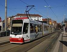 A GT6N tram in Friedrich-Ebert-Platz, 2012. | |||||||||||||||||||||||||
| Operation | |||||||||||||||||||||||||
| Locale | Nuremberg, Bavaria, Germany | ||||||||||||||||||||||||
| |||||||||||||||||||||||||
| |||||||||||||||||||||||||

The Nuremberg tramway network (German: Straßenbahnnetz Nürnberg) is a network of tramways forming part of the public transport system in Nuremberg, a city in the federal state of Bavaria, Germany.
The network is operated by Verkehrs-Aktiengesellschaft Nürnberg (VAG), which is a member of the VGN (Verkehrsverbund Großraum Nürnberg or Greater Nuremberg Transport Network).
As of 2013, the network consisted of five lines,[1] running on a total operational route length of 33 kilometres (21 mi).[3] The network carried 39.152 million passengers annually.
History
The first horse-drawn tramline opened in Nuremberg on 25 August 1881.[4]
Electrification came to the system when the first electric tramline opened on 7 May 1896.[4] The entire system was electrified on 20 July 1898.[4] Until the 1990s the track gauge was 1,432 mm (4 ft 8 3⁄8 in).
Lines
The Nuremberg tramway network operated on six lines until 2011,[3] when two tram lines were joined.
The network is made up of 96 kilometres (60 mi) of track,[2] with a total route length of 37 kilometres (23 mi),[2] of which 33 kilometres (21 mi)[2] is operational route. Of the tram's operational route, 41% is tramline segregated from other traffic, with the other 59% representing trams operating in the street with other automobile traffic.[2]
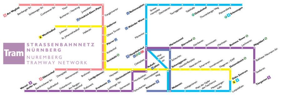
The Nuremberg tramway network is made up of the following five lines:[1]
| Line | Route (crossing points and termini) | Stops |
|---|---|---|
| 4 | Gibitzenhof – Landgrabenstraße – Hallertor – Friedrich-Ebert-Platz – Am Wegfeld | 19 |
| 5 | Tiergarten – Mögeldorf – Marientunnel – Hauptbahnhof - Aufseßplatz - Frankenstraße - Südfriedhof | 26 |
| 6 | Doku-Zentrum – Dutzendteich – Schweiggerstraße – Christuskirche – Landgrabenstraße – Hallertor – Westfriedhof | 22 |
| 8 | Tristanstraße - Hauptbahnhof – Rathenauplatz – Erlenstegen | 17 |
| 9 | Doku-Zentrum – Wodanstraße – Schweiggerstraße – Hauptbahnhof | 9 |
Expansion plans
After a 2016 ballot measure in Erlangen, the section to am Wegfeld is planned to be extended to Erlangen and from there to Herzogenaurach in a roughly L-shaped line. Herzogenaurach previously had a connection to mainline rail, but it was shut down in the 1980s, leaving it one of southern Germany's biggest cities without a rail connection.
See also
References
Notes
- 1 2 3 "Straßenbahn Stadtverkehr Nürnberg" [Tramline traffic (lines) Nuremberg] (in German). VGN. Retrieved 2013-10-03.
- 1 2 3 4 5 6 "Wussten Sie? - Wussten Sie zum Thema "Straßenbahn"" [Did you know? - Facts about the Tram] (in German). VAG. Retrieved 2013-10-03.
- 1 2 3 4 "Geschäftsbericht 2012 Ziele erreichen – auf ganzer Strecke" [Annual Report 2012 Targets achieved - over the whole distance] (PDF) (in German). VAG. June 2013. p. 2. Archived from the original (PDF) on 2013-10-05. Retrieved 2013-10-03.
- 1 2 3 "125 Jahre Nahverkehr in Nürnberg: Am 25. August 1881 fuhr die erste Pferdebahn" [125 years suburban traffic in Nuremberg: On 25 August 1881, the first horse tram line] (in German). VAG. Archived from the original on 5 October 2013. Retrieved 2013-10-03.
Bibliography
- Binder, Robert; et al. (1986). Der Stadtverkehr in Nürnberg und Fürth von 1881 bis 1981 [City Transport in Nuremberg and Fürth from 1881 to 1981] (in German). Nürnberg: Presse- und Öffentlichkeitsstelle der VAG.
- Hendlemeier, Wolfgang (1981). Handbuch der deutschen Straßenbahngeschichte [Handbook of German Tram History] (in German). 1. München.
- Höltge, Dieter; Kochems, Michael (2006). Straßen- und Stadtbahnen in Deutschland [Tramways and Stadtbahnen in Germany]. Band 10: Bayern [Volume 10: Bavaria]. Freiburg i. B., Germany: EK-Verlag. ISBN 388255391X. (in German)
- Klebes, Günther (1980). Die Strassenbahnen Bayerns in alten Ansichten [The Trams of Bavaria in Old Postcards] (in German). Zaltbommel. ISBN 90-288-1197-4.
- Schwandl, Robert (2012). Schwandl's Tram Atlas Deutschland (in German and English) (3rd ed.). Berlin: Robert Schwandl Verlag. pp. 110–113. ISBN 9783936573336.
- Der Nahverkehr in Nürnberg und Fürth von 1982 bis 2008 [Local Transport in Nuremberg and Fürth from 1982 to 2008] (in German) (1 ed.). Nürnberg: Jürgen Heußner. 2009.
- 125 Jahre Nahverkehr in Nürnberg [125 Years Local Transport in Nuremberg] (in German) (1 ed.). Nürnberg: Presse- und Öffentlichkeitsstelle der VAG. 2006. ISBN 978-3-00-018689-9.
- Nürnberg-Fürther Straßenbahn im Wandel der Zeiten [Nürnberg-Fürther Straßenbahn through the Ages] (in German) (3 ed.). Nürnberg: Freunde der Nürnberg-Fürther Straßenbahn e. V. 2005.
External links
![]()
- Nürnberg database / photo gallery and Nürnberg tram list at Urban Electric Transit – in various languages, including English.
- Nürnberg database / photo gallery at Phototrans – in various languages, including English.
| Baden-Württemberg |  | |
|---|---|---|
| Bavaria | ||
| Berlin | ||
| Brandenburg | ||
| Bremen | ||
| Hesse | ||
| Lower Saxony | ||
| Mecklenburg-Vorpommern | ||
| North Rhine-Westphalia | ||
| Rhineland-Palatinate | ||
| Saarland | ||
| Saxony | ||
| Saxony-Anhalt | ||
| Thuringia | ||
1 Tramway lines departing from Strasbourg
2 Tramway lines departing from Basel 3 Tramway lines departing from Berlin | ||
Urban public transport networks and systems in Germany | ||
|---|---|---|
| S-Bahn |    | |
| U-Bahn | ||
| Stadtbahn | ||
| Trams |
| |
| Trolleybuses | ||
| Suspension monorails | ||
| Other | ||
| ||