Spandau
| Spandau | ||
|---|---|---|
| Borough of Berlin | ||
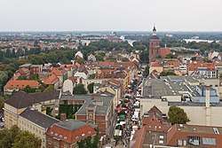 Old town of Spandau | ||
| ||
 Spandau Location of Spandau in Berlin .svg.png) | ||
| Coordinates: 52°33′N 13°12′E / 52.550°N 13.200°ECoordinates: 52°33′N 13°12′E / 52.550°N 13.200°E | ||
| Country | Germany | |
| State | Berlin | |
| City | Berlin | |
| Government | ||
| • Mayor | Helmut Kleebank (SPD) | |
| Area | ||
| • Total | 91.91 km2 (35.49 sq mi) | |
| Population (2012-11-30) | ||
| • Total | 231,540 | |
| • Density | 2,500/km2 (6,500/sq mi) | |
| Time zone | CET/CEST (UTC+1/+2) | |
| Vehicle registration | B | |
| Website | Official homepage | |

Spandau (pronounced [ˈʃpandaʊ̯]) is the westernmost of the twelve boroughs (Bezirke) of Berlin, situated at the confluence of the Havel and Spree rivers and extending along the western bank of Havel. It is the smallest borough by population, but the fourth largest by land area.
Overview
Modern industries in Spandau include metal working, and chemical, and electrical factories. BMW Motorrad's Spandau factory made all BMW motorcycles from 1969 until final assembly plants were added in Rayong, Thailand in 2000, and Manaus, Brazil in 2016.[1][2][3]
Rathaus Spandau, Spandau's seat of government, was built in 1913. Other landmarks include the Renaissance fortress Spandau Citadel, built in 1594, the 1848 St. Marien am Behnitz Catholic church designed by August Soller, and Spandau arsenal, Germany's arms development center until 1919, now a museum. That arsenal's Spandau machine gun inspired the slang Spandau Ballet to describe dying soldiers on barbed wire during the First World War, and later was applied to the appearance of Nazi war criminals hanged at Spandau Prison.
In 1979, the English New Romantic band Spandau Ballet again re-purposed the term for its name. The notorious prison, built in 1876, held Nazi war criminals after World War II until 1987, when it was demolished after the death of the last surviving prisoner, Rudolf Hess.[4]
Geography
Spandau's neighbors outside Berlin are the districts (Kreis) of Oberhavel to the north, and Havelland to the west, and the city of Potsdam, Brandenburg, to the southwest. Within Berlin, it borders the boroughs of Steglitz-Zehlendorf to the south, Charlottenburg-Wilmersdorf to the west, and Reinickendorf to the northwest. Its land area of 91.91 km2 (35.49 sq mi) is the fourth largest of the twelve boroughs.
Subdivisions
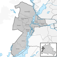
Spandau Borough is divided into 9 quarters (Ortsteile):
Demographics
As of 2010, Spandau had a population of 223,962, the smallest of the twelve boroughs. There were 62,000 migrants or other non-ethnic Germans, comprising 27% of Spandau's population.[5]
| Percentage of people with migration background[5] | |
|---|---|
| Germans without migration background/Ethnic Germans | 165,000 (73%) |
| Germans with migration background or foreign citizens | 62,000 (27%) |
| Middle Eastern origin (Turkey, Arab League, Iran etc.) | 20,400 (9%) |
| (non-German) EU-European migration background (esp. Poles, Romanians etc.) | 13,600 (6%) |
| African background/Afro-Germans (Ghana, Nigeria, Kamerun etc.) | 7,000 (3%) |
| Others (East Asians, Russians, Serbs etc.) | 20,400 (9%) |
Politics
.svg.png)
At the 2016 elections for the parliament of the borough (Bezirksverordnetenversammlung) the following parties were elected:
People
- Bela B., musician, born 14 December 1962
- Robert Hoyzer, former football referee, born 28 August 1979
- Ivan Rebroff, singer, born 31 July 1931, died 27 February 2008 in Frankfurt
- Erna Sack, soprano, born 6 February 1898, died 2 March 1972 in Mainz
- Henning Alexander von Kleist, Governor of the Spandau citatel, died there in 1784
Twin towns
Spandau's town twinning (Sister City) partners are:


See also
References
- ↑ "my FB Title". Be.berlin.de. Retrieved 17 January 2018.
- ↑ Henry, Ian (6 January 2015). "BMW: Global growth". Automotive Manufacturing Solutions. Ultima Media. Retrieved 17 January 2018.
- ↑ "BMW Motorrad expands production network with its own manufacturing site in Brazil. [press release]". BMW Group. 4 April 2016. Retrieved 17 January 2018.
- ↑ Goda, Norman J. W. (2006). Tales from Spandau. University of Florida. ISBN 978-0-521-86720-7.
- 1 2 "Melderechtlich registrierte Einwohner im Land Berlin" (PDF). Statistik-berlin-brandenburg.de. 31 December 2010. Retrieved 17 January 2018.
External links
| Wikimedia Commons has media related to Spandau. |
- (in German) Official Homepage
- Official homepage of Berlin
- "Unterwegs in Spandau": Sehenswürdigkeiten, News, Veranstaltungshinweise und Berichte aus Spandau
| |
| West boroughs (1920–2000) | 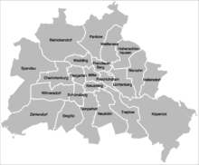 | |
|---|---|---|
| East boroughs (1920–2000) |
| |