Trams in Plauen
| Plauen tramway network | |||
|---|---|---|---|
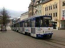 A pair of Plauen trams in the Bahnhofstraße. | |||
| Operation | |||
| Locale | Plauen, Saxony, Germany | ||
| Open | 17 November 1894 | ||
| Status | Operational | ||
| Lines | 5 | ||
| Operator(s) |
| ||
| Infrastructure | |||
| Track gauge | 1,000 mm (3 ft 3 3⁄8 in) | ||
| Propulsion system(s) | Electricity | ||
| Electrification | 600 V DC | ||
| |||
| Website | Plauener Straßenbahn GmbH (PSB) (in German) | ||
The Plauen tramway network (German: Straßenbahnnetz Plauen) is a network of tramways forming part of the public transport system in Plauen, a city in the federal state of Saxony, Germany.
Opened in 1894, the network has been operated since 1990 by Plauener Straßenbahn GmbH (PSB).
Lines
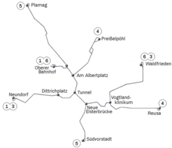
As of 2013, the network had the following lines:
| Line | Route | Length | Journey time |
|---|---|---|---|
| 1 | Neundorf – Dittrichplatz – Tunnel – Am Albertplatz – Oberer Bahnhof | 6.5 km | 20–24 min |
| 3 | Neundorf – Dittrichplatz – Tunnel – Neue Elsterbrücke – Vogtlandklinkium – Waldfrieden | 6.4 km | 20–22 min |
| 4 | Preißelpöhl – Am Albertplatz – Tunnel – Neue Elsterbrücke – Vogtlandklinkium – Reusa | 6.0 km | 21–23 min |
| 5 | Südvorstadt – Neue Elsterbrücke – Tunnel – Am Albertplatz – Plamag | 3.6 km | 12–15 min |
| 6 | Waldfrieden – Vogtlandklinkium – Neue Elsterbrücke – Tunnel – Am Albertplatz – Oberer Bahnhof | 7.6 km | 22–27 min |
See also
References
- Bauer, Gerhard; Kuschinski, Norbert (1993). Die Straßenbahnen in Ostdeutschland [The Tramways in East Germany]. Band 1: Sachsen [Volume 1: Saxony]. Aachen, Germany: Schweers + Wall. ISBN 3921679796. (in German)
- Schwandl, Robert (2012). Schwandl's Tram Atlas Deutschland (in German and English) (3rd ed.). Berlin: Robert Schwandl Verlag. pp. 114–115. ISBN 9783936573336.
External links
![]()
- Plauen database / photo gallery and Plauen tram list at Urban Electric Transit – in various languages, including English.
- Plauen database / photo gallery at Phototrans – in various languages, including English.
| Baden-Württemberg |  | |
|---|---|---|
| Bavaria | ||
| Berlin | ||
| Brandenburg | ||
| Bremen | ||
| Hesse | ||
| Lower Saxony | ||
| Mecklenburg-Vorpommern | ||
| North Rhine-Westphalia | ||
| Rhineland-Palatinate | ||
| Saarland | ||
| Saxony | ||
| Saxony-Anhalt | ||
| Thuringia | ||
1 Tramway lines departing from Strasbourg
2 Tramway lines departing from Basel 3 Tramway lines departing from Berlin | ||
Urban public transport networks and systems in Germany | ||
|---|---|---|
| S-Bahn |    | |
| U-Bahn | ||
| Stadtbahn | ||
| Trams |
| |
| Trolleybuses | ||
| Suspension monorails | ||
| Other | ||
| ||
Coordinates: 50°29′48″N 12°08′10″E / 50.49667°N 12.13611°E
This article is issued from
Wikipedia.
The text is licensed under Creative Commons - Attribution - Sharealike.
Additional terms may apply for the media files.