Strausberg
| Strausberg | ||
|---|---|---|
.jpg) Panoramic view from Straussee lake | ||
| ||
 Strausberg Locator map in Märkisch-Oderland 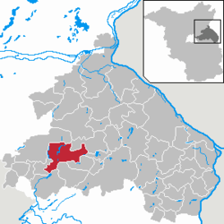 | ||
| Coordinates: 52°35′00″N 13°53′00″E / 52.58333°N 13.88333°ECoordinates: 52°35′00″N 13°53′00″E / 52.58333°N 13.88333°E | ||
| Country | Germany | |
| State | Brandenburg | |
| District | Märkisch-Oderland | |
| Government | ||
| • Mayor | Elke Stadeler ([1]) | |
| Area | ||
| • Total | 67.86 km2 (26.20 sq mi) | |
| Elevation | 94 m (308 ft) | |
| Population (2017-12-31)[2] | ||
| • Total | 26,522 | |
| • Density | 390/km2 (1,000/sq mi) | |
| Time zone | CET/CEST (UTC+1/+2) | |
| Postal codes | 15344 | |
| Dialling codes | 03341 | |
| Vehicle registration | MOL, FRW, SEE, SRB | |
| Website | Stadt Strausberg | |

Strausberg is a town in Brandenburg, Germany, located 30 km east of Berlin. With a population of 25,594 it is the largest town in the district of Märkisch-Oderland.
History
Strausberg was founded around 1240 and in 1333 its first town hall was built. Today an historic defensive wall borders the old town. In the 19th century industrialization took place and the town developed a local labour movement, including union structures and a local branch of both the Social Democratic and the Communist Party of Germany.[3] After 1945, the town became part of East Germany. Strausberg was the administrative seat of the Strausberg district until a 1993 merger with Bad Freienwalde and Seelow formed "Märkisch-Oderland" with Seelow becoming the new administrative seat of the district.
Geography
Overview
Strausberg is 30 km east of Berlin (from the district of Marzahn-Hellersdorf) and 30 km to the west of Kostrzyn, at the Polish border. It is part of Berlin/Brandenburg Metropolitan Region and a middle center (Mittelzentrum) of it. Its bordering municipalities are, listed in a clockwise sense starting from north, Altlandsberg, Oberbarnim, Buckow, Garzau-Garzin, Rehfelde, Rüdersdorf and Petershagen-Eggersdorf.
Subdivision
The town is divided into nine boroughs (Gebiet): Fasanenpark, Gartenstadt, Hegermühle, Neue Mühle, Postbruch, Schillerhöhe (with the Spitzmühle), Strausberg Nord, Strausberg Stadt and Vorstadt. The municipality has three hamlets (Ortsteile):
- Gladowshöhe (217 inhabitants[4])
- Hohenstein (233 inhabitants[4])
- Ruhlsdorf (44 inhabitants[4])
Demography
After an increase of population since the Second World War, Strausberg has stopped its "growth" remaining at almost 26,000 inhabitants in last one, with a little decrease in early years of 2000. Forecasts, however, show a considerable decline within the next two decades. Details see sources of the following graphics.
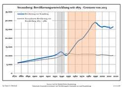 Development of Population since 1875 within the Current Boundaries (Blue Line: Population; Dotted Line: Comparison to Population Development of Brandenburg state; Grey Background: Time of Nazi rule; Red Background: Time of Communist rule)
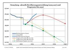 Recent Population Development and Projections (Population Development before Census 2011 (blue line); Recent Population Development according to the Census in Germany in 2011 (blue bordered line); Projection by the Brandenburg state for 2005-2030 (yellow line); Projection by the Brandenburg state for 2014-2030 (red line); Projection by the Bertelsmann Foundation for 2012-2030 (green line)
| Strausberg: Population development within the current boundaries (2017)[5] | ||||||||||||||||||||||||||||||||||||||||||||||||||||||||||||||||||||||||||||||||||||||||||||||||||||||||||||||||||||||||||||||||||||||
|---|---|---|---|---|---|---|---|---|---|---|---|---|---|---|---|---|---|---|---|---|---|---|---|---|---|---|---|---|---|---|---|---|---|---|---|---|---|---|---|---|---|---|---|---|---|---|---|---|---|---|---|---|---|---|---|---|---|---|---|---|---|---|---|---|---|---|---|---|---|---|---|---|---|---|---|---|---|---|---|---|---|---|---|---|---|---|---|---|---|---|---|---|---|---|---|---|---|---|---|---|---|---|---|---|---|---|---|---|---|---|---|---|---|---|---|---|---|---|---|---|---|---|---|---|---|---|---|---|---|---|---|---|---|---|
|
|
| ||||||||||||||||||||||||||||||||||||||||||||||||||||||||||||||||||||||||||||||||||||||||||||||||||||||||||||||||||||||||||||||||||||
Tourism
Strausberg covers an area of 68 km2. Over 750 years old, it has a population of approx. 26,300 (the largest in its district). There are over 1500 businesses and 100 km of footpath. It is known as "Die grüne Stadt am See" (the green town by the lake). Strausberg's forest and lakes are attractive, family friendly, and great for sporting. Its biggest lake is the "Straussee", located between the town and the biggest forest, the "Strausberger Wald". The forest and water protection nurtures a unique environment.
Transport
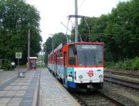
The town is served by Strausberg railway station, situated some 6 kilometres (3.7 mi) to the south of the city, which is on the Berlin S-Bahn Line 5 and Deutsche Bahn's Berlin Lichtenberg - Kostrzyn service. There are three other stops on the S5 line within the city, these being Strausberg Hegermühle, Strausberg Stadt and Strausberg Nord.

Strausberg is also served by the Strausberg Railway (Strausberger Eisenbahn), a light rail line with 9 stops, which connects the main railway station to the centre of town. Besides the main railway station, the other 8 stops are: Landhausstraße, Schlagmühle, Stadtwald, Hegermühle, Wolfstal, Käthe-Kollwitz-Straße, Elisabethstraße and Lustgarten, the northern terminus. The Strausberg Railway also operates the Straussee Ferry (Strausseefähre), an unusual electrically operated passenger cable ferry across the Straussee.
The town has also a small aerodrome ("Flugplatz Strausberg", ICAO : EDAY),[6] opened in 1927, with a runway of 1.200 m × 28 m, and situated 2 kilometers in the east of town center.
Sport
The local football representative is the FC Strausberg, competing in "Verbandsliga Brandenburg". Home games of FCS are played at the "Energiearena" stadium.
Photogallery
 Aerial view
 Old city wall
 The "Straussee"
 "Strausberger Wald" and the lake
Partnerships
Twin towns
.svg.png)


Other kind of twinnages
- Hertha BSC
- Bundeswehr [7] (2001)
Notable residents
- Andreas Angelus (1561–1598)
- Michael Gartenschläger (1944–1976)
- Johannes Haw (1871–1949)
- Sigmund Jähn (b. 1937)
- Siegfried Kasche (1903–1947), Nazi Storm Trooper officer and ambassador executed for war crimes
References
- ↑ Independent of PDS + SPD group
- ↑ "Bevölkerung im Land Brandenburg nach amtsfreien Gemeinden, Ämtern und Gemeinden 31. Dezember 2017 (Fortgeschriebene amtliche Einwohnerzahlen auf Grundlage des Zensus 2011)". Amt für Statistik Berlin-Brandenburg (in German). 2018.
- ↑ Horst Klein: Zur Geschichte der Ortsgruppe der KPD Strausberg 1920 bis 1946 (Thesen), in: Jahrbuch für Forschungen zur Geschichte der Arbeiterbewegung, No. I/2002; and Horst Klein: 110 Jahre organisierte Arbeiterbewegung - 1887–1997 Sozialdemokraten in Strausberg (Thesen), in: Jahrbuch für Forschungen zur Geschichte der Arbeiterbewegung, No. II/2003.
- 1 2 3 (in German) Infos about inhabitants as of 31-12-2007 Archived 2010-06-02 at the Wayback Machine.
- ↑ Detailed data sources are to be found in the Wikimedia Commons.Population Projection Brandenburg at Wikimedia Commons
- ↑ (in German) Infos on strausberger aerodrome's official site
- ↑ "Federal Defence", BW at the location of Strausberg
Bibliography
- Rolf Barthel, Michael Haddenhorst: Städte in Deutschland - Strausberg. Nicolaische Verlagsbuchhandlung, Beuermann GmbH, Berlin 1993 ISBN 3-87584-483-1
- Horst Klein: Zur Geschichte der Ortsgruppe der KPD Strausberg 1920 bis 1946 (Thesen), in: Jahrbuch für Forschungen zur Geschichte der Arbeiterbewegung, No. I/2002.
- Horst Klein: 110 Jahre organisierte Arbeiterbewegung - 1887–1997 Sozialdemokraten in Strausberg (Thesen), in: Jahrbuch für Forschungen zur Geschichte der Arbeiterbewegung, No. II/2003.
External links
| Wikimedia Commons has media related to Strausberg. |
- (in German) Strausberg.de
- (in German) Stadt-Strausberg.de
- (in German) Strausberg-Live
- (in German) FC Strausberg
- (in German) Strausberger Eisenbahn (urban railway)
- (in German) Stadtwiki Strausberg
- (in English) Map of railways in Strausberg on www.urbanrail.net