Tourrette-Levens
| Tourrette-Levens | ||
|---|---|---|
| Commune | ||
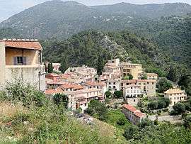 A view of Tourrette-Levens from the castle | ||
| ||
 Tourrette-Levens Location within Provence-A.-C.d'A. region  Tourrette-Levens | ||
| Coordinates: 43°47′15″N 7°16′36″E / 43.7875°N 7.2767°ECoordinates: 43°47′15″N 7°16′36″E / 43.7875°N 7.2767°E | ||
| Country | France | |
| Region | Provence-Alpes-Côte d'Azur | |
| Department | Alpes-Maritimes | |
| Arrondissement | Nice | |
| Canton | Tourrette-Levens | |
| Intercommunality | Métropole Nice Côte d'Azur | |
| Government | ||
| • Mayor (2008–2014) | Alain Frère | |
| Area1 | 16.5 km2 (6.4 sq mi) | |
| Population (2008)2 | 4,728 | |
| • Density | 290/km2 (740/sq mi) | |
| Demonym(s) | Tourrettans | |
| Time zone | UTC+1 (CET) | |
| • Summer (DST) | UTC+2 (CEST) | |
| INSEE/Postal code | 06147 /06690 | |
| Elevation |
160–845 m (525–2,772 ft) (avg. 390 m or 1,280 ft) | |
|
1 French Land Register data, which excludes lakes, ponds, glaciers > 1 km2 (0.386 sq mi or 247 acres) and river estuaries. 2 Population without double counting: residents of multiple communes (e.g., students and military personnel) only counted once. | ||
.svg.png)
Tourrette-Levens is a commune in the Alpes-Maritimes department in southeastern France.
Population
| Historical population | ||
|---|---|---|
| Year | Pop. | ±% |
| 1962 | 2,035 | — |
| 1968 | 2,650 | +30.2% |
| 1975 | 2,644 | −0.2% |
| 1982 | 3,004 | +13.6% |
| 1990 | 3,412 | +13.6% |
| 1999 | 4,116 | +20.6% |
| 2008 | 4,728 | +14.9% |
Tourism
Tourrette-Levens is one of sixteen villages grouped together by the Métropole Nice Côte d'Azur tourist department as the Route des Villages Perchés (Route of Perched Villages). The others are: Aspremont, Carros, Castagniers, Coaraze, Colomars, Duranus, Èze, Falicon, La Gaude, Lantosque, Levens, La Roquette-sur-Var, Saint-Blaise, Saint-Jeannet and Utelle.[1]
See also
References
External links
- ↑ "The route of perched villages" (PDF). Métropole Nice Côte d'Azur. 2013.
| Wikimedia Commons has media related to Tourrette-Levens. |
| Authority control |
|---|
This article is issued from
Wikipedia.
The text is licensed under Creative Commons - Attribution - Sharealike.
Additional terms may apply for the media files.