Saint-André-de-la-Roche
| Saint-André-de-la-Roche | ||
|---|---|---|
| Commune | ||
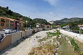 A view of the river flowing through the village | ||
| ||
 Saint-André-de-la-Roche Location within Provence-A.-C.d'A. region  Saint-André-de-la-Roche | ||
| Coordinates: 43°44′28″N 7°17′18″E / 43.7411°N 7.2883°ECoordinates: 43°44′28″N 7°17′18″E / 43.7411°N 7.2883°E | ||
| Country | France | |
| Region | Provence-Alpes-Côte d'Azur | |
| Department | Alpes-Maritimes | |
| Arrondissement | Nice | |
| Canton | Nice-7 | |
| Intercommunality | Métropole Nice Côte d'Azur | |
| Government | ||
| • Mayor (2008–2014) | Honoré Colomas | |
| Area1 | 2.86 km2 (1.10 sq mi) | |
| Population (2008)2 | 4,841 | |
| • Density | 1,700/km2 (4,400/sq mi) | |
| Demonym(s) | Saint-Andréens | |
| Time zone | UTC+1 (CET) | |
| • Summer (DST) | UTC+2 (CEST) | |
| INSEE/Postal code | 06114 /06730 | |
| Elevation |
43–383 m (141–1,257 ft) (avg. 62 m or 203 ft) | |
|
1 French Land Register data, which excludes lakes, ponds, glaciers > 1 km2 (0.386 sq mi or 247 acres) and river estuaries. 2 Population without double counting: residents of multiple communes (e.g., students and military personnel) only counted once. | ||
.svg.png)
Saint-André-de-la-Roche is a commune in the Alpes-Maritimes department in southeastern France.
Population
| Historical population | ||
|---|---|---|
| Year | Pop. | ±% |
| 1962 | 1,821 | — |
| 1968 | 2,006 | +10.2% |
| 1975 | 4,397 | +119.2% |
| 1982 | 4,264 | −3.0% |
| 1990 | 4,151 | −2.7% |
| 1999 | 4,122 | −0.7% |
| 2008 | 4,841 | +17.4% |
See also
References
| Wikimedia Commons has media related to Saint-André-de-la-Roche. |
This article is issued from
Wikipedia.
The text is licensed under Creative Commons - Attribution - Sharealike.
Additional terms may apply for the media files.