Valdeblore
| Valdeblore | ||
|---|---|---|
| Commune | ||
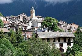 A view of La Bolline, in Valdebore, with the bell tower of the chapel of the Pénitents Blancs | ||
| ||
 Valdeblore Location within Provence-A.-C.d'A. region  Valdeblore | ||
| Coordinates: 44°04′19″N 7°10′19″E / 44.0719°N 7.1719°ECoordinates: 44°04′19″N 7°10′19″E / 44.0719°N 7.1719°E | ||
| Country | France | |
| Region | Provence-Alpes-Côte d'Azur | |
| Department | Alpes-Maritimes | |
| Arrondissement | Nice | |
| Canton | Tourrette-Levens | |
| Intercommunality | Métropole Nice Côte d'Azur | |
| Government | ||
| • Mayor (2008–2014) | Fernand Blanchi | |
| Area1 | 94.16 km2 (36.36 sq mi) | |
| Population (2008)2 | 831 | |
| • Density | 8.8/km2 (23/sq mi) | |
| Time zone | UTC+1 (CET) | |
| • Summer (DST) | UTC+2 (CEST) | |
| INSEE/Postal code | 06153 /06420 | |
| Elevation |
399–2,880 m (1,309–9,449 ft) (avg. 1,050 m or 3,440 ft) | |
|
1 French Land Register data, which excludes lakes, ponds, glaciers > 1 km2 (0.386 sq mi or 247 acres) and river estuaries. 2 Population without double counting: residents of multiple communes (e.g., students and military personnel) only counted once. | ||
.svg.png)
Valdeblore is a commune in the Alpes-Maritimes department in the Provence-Alpes-Côte d'Azur region in southeastern France.
Population
| Historical population | ||
|---|---|---|
| Year | Pop. | ±% |
| 1962 | 556 | — |
| 1968 | 556 | +0.0% |
| 1975 | 466 | −16.2% |
| 1982 | 584 | +25.3% |
| 1990 | 664 | +13.7% |
| 1999 | 686 | +3.3% |
| 2008 | 831 | +21.1% |
See also
References
| Wikimedia Commons has media related to Valdeblore. |
| Authority control |
|---|
This article is issued from
Wikipedia.
The text is licensed under Creative Commons - Attribution - Sharealike.
Additional terms may apply for the media files.