Pégomas
| Pégomas | ||
|---|---|---|
| Commune | ||
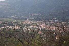 A general view of Pégomas | ||
| ||
 Pégomas Location within Provence-A.-C.d'A. region  Pégomas | ||
| Coordinates: 43°35′51″N 6°56′02″E / 43.5975°N 06.9339°ECoordinates: 43°35′51″N 6°56′02″E / 43.5975°N 06.9339°E | ||
| Country | France | |
| Region | Provence-Alpes-Côte d'Azur | |
| Department | Alpes-Maritimes | |
| Arrondissement | Grasse | |
| Canton | Mandelieu-la-Napoule | |
| Intercommunality | Pôle Azur Provence | |
| Government | ||
| • Mayor (2008–2014) | Gilbert Pibou | |
| Area1 | 11.28 km2 (4.36 sq mi) | |
| Population (2008)2 | 6,438 | |
| • Density | 570/km2 (1,500/sq mi) | |
| Time zone | UTC+1 (CET) | |
| • Summer (DST) | UTC+2 (CEST) | |
| INSEE/Postal code | 06084 /06580 | |
| Elevation | 6–483 m (20–1,585 ft) | |
|
1 French Land Register data, which excludes lakes, ponds, glaciers > 1 km2 (0.386 sq mi or 247 acres) and river estuaries. 2 Population without double counting: residents of multiple communes (e.g., students and military personnel) only counted once. | ||

Pégomas is a commune in the Alpes-Maritimes department in southeastern France.
Population
| Historical population | ||
|---|---|---|
| Year | Pop. | ±% |
| 1982 | 3,452 | — |
| 1990 | 4,618 | +33.8% |
| 1999 | 5,794 | +25.5% |
| 2008 | 6,438 | +11.1% |
See also
References
| Wikimedia Commons has media related to Pégomas. |
This article is issued from
Wikipedia.
The text is licensed under Creative Commons - Attribution - Sharealike.
Additional terms may apply for the media files.