Sigale
| Sigale | ||
|---|---|---|
| Commune | ||
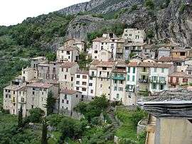 A general view of Sigale | ||
| ||
 Sigale Location within Provence-A.-C.d'A. region  Sigale | ||
| Coordinates: 43°52′24″N 6°57′55″E / 43.8733°N 6.9653°ECoordinates: 43°52′24″N 6°57′55″E / 43.8733°N 6.9653°E | ||
| Country | France | |
| Region | Provence-Alpes-Côte d'Azur | |
| Department | Alpes-Maritimes | |
| Arrondissement | Nice | |
| Canton | Vence | |
| Intercommunality | Vallée de l'Estéron | |
| Government | ||
| • Mayor (2008–2014) | Arnaud Prigent | |
| Area1 | 5.62 km2 (2.17 sq mi) | |
| Population (2008)2 | 210 | |
| • Density | 37/km2 (97/sq mi) | |
| Time zone | UTC+1 (CET) | |
| • Summer (DST) | UTC+2 (CEST) | |
| INSEE/Postal code | 06135 /06910 | |
| Elevation |
327–1,108 m (1,073–3,635 ft) (avg. 630 m or 2,070 ft) | |
|
1 French Land Register data, which excludes lakes, ponds, glaciers > 1 km2 (0.386 sq mi or 247 acres) and river estuaries. 2 Population without double counting: residents of multiple communes (e.g., students and military personnel) only counted once. | ||

Sigale is a commune in the Alpes-Maritimes department in southeastern France.
Population
| Historical population | ||
|---|---|---|
| Year | Pop. | ±% |
| 1701 | 980 | — |
| 1754 | 450 | −54.1% |
| 1790 | 550 | +22.2% |
| 1962 | 138 | −74.9% |
| 1968 | 112 | −18.8% |
| 1975 | 155 | +38.4% |
| 1982 | 145 | −6.5% |
| 1990 | 160 | +10.3% |
| 1999 | 181 | +13.1% |
| 2008 | 210 | +16.0% |
See also
References
| Wikimedia Commons has media related to Sigale. |
This article is issued from
Wikipedia.
The text is licensed under Creative Commons - Attribution - Sharealike.
Additional terms may apply for the media files.