Tottenville, Staten Island
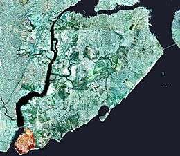
Tottenville is the southernmost neighborhood of Staten Island, New York City and New York State, with an area of approximately 1.7 square miles (4.4 km2). Originally named Bentley Manor by one of its first settlers, Captain Christopher Billop (1638–1726), after a small ship he owned named the Bentley, the district was renamed Tottenville in 1869, apparently in honor of the locally prominent Totten family, whose name can be seen on tombstones in one of the earliest churches, Bethel Methodist Church, on Amboy Road. The neighborhood is represented in the New York City Council by Joe Borelli and in the New York State Assembly by Ronald Castorina, Jr.
History
Early history
The Raritan band of the Unami Indians, a branch of the Lenape or Delaware nation, were the original inhabitants of all Staten Island, including Tottenville. The largest pre-European burial ground known as Burial Ridge, is located in Conference House Park.

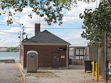
_(NYPL_b15279351-105073).tiff.jpg)

During the colonial period and for a significant time thereafter, Tottenville was an important waypoint for travelers between New York City—of which Staten Island did not formally become a part until 1898—and Philadelphia, as it was the site of a ferry that crossed the Arthur Kill to the Ferry Slip in Perth Amboy, New Jersey. The ferry became less important when the Outerbridge Crossing opened in 1928, but continued to operate until 1963.
Two distinctive landmarks stand at the northern approaches to the neighborhood: the Bethel United Methodist Church, erected in 1840 and rebuilt on the same site in 1886 after a fire destroyed the original structure; and an abandoned factory originally built in 1900 as Nassau Smelting's plant that was later used for recycling by Lucent Technologies (closed 2001). Tottenville is bounded on the west and south by the Arthur Kill, and on the east by Raritan Bay, the mouth of which lies immediately to the south of Arthur Kill's entry to the bay (which is also sometimes reckoned as being part of the Atlantic Ocean). The Conference House was built by Christopher Billop and so named because it was the site of unsuccessful negotiations to end the American Revolutionary War in 1776. The home is now the centerpiece of the city park of the same name. The Billop family, who built the estate in 1678, continued to own it and the surrounding property during the 1776 meeting, but their land was confiscated in 1784 because family members had been Tories during the war.
Many small factories once dotted the neighborhood's western shoreline, but most are no longer in operation. Boat construction also once flourished along the shoreline, but the industry was rendered obsolete in 1900 when boats began being constructed of steel rather than wood. World War I spawned a revival of shipbuilding activity, but it proved only temporary, and Tottenville's last shipyard closed in 1930. Another activity formerly prominent in Tottenville was the harvesting of oysters from the surrounding waters. This practice ceased in 1916 when the New York City Health Department determined that pollution made it unsafe. As of 2005, oyster harvesting has since been reopened.
Until the late 1950s, Tottenville 8 was one of the two telephone exchanges on the island with operators. The other was Honeywood 6. When dial service arrived, they were combined to become Yukon 8.
During the 1990s, the section of Tottenville southeast of Hylan Boulevard, until then nearly uninhabited, saw massive new home construction. The district's population density and crime rate still rank among the lowest in New York City. Until the 2000s, commercial development had largely been restricted to the Main Street corridor in the heart of the neighborhood. A second commercial core began to emerge at the north end of the community along Page Avenue and west of Amboy Road at this time. Further expansion on the neighborhood's north end was seen in 2005 with the redevelopment of the old Nassau Smelting plant. Site clean up began in October 2006, and was scheduled to be finished within a year. The site had suffered chemical contamination, as it was principally used to recycle copper and other metals from old wires. Mill Creek, which runs through the site, was also scheduled to be cleaned as part of the project.
21st century
Many large, stately homes built in Tottenville in the 19th Century remain standing. However, in recent years, land developers have been buying up the property on which several of these homes have stood, with the intention of demolishing them and constructing townhouses on the property. The fate of one such home, which had been the parsonage of Bethel Methodist Church, located at 7484 Amboy Road, (there was an extremely large back yard to this house) became the focus of an intense local controversy in March, 2005, when the community rose up in opposition to plans by builder John Grossi, who had purchased the property, to raze the home and construct five townhouse units on the site. On March 17 Grossi angrily spray-painted graffiti on the house, built circa 1870, which included a threat to populate it with low-income tenants under the federal Section 8 housing program; the resulting public outcry prompted New York City mayor Michael Bloomberg to have the home declared a landmark, thus preventing its demolition. Bloomberg announced his decision to do this during a visit to Tottenville on March 22, and the New York City Landmarks Preservation Commission made the designation official on April 12. After years of remaining uninhabited and in disrepair, the home was restored to its former glory in 2017.
In March 2008, over 20 blocks in the northern section of the neighborhood were changed over to one-way streets, more effectively managing traffic on the older, narrower blocks.
In 2016 30 acres of the Nassau Smelting property were purchased from Lucent Technologies by a consortium of Bridgewater Capital and the Brooklyn-based Riseman family. Plans to rezone the property from Manufacturing (M) to residential (RX3) in order to develop residential housing units were met with staunch criticism from the community due to concerns over contaminated soil from the heavy metals that were recycled during Lucent Technologies tenure of operation. The future use of this property remains undetermined.
Victorian heritage
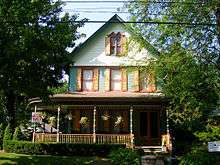

Tottenville has a strong Victorian architecture heritage, akin to neighborhoods on Staten Island's North Shore. This is unique to this South Shore neighborhood, compared to the other South Shore areas, all of which were developed much later. Seven buildings in Tottenville have been honored with the Preservation League of Staten Island Award: 88 Bentley Street, 24 Brighton Street, 213 Wood Avenue, 115 Bentley Street, 7647 Amboy Road, 7639 Amboy Road, and the Tottenville Branch of the New York Public Library. 88 Bentley Street has been photographed as an example of Staten Island's carefully restored Victorian homes in "New York City - The Five Boroughs: A Photographic Tour" by Carol M. Highsmith and Ted Landphair, published 1997. In addition, the Old Church of St. Joachim and St. Anne was restored after a fire into a home for children.
Demographics
Tottenville's population is largely White (nearly 87 percent as of 2010), the neighborhood is mostly made of upper-middle-class families, and has the highest proportion of Roman Catholics than any other neighborhood on the island (94% Roman Catholic). In the mid 2000s the community witnessed the arrival of Mexican immigrants for the first time There is also a growing number of Coptic Orthodox Christians from Egypt; as of 2012, the Virgin St. Mary and St. George Coptic Orthodox Church in Tottenville[1] is one of two Coptic Parishes on Staten Island.[2]
The 2000 Census showed that ZIP Code 10307, essentially coterminous with Tottenville (a fortuitous circumstance as most neighborhoods of New York City do not have officially recognized boundaries) had a population of 9,207, whose median age was 35.4, and the zip code's per-capita income was found to be $27,688. The average household size was 2.99 persons
According to the 2010 census, the demographics were 87% White, 1% Black, 2% Asian, and 1% Multiracial. Hispanics/Latinos of any race made up 9% of the population. Tottenville's White Population is 60% Italian as of 2012,[3] which plays a big part in the culture of Tottenville. There are also a lot of people of Irish descent.
The median income of the area was around $86,000 in 2009. [4]. The numbers are a little bit higher because Tottenville Beach is slightly wealthier. Roughly 4% of the population lives below the poverty line.
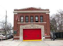
The 123rd Precinct of the New York City Police Department has its headquarters there, as does the Engine Co. 151/Ladder Co. 76 of the New York City Fire Department, and the neighborhood also has a branch of the New York Public Library.
Climate
| Climate data for Perth Amboy, New Jersey (across river/kill from Tottenville) | |||||||||||||
|---|---|---|---|---|---|---|---|---|---|---|---|---|---|
| Month | Jan | Feb | Mar | Apr | May | Jun | Jul | Aug | Sep | Oct | Nov | Dec | Year |
| Average high °F (°C) | 39 (4) |
43 (6) |
52 (11) |
64 (18) |
74 (23) |
83 (28) |
87 (31) |
85 (29) |
78 (26) |
66 (19) |
55 (13) |
43 (6) |
64 (18) |
| Average low °F (°C) | 23 (−5) |
25 (−4) |
32 (0) |
41 (5) |
50 (10) |
60 (16) |
65 (18) |
64 (18) |
56 (13) |
45 (7) |
36 (2) |
28 (−2) |
44 (7) |
| Average precipitation inches (mm) | 3.63 (92.2) |
3.06 (77.7) |
4.13 (104.9) |
4.01 (101.9) |
4.22 (107.2) |
4.21 (106.9) |
5.50 (139.7) |
3.73 (94.7) |
4.57 (116.1) |
4.21 (106.9) |
3.85 (97.8) |
4.00 (101.6) |
49.12 (1,247.6) |
| Source: [5] | |||||||||||||
Transportation
The Tottenville station has been the southern terminus of the Staten Island Railway since the railway was extended to the neighborhood on June 2, 1860. Today, the neighborhood of Tottenville contains the two southernmost stations along the line, including Tottenville (which is the southernmost railway station in New York state), and Arthur Kill station.[6] Before Arthur Kill opened on January 21, 2017, there were two other stations which were Atlantic (named after the defunct Atlantic Terra Cotta Co. factory nearby) and Nassau (referring to Nassau Smelting and Refining, the original name of the factory later taken over by Lucent Technologies), which closed on the same day that Arthur Kill was opened, as Arthur Kill replaced both of them. Atlantic and Nassau stations are now closed and demolished.[7]
Tottenville is served by the S59 and S78 local buses. Express bus service to and from Manhattan is provided by the SIM2, SIM25 and SIM26.[8]
Notable residents
Patti Hansen, a model and actress who is married to Rolling Stones guitarist Keith Richards, was born and raised in Tottenville.
Education
Schools
Tottenville High School, a public school, was originally located in the neighborhood, but a new campus was opened approximately three miles to the north, in the neighborhood of Huguenot, in 1971 (Totten Intermediate or I.S. 34, an intermediate school, now occupies the original high school building). One of the area's oldest buildings is the old building of P.S.1 (the Tottenville School), dating from 1878, and is unique for its traditional sloped roof. Today it is still in operation, now served by a second, newer building as well, built in 1929. In 2000, a new elementary school, P.S.6 (the Corporal Allan F. Kivlehan School), was opened to serve eastern Tottenville's growing population, as well as other neighboring areas. Tottenville's local Catholic school is Our Lady Help of Christians School, which is run under Our Lady Help of Christians Parish. The school dates back to 1904.
The southern part of Tottenville below Hylan Boulevard is also known as Tottenville Beach.
Public libraries
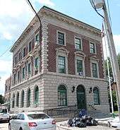
New York Public Library operates the Tottenville Branch at 7430 Amboy Road.[9] The building, one of the Carnegie libraries, was designed by Carrere & Hastings and completed in 1904.
Tottenville Beach
Tottenville Beach was largely undeveloped until the 1990s. It is exclusively residential, and is bordered on the south and west by Conference House Park. While the beach that the area is named for is not popular with swimmers or sunbathers, it is a popular place for fishing. Several hotels dotted the shoreline in the area during the first half of the 20th century, including the Shore House Hotel. The Coral Bay Cafe restaurant operated there but was destroyed by Hurricane Sandy.
References
- ↑ "H.H. Pope Shenouda III consecrates St. Mary & St George, Staten Island, New York". Hope Pictures.
- ↑ "Coptic churches in 10307". Coptic Orthodox Church Network. Retrieved 2012-03-18.
- ↑ "Selected Social Characteristics in the United States 2008-2012". American Community Survey U.S. Census. Retrieved 2014-01-09.
- ↑ (http://www.city-data.com/neighborhood/Tottenville-Staten-Island-NY.html)
- ↑ "Average weather for Perth Amboy, New Jersey". Weather.com. Retrieved December 20, 2008.
- ↑ "Subway Map" (PDF). Metropolitan Transportation Authority. January 18, 2018. Retrieved January 18, 2018.
- ↑ "New Arthur Kill Station". mta.info. Metropolitan Transportation Authority. January 20, 2017. Retrieved January 20, 2017.
- ↑ "Staten Island Bus Map" (PDF). Metropolitan Transportation Authority. August 2018. Retrieved August 18, 2018.
- ↑ "Tottenville Branch." New York Public Library. Retrieved on December 22, 2008.
Coordinates: 40°30′23.1″N 74°14′34.9″W / 40.506417°N 74.243028°W