Tiszafüred District
| Tiszafüred District Tiszafüredi járás | ||
|---|---|---|
| Districts of Hungary | ||
| ||
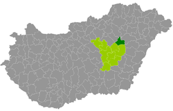 Tiszafüred District within Hungary and Jász-Nagykun-Szolnok County. | ||
| Country |
| |
| County | Jász-Nagykun-Szolnok | |
| District seat | Tiszafüred | |
| Area | ||
| • Total | 417.05 km2 (161.02 sq mi) | |
| Area rank | 9th in Jász-Nagykun-Szolnok | |
| Population (2011 census) | ||
| • Total | 19,559 | |
| • Rank | 9th in Jász-Nagykun-Szolnok | |
| • Density | 47/km2 (120/sq mi) | |

Tiszafüred (Hungarian: Tiszafüredi járás) is a district in north-eastern part of Jász-Nagykun-Szolnok County. Tiszafüred is also the name of the town where the district seat is found. The district is located in the Northern Great Plain Statistical Region.
Geography
Tiszafüred District borders with Mezőkövesd District (Borsod-Abaúj-Zemplén County) to the north, Balmazújváros District (Hajdú-Bihar County) to the east, Karcag District to the south, Kunhegyes District and Füzesabony District (Heves County) to the west. The number of the inhabited places in Tiszafüred District is 7.
Municipalities
The district has 1 town and 6 villages. (ordered by population, as of 1 January 2012)[1]
- Nagyiván (1,179)
- Tiszaderzs (1,046)
- Tiszafüred (10,694) – district seat
- Tiszaigar (813)
- Tiszaörs (1,225)
- Tiszaszentimre (2,086)
- Tiszaszőlős (1,945)
The bolded municipality is city.
Demographics
Religion in Tiszafüred District (2011 census)
In 2011, it had a population of 19,559 and the population density was 47/km².
| Year | County population[2] | Change |
|---|---|---|
| 2011 | 19,559 | n/a |
Ethnicity
Besides the Hungarian majority, the main minorities are the Roma (approx. 1,000) and German (200).
Total population (2011 census): 19,559
Ethnic groups (2011 census):[3] Identified themselves: 17,758 persons:
- Hungarians: 16,572 (93.32%)
- Gypsies: 708 (3.99%)
- Germans: 228 (1.28%)
- Others and indefinable: 250 (1.41%)
Approx. 2,000 persons in Tiszafüred District did not declare their ethnic group at the 2011 census.
Religion
Religious adherence in the county according to 2011 census:[4]
- Catholic – 5,389 (Roman Catholic – 5,318; Greek Catholic – 71);
- Reformed – 4,211;
- Evangelical – 37;
- other religions – 248;
- Non-religious – 4,047;
- Atheism – 145;
- Undeclared – 5,482.
Gallery
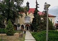 Tiszafüred, Town Hall
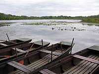 Tisza river in Tiszaörvény
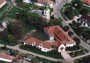 Aerial view of Tiszaderzs
_(6070._sz%C3%A1m%C3%BA_m%C5%B1eml%C3%A9k)_2.jpg) Our Lady of Hungary Church in Tiszafüred
Our Lady of Hungary Church in Tiszafüred
See also
References
- ↑ A KSH 2012. évi helységnévkönyve
- ↑ népesség.com, "Tiszafüredi járás népessége"
- ↑ 4.1.6.1 A népesség nemzetiség szerint, 2011, (in Hungarian)
- ↑ 4.1.7.1 A népesség vallás, felekezet szerint, 2011, (in Hungarian)
External links
| Town (1) |
| |
|---|---|---|
| Villages (6) | ||
Coordinates: 47°29′00″N 20°42′00″E / 47.4833°N 20.7000°E