Mezőtúr District
| Mezőtúr District Mezőtúri járás | ||
|---|---|---|
| Districts of Hungary | ||
| ||
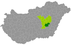 Mezőtúr District within Hungary and Jász-Nagykun-Szolnok County. | ||
| Country |
| |
| County | Jász-Nagykun-Szolnok | |
| District seat | Mezőtúr | |
| Area | ||
| • Total | 725.74 km2 (280.21 sq mi) | |
| Area rank | 3rd in Jász-Nagykun-Szolnok | |
| Population (2011 census) | ||
| • Total | 28,191 | |
| • Rank | 7th in Jász-Nagykun-Szolnok | |
| • Density | 39/km2 (100/sq mi) | |

Mezőtúr (Hungarian: Mezőtúri járás) is a district in south-eastern part of Jász-Nagykun-Szolnok County. Mezőtúr is also the name of the town where the district seat is found. The district is located in the Northern Great Plain Statistical Region. This district is a part of Nagykunság historical and geographical region.
Geography
Mezőtúr District borders with Törökszentmiklós District and Karcag District to the north, Gyomaendrőd District (Békés County) to the east, Szarvas District (Békés County) and Kunszentmárton District to the south, Szolnok District to the west. The number of the inhabited places in Mezőtúr District is 5.
Municipalities
The district has 2 towns and 3 villages. (ordered by population, as of 1 January 2012)[1]
- Kétpó (682)
- Mesterszállás (691)
- Mezőhék (317)
- Mezőtúr (17,337) – district seat
- Túrkeve (8,741)
The bolded municipalities are cities.
Demographics
Religion in Mezőtúr District (2011 census)
In 2011, it had a population of 28,191 and the population density was 39/km².
| Year | County population[2] | Change |
|---|---|---|
| 2011 | 28,191 | n/a |
Ethnicity
Besides the Hungarian majority, the main minority is the Roma (approx. 1,000).
Total population (2011 census): 28,191
Ethnic groups (2011 census):[3] Identified themselves: 24,515 persons:
- Hungarians: 23,576 (96.17%)
- Gypsies: 618 (2.52%)
- Others and indefinable: 321 (1.31%)
Approx. 3,500 persons in Mezőtúr District did not declare their ethnic group at the 2011 census.
Religion
Religious adherence in the county according to 2011 census:[4]
- Reformed – 5,688;
- Catholic – 2,609 (Roman Catholic – 2,575; Greek Catholic – 34);
- Evangelical – 103;
- other religions – 185;
- Non-religious – 12,292;
- Atheism – 316;
- Undeclared – 6,998.
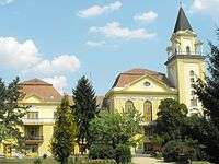
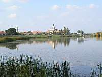
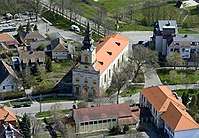
Gallery

See also
References
- ↑ A KSH 2012. évi helységnévkönyve
- ↑ népesség.com, "Mezőtúri járás népessége"
- ↑ 4.1.6.1 A népesség nemzetiség szerint, 2011, (in Hungarian)
- ↑ 4.1.7.1 A népesség vallás, felekezet szerint, 2011, (in Hungarian)
External links
| Towns (2) | ||
|---|---|---|
| Villages (3) | ||
Coordinates: 47°02′00″N 20°35′00″E / 47.0333°N 20.5833°E