Nagyiván
| Nagyiván | ||
|---|---|---|
| Village | ||
| ||
 Nagyiván | ||
| Coordinates: 47°29′14″N 20°55′39″E / 47.48722°N 20.92750°ECoordinates: 47°29′14″N 20°55′39″E / 47.48722°N 20.92750°E | ||
| Country |
| |
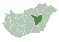
| County | Jász-Nagykun-Szolnok | |
| District | Tiszafüred | |
| Area | ||
| • Total | 43.16 km2 (16.66 sq mi) | |
| Population (2015) | ||
| • Total | 1,175[1] | |
| • Density | 27.2/km2 (70/sq mi) | |
| Time zone | UTC+1 (CET) | |
| • Summer (DST) | UTC+2 (CEST) | |
| Postal code | 5363 | |
| Area code(s) | (+36) 59 | |
Nagyiván is a village in Jász-Nagykun-Szolnok county, in the Northern Great Plain region of central Hungary.
Geography
It covers an area of 43.16 km2 (17 sq mi) and has a population of 1175 people (2015).[1] It is one of the driest area in Hungary. The annual precipitation is about 520 mm. The village lies at the edge of the Hortobágy National Park (the first and biggest Hungarian national park, part of the world heritage). The inhabitants mainly work in the agricultural sector.
References
- 1 2 Gazetteer of Hungary, 1st January 2015. Hungarian Central Statistical Office. 03/09/2015
External links
- Official site in Hungarian
| Town (1) |
| |
|---|---|---|
| Villages (6) | ||
| City with county rights |
|   |
|---|---|---|
| Towns | ||
| Large villages | ||
| Villages |
| |
| Other topics |
| |
This article is issued from
Wikipedia.
The text is licensed under Creative Commons - Attribution - Sharealike.
Additional terms may apply for the media files.