Jászberény District
| Jászberény District Jászberényi járás | ||
|---|---|---|
| Districts of Hungary | ||
| ||
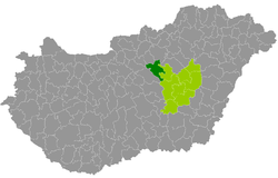 Jászberény District within Hungary and Jász-Nagykun-Szolnok County. | ||
| Country |
| |
| County | Jász-Nagykun-Szolnok | |
| District seat | Jászberény | |
| Area | ||
| • Total | 617.01 km2 (238.23 sq mi) | |
| Area rank | 4th in Jász-Nagykun-Szolnok | |
| Population (2011 census) | ||
| • Total | 51,274 | |
| • Rank | 2nd in Jász-Nagykun-Szolnok | |
| • Density | 83/km2 (210/sq mi) | |
Jászberény (Hungarian: Jászberényi járás) is a district in north-western part of Jász-Nagykun-Szolnok County. Jászberény is also the name of the town where the district seat is found. The district is located in the Northern Great Plain Statistical Region. This district is a part of Jászság historical, ethnographical and geographical region.
Geography
Jászberény District borders with Hatvan District and Gyöngyös District (Heves County) to the north, Jászapáti District to the east, Szolnok District to the south, Nagykáta District and Aszód District (Pest County) to the southwest. The number of the inhabited places in Jászberény District is 9.
Municipalities
The district has 3 towns and 6 villages. (ordered by population, as of 1 January 2012)[1]
- Jászágó (687)
- Jászárokszállás (7,806)
- Jászberény (26,924) – district seat
- Jászboldogháza (1,585)
- Jászfelsőszentgyörgy (1,974)
- Jászfényszaru (5,621)
- Jászjákóhalma (3,049)
- Jásztelek (1,627)
- Pusztamonostor (1,579)
The bolded municipalities are cities.
Demographics
Religion in Jászberény District (2011 census)
In 2011, it had a population of 51,274 and the population density was 83/km².
| Year | County population[2] | Change |
|---|---|---|
| 2011 | 51,274 | n/a |
Ethnicity
Besides the Hungarian majority, the main minorities are the Roma (approx. 2,000), German (150) and Romanian (100).
Total population (2011 census): 51,274
Ethnic groups (2011 census):[3] Identified themselves: 47,260 persons:
- Hungarians: 44,473 (94.10%)
- Gypsies: 2,152 (4.55%)
- Others and indefinable: 635 (1.34%)
Approx. 4,000 persons in Jászberény District did not declare their ethnic group at the 2011 census.
Religion
Religious adherence in the county according to 2011 census:[4]
- Catholic – 29,156 (Roman Catholic – 29,029; Greek Catholic – 122);
- Reformed – 1,557;
- Evangelical – 70;
- other religions – 578;
- Non-religious – 6,109;
- Atheism – 453;
- Undeclared – 13,351.
Gallery
 Jászberény, the Capital of Jászság
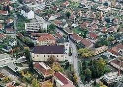 Aerial view of Jászárokszállás
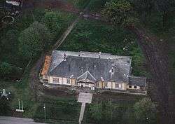 Balázsovich Mansion in Pusztamonostor
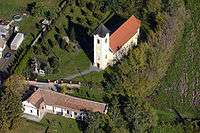 St. George Church in Jászfelsőszentgyörgy
 Lehel's horn
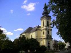 Great Church of Jászberény
See also
References
- ↑ A KSH 2012. évi helységnévkönyve
- ↑ népesség.com, "Jászberényi járás népessége"
- ↑ 4.1.6.1 A népesség nemzetiség szerint, 2011, (in Hungarian)
- ↑ 4.1.7.1 A népesség vallás, felekezet szerint, 2011, (in Hungarian)
External links
| Towns (3) |
| |
|---|---|---|
| Villages (6) | ||
Coordinates: 47°28′00″N 20°03′00″E / 47.4667°N 20.0500°E