Törökszentmiklós District
| Törökszentmiklós District Törökszentmiklósi járás | ||
|---|---|---|
| Districts of Hungary | ||
| ||
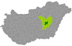 Törökszentmiklós District within Hungary and Jász-Nagykun-Szolnok County. | ||
| Country |
| |
| County | Jász-Nagykun-Szolnok | |
| District seat | Törökszentmiklós | |
| Area | ||
| • Total | 464.54 km2 (179.36 sq mi) | |
| Area rank | 8th in Jász-Nagykun-Szolnok | |
| Population (2011 census) | ||
| • Total | 36,739 | |
| • Rank | 4th in Jász-Nagykun-Szolnok | |
| • Density | 79/km2 (200/sq mi) | |

Törökszentmiklós (Hungarian: Törökszentmiklósi járás) is a district in central part of Jász-Nagykun-Szolnok County. Törökszentmiklós is also the name of the town where the district seat is found. The district is located in the Northern Great Plain Statistical Region. This district is a part of Nagykunság historical and geographical region.
Geography
Törökszentmiklós District borders with Kunhegyes District to the north, Karcag District to the east, Mezőtúr District to the southeast, Szolnok District to the west and north. The number of the inhabited places in Törökszentmiklós District is 7.
Municipalities
The district has 2 towns and 5 villages. (ordered by population, as of 1 January 2012)[1]
- Fegyvernek (6,415)
- Kengyel (3,857)
- Kuncsorba (585)
- Örményes (1,049)
- Tiszapüspöki (2,005)
- Tiszatenyő (1,627)
- Törökszentmiklós (21,043) – district seat
The bolded municipalities are cities.
Demographics
Religion in Törökszentmiklós District (2011 census)
In 2011, it had a population of 36,739 and the population density was 79/km².
| Year | County population[2] | Change |
|---|---|---|
| 2011 | 36,739 | n/a |
Ethnicity
Besides the Hungarian majority, the main minorities are the Roma (approx. 1,500) and German (100).
Total population (2011 census): 36,739
Ethnic groups (2011 census):[3] Identified themselves: 33,338 persons:
- Hungarians: 31,779 (95.32%)
- Gypsies: 1,208 (3.62%)
- Others and indefinable: 351 (1.05%)
Approx. 3,500 persons in Törökszentmiklós District did not declare their ethnic group at the 2011 census.
Religion
Religious adherence in the county according to 2011 census:[4]
- Catholic – 10,728 (Roman Catholic – 10,655; Greek Catholic – 73);
- Reformed – 3,780;
- Evangelical – 49;
- other religions – 301;
- Non-religious – 12,179;
- Atheism – 310;
- Undeclared – 9,392.
Gallery
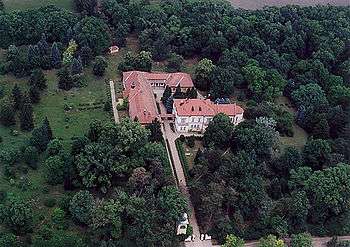 Almásy Mansion in Törökszentmiklós
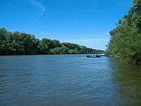 Tisza river near Tiszapüspöki
 Puszatorony from above (Fegyvernek)
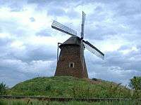 Windmill Hill near Kengyel
See also
References
- ↑ A KSH 2012. évi helységnévkönyve
- ↑ népesség.com, "Törökszentmiklósi járás népessége"
- ↑ 4.1.6.1 A népesség nemzetiség szerint, 2011, (in Hungarian)
- ↑ 4.1.7.1 A népesség vallás, felekezet szerint, 2011, (in Hungarian)
External links
| Towns (2) |
| |
|---|---|---|
| Villages (5) |
| |