Tinajo (municipality)
| Tinajo | |||
|---|---|---|---|
| Municipality | |||
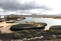 Former desalination lagoon in Tinajo | |||
| |||
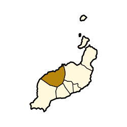 Municipal location in Lanzarote | |||
 Tinajo Location in the province of Las Palmas  Tinajo Tinajo (Canary Islands)  Tinajo Tinajo (Spain, Canary Islands) | |||
| Coordinates: 29°4′N 13°40′W / 29.067°N 13.667°WCoordinates: 29°4′N 13°40′W / 29.067°N 13.667°W | |||
| Country |
| ||
| Autonomous community |
| ||
| Province | Las Piñas | ||
| Island | Lanzarote | ||
| Government | |||
| • Mayor | Juan Pedro Hernández Rodríguez (CC) | ||
| Area[1] | |||
| • Total | 135.28 km2 (52.23 sq mi) | ||
| Population (2013)[2] | |||
| • Total | 5,783 | ||
| • Density | 43/km2 (110/sq mi) | ||
| Time zone | UTC±0 (WET) | ||
| • Summer (DST) | UTC+1 (WEST) | ||
| Postal code | 35530 | ||
| Website | Official website | ||
.gif)
Tinajo is a municipality in the western part of the island of Lanzarote in the Province of Las Palmas in the Canary Islands, Spain. The population is 5,783 (2013),[2] and the area is 135.28 km².[1] It is located near the north coast, northwest of the island capital Arrecife. The main town in the municipality is Tinajo.
Historical population
| Historical population | |||||||||||||||||||
|---|---|---|---|---|---|---|---|---|---|---|---|---|---|---|---|---|---|---|---|
|
| ||||||||||||||||||
Communities
Sites of interest
The Timanfaya National Park (created in 1974) covers the southwestern part of the municipality and is where most of its mountains are located. The park features volcanic mountains and rugged lands. The rest of the park is in Yaiza municipality.
In Mancha Blanca is the chapel of the Our Lady of Dolours (Virgen de los Dolores), the patron saint of the island of Lanzarote.
See also
References
- 1 2 Instituto Canario de Estadística, area
- 1 2 Instituto Canario de Estadística Archived 2014-04-19 at the Wayback Machine., population
External links
| Wikimedia Commons has media related to Tinajo. |
Places adjacent to Tinajo (municipality) | ||||||||||
|---|---|---|---|---|---|---|---|---|---|---|
| ||||||||||
This article is issued from
Wikipedia.
The text is licensed under Creative Commons - Attribution - Sharealike.
Additional terms may apply for the media files.