Tigray Region
| Tigray ትግራይ | ||
|---|---|---|
| State | ||
| ||
| Nickname(s): The birth place of Ethiopian Civilization | ||
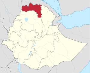 Map of Ethiopia showing Tigray | ||
| Country | Ethiopia | |
| Capital | Mekelle | |
| Government | ||
| • Vice President (Acting as President) | Dr. Debretsion Gebremichael (TPLF) | |
| Area | ||
| • Total | 53,638 km2 (20,710 sq mi) | |
| Area rank | 5th | |
| [1] | ||
| Population (2017) | ||
| • Total | 5,247,005[2] | |
| • Rank | 5th | |
| ISO 3166 code | ET-TI | |
Tigray Region (Amharic: ክልል ትግራይ, kilil Tigrāy; Official name: Amharic: ብሔራዊ ክልላዊ መንግሥቲ ትግራይ, Bəh̩erawi Kəllelawi Mängəśti Təgray, "Tigray National Regional State") is the northernmost of the nine regions (kililat) of Ethiopia. Tigray is the homeland of the Tigrayan, Irob and Kunama peoples. Tigray is also known as Region 1 according to the federal constitution. Its capital and largest city is Mekelle. Tigray is the 6th largest by area, the 5th most populous, and the 5th most densely populated of the 9 Regional States.
Tigray's official language is Tigrigna. Tigray is situated between 12°–15° N and 36° 30' – 40° 30' E and comprises 53,638 square kilometres (20,710 sq mi)[3] Tigray has ca. 5.3 million inhabitants. The greatest part of the population (ca. 80%) are agriculturalists, contributing 46% to the regional gross domestic product (2002/03). The highlands (11.5% dəgʷəa, 40.5% wäyna däga) have the highest population density, specially in eastern and central Tigray. The much less densely populated lowlands of Tigray (qʷälla) comprise 48% of Tigray.
Tigray is bordered by Eritrea to the north, Sudan to the west, the Afar Region to the east, and the Amhara Region to the south and southwest.[4] Besides Mekelle, major cities include Adigrat, Aksum, Shire, Humera, Adwa, Alamata, Wukro, Maychew, Sheraro, Abiy Adi, Korem, Qwiha, Hawzen, Mekoni and Zalambessa. There is also the historically significant town of Yeha.
The government of Tigray is composed of the executive branch, led by the President; the legislative branch, which comprises the State Council; and the judicial branch, which is led by the state Supreme Court.
History
3rd millennium to 5th century BC
Given the presence of a large temple complex and fertile surroundings, the capital of Dʿmt may have been present day Yeha, in Tigray, Ethiopia.[5]
The kingdom developed irrigation schemes, used plows, grew millet, and made iron tools and weapons.
Some modern historians including Stuart Munro-Hay, Rodolfo Fattovich, Ayele Bekerie, Cain Felder, and Ephraim Isaac consider this civilization to be indigenous, although Sabaean-influenced due to the latter's dominance of the Red Sea, while others like Joseph Michels, Henri de Contenson, Tekle-Tsadik Mekouria, and Stanley Burstein have viewed Dʿmt as the result of a mixture of Sabaeans and indigenous peoples.[6][7] The most recent research, however, shows that Ge'ez, the ancient Semitic language spoken in Eritrea and northern Ethiopia in ancient times, is not derived from Sabaean.[8] There is evidence of a Semitic-speaking presence in Eritrea and northern Ethiopia at least as early as 2000 BC.[7][9] It is now believed that Sabaean influence was minor, limited to a few localities, and disappeared after a few decades or a century, perhaps representing a trading or military colony in some sort of symbiosis or military alliance with the civilization of Dʿmt or some other proto-Aksumite state.[10][11]
After the fall of Dʿmt in the 5th century BC, the plateau came to be dominated by smaller unknown successor kingdoms. This lasted until the rise of one of these polities during the first century BC, the Aksumite Kingdom. The ancestor of medieval and modern Eritrea and Ethiopia, Aksum was able to reunite the area.[12]
1st to 10th century AD
The Kingdom of Aksum was a trading empire centered in Eritrea and northern Ethiopia.[13] It existed from approximately 100–940 AD, growing from the proto-Aksumite Iron Age period c. 4th century BC to achieve prominence by the 1st century AD.
According to the Book of Aksum, Aksum's first capital, Mazaber, was built by Itiyopis, son of Cush.[14] The capital was later moved to Aksum in northern Ethiopia. The Kingdom used the name "Ethiopia" as early as the 4th century.[15][16]
The Empire of Aksum at its height at times extended across most of present-day Eritrea, Ethiopia, Djibouti, Sudan, Egypt, Yemen and Saudi Arabia. The capital city of the empire was Aksum, now in northern Ethiopia. Today a smaller community, the city of Aksum was once a bustling metropolis, cultural and economic center. Two hills and two streams lie on the east and west expanses of the city; perhaps providing the initial impetus for settling this area. Along the hills and plain outside the city, the Aksumites had cemeteries with elaborate grave stones called stelae, or obelisks. Other important cities included Yeha, Hawulti-Melazo, Matara, Adulis, and Qohaito, the last three of which are now in Eritrea. By the reign of Endubis in the late 3rd century, it had begun minting its own currency and was named by Mani as one of the four great powers of his time along with Persia, Rome, and China. It converted to Christianity in 325 or 328 under King Ezana and was the first state ever to use the image of the cross on its coins.[17][18]
11th to 19th century AD
In the 14th century the Tigrinya-speaking lands (Tigray-Mereb Melash) were divided into two provinces, separated by the Mereb River by the newly enthroned Amhara Emperors. The governor of the northern province received the title Baher Neagsh (Ruler of the sea), whereas the governor of the southern province was given the title of Tigray Mekonen (Lord of Tigray). The Portuguese Jesuit, Emanuele Baradas' work titled "Do reino de Tigr" and written in 1633-34 states that the "reino de Tigr" extended from Hamasien to Temben, from the borders of Dankel to the Adwa mountain. He also stated that Tigray-Mereb Melash was divided into twenty-four smaller political units (principalities), twelve of which were located south of the Mereb and governed by the Tigray Mekonen based in Enderta.[19] The other twelve were located north of the Mereb under the authority of the Baher Negash, based in the district of Serae.[19]
The Book of Aksum, written and compiled probably before the 15th century, shows a traditional schematic map of Tigray with the city of Aksum at its center surrounded by the 13 principal provinces: "Tembien, Shire, Serae, Hamasien, Bur, Sam’a, Agame, Amba Senayt, Garalta, Enderta, Sahart and Abergele."[20]
During the Middle Ages, the position of Tigray Mekonnen ("Governor of Tigray") was established to rule over the area. Other districts included Akkele Guzay (now part of Eritrea), and the kingdom of the Bahr negus, who ruled much of what is now Eritrea and Shire district and town in Western Tigray. At the time when Tigray Meknonnen existed simultaneously with that of Bahr negus, their frontier seems to have been the Mareb River, which is currently constitutes the border between the Ethiopian province of Tigray and Eritrea.
After the loss of power of the Bahr negus in the aftermath of Bahr negus Yeshaq's rebellions, the title of Tigray mekonnen gained power in relation to the Bahr negus and at times included ruling over parts of what is now Eritrea, especially in the 19th century.[21] By the unsettled Zemene Mesafint period ("Era of the Princes"), both titles had sunken to little more than empty titles, and the Lord who in his turn dominated the region, used (and received from Emperor) the title of either Ras or Dejazmach, beginning with Ras Mikael Sehul. Rulers of Tigray such as Ras Wolde Selassie alternated with others, chiefly those of Begemder or Yejju, as warlords to rule in fact the Ethiopian monarchy during the Zemene Mesafint.
In the mid-19th century, the lords of Tembien and Enderta managed to create an overlordship of Tigray to their dynasty. One of its members, Dejazmach Kassai Mercha, ascended the imperial throne in 1872 under the name Yohannes IV. Following his death in the Battle of Metemma, the Ethiopian throne came under the control of the king of Shewa, and the center of power shifted south and away from Tigray.
20th century
In 1943, open resistance broke out all over southern and eastern Tigray under the slogan, "there is no government; let's organize and govern ourselves." Throughout Enderta awraja including, Mekelle, Didibadergiajen, Hintalo, Saharti, Samre and Wajirat, Raya awraja, Kilete-Awlaelo awraja and Tembien awraja, local assemblies, called gerreb, were immediately formed. The gerreb sent representatives to a central congress, called the shengo, which elected leaders and established a military command system. Although the Woyane rebellion of 1943 had shortcomings as a prototype revolution, historians, however, agree that the Woyane rebellion had involved a fairly high level of spontaneity and peasant initiative. It demonstrated considerable popular participation and reflected widely shared grievances. The uprising was unequivocally and specifically directed against the central Shoan Amhara regime of Haile Selassie I, rather than the Tigrayan imperial elite.
Ethiopian Civil War
After the February 1974 popular revolution, the first signal of any mass uprising was the actions of the soldiers of the 4th Brigade of the 4th Army Division in Nagelle in southern Ethiopia. The Coordinating Committee of the Armed Forces, Police, and Territorial Army, or the Derg (Ge'ez "Committee"), was officially announced 28 June 1974 by a group of military officers. The committee elected Major Mengistu Haile Mariam as its chairman and Major Atnafu Abate as its vice-chairman. In July the Derg obtained key concessions from the emperor, Haile Selassie, which included the power to arrest not only military officers but government officials at every level. Soon both former Prime Ministers Tsehafi Taezaz Aklilu Habte-Wold and Endelkachew Makonnen, along with most of their cabinets, most regional governors, many senior military officers and officials of the Imperial court were imprisoned. In August, after a proposed constitution creating a constitutional monarchy was presented to the emperor, the Derg began a program of dismantling the imperial government in order to forestall further developments in that direction. The Derg deposed and imprisoned the emperor on September 12, 1974. In addition, the Derg in 1975 nationalized most industries and private and somewhat secure urban real-estate holdings.
But, mismanagement, corruption, and general hostility to the Derg's violent rule, coupled with the draining effects of constant warfare with the separatist guerrilla movements in Tigray, led to a drastic fall in general productivity of food and cash crops. In October 1978, the Derg announced the National Revolutionary Development Campaign to mobilize human and material resources to transform the economy, which led to a Ten-Year Plan (1984/85-1993/94) to expand agricultural and industrial output, forecasting a 6.5% growth in GDP and a 3.6% rise in per capita income. Instead, per capita income declined 0.8% over this period. Famine scholar Alex de Waal observes that while the famine that struck the country in the mid-1980s is usually ascribed to drought, "closer investigation shows that widespread drought occurred only some months after the famine was already under way." Hundreds of thousands fled economic misery, conscription, and political repression, and went to live in neighboring countries and all over the Western world, creating an Ethiopian diaspora for the first time.
Towards the end of January 1991, a coalition of rebel forces, the Ethiopian People's Revolutionary Democratic Front (EPRDF) captured Gondar, the ancient capital city, Bahar Dar, and Dessie.
Post-war
Following the conclusion of the Ethiopian Civil War, although the area which became the Tigray Region was thought by inhabitants in the rest of Ethiopia to be the beneficiaries of enormous funds from an Ethiopian People's Revolutionary Democratic Front (EPRDF) government dominated by fellow Tigrayans, in reality the beneficiaries are mostly the party members of Tigray people liberation front /TPLF/. John Young, who visited the area several times in the early 1990s, attributes this delay in part to "Budgetary restraints, structural readjustments, and lack of awareness in Addis Ababa of conditions in the province", but notes "an equally significant obstacle was posed by an entrenched, and largely Amhara dominated central bureaucracy which used its power to block even authorised funds from reaching all regions." At the same time, a growing urban middle class of traders, businessmen and government officials emerged which was both suspicious and distant from the victorious EPRDF. The ruling party attempted to address these challenges in forums with its middle class critics, as well as the establishment of a number of charitable non-governmental organizations controlled by the EPRDF, which include Endowment Fund for the Rehabilitation of Tigray, Relief Society of Tigray, and Tigray Development Association. In 1998, war erupted between Eritrea and Ethiopia over a portion of territory that had been administered at part of Tigray, which included the town of Badme. Following a 2002 United Nations decision, much of this land was awarded to Eritrea, so far however, Ethiopia has refused to implement the final and binding ruling and as a result, relation with Eritrea is very tense.
From 1991 to 2001 the president of Tigray was Gebru Asrat and from 2001 to 2010 the president was Tsegay Berhe
In 1998, war erupted between Eritrea and Ethiopia over a portion of territory that had been administered at part of Tigray, which included the town of Badme.
Major cities
| Rank | District | Pop. | |||||||
|---|---|---|---|---|---|---|---|---|---|
 Adigrat |
1 | Mekelle | Enderta | 219,818 | .jpg) Axum | ||||
| 2 | Adigrat | Ganta Afeshum | 76,400 | ||||||
| 3 | Axum | Laelay Maychew | 56,500 | ||||||
| 4 | Shire Inda Selassie | Tahtay Koraro | 47,284 | ||||||
| 5 | Humera | Kafta Humera | 41,653 | ||||||
| 6 | Adwa | Adwa | 40,500 | ||||||
| 7 | Alamata | Alamata | 33,214 | ||||||
| 8 | Wukro | Kelete Awelallo | 30,210 | ||||||
| 9 | Maychew | Endamehony | 23,419 | ||||||
| 10 | Sheraro | Tahtay Adiyabo | 17,045 | ||||||
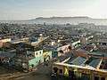
Mekelle (home of Mekelle University, Mekelle Institute of Technology, Microlink College, Nile College, and Mekelle College of Teacher Education) is the capital of Tigray, near the geographic center of the state.
Other Tigray cities functioning as centers of Ethiopian metropolitan areas include:
- Adigrat (home of Adigrat University, Debre Damo monastery and Addis Pharmaceuticals)
- Adwa (home of Adwa Pan African University,)
- Axum (home of Aksum University,)
- Maychew (home of Raya University)
Demographics

Based on the 2007 Census conducted by the Central Statistical Agency of Ethiopia (CSA), the Tigray Region has a population of 4,316,988, of whom 2,126,465 are men and 2,190,523 women; urban inhabitants number 844,040 or 19.55% of the population. With an estimated area of 41,409.95 square kilometers, this region has an estimated density of 100 people per square kilometer. For the entire region 992,635 households were counted, which results in an average for the Region of 4.4 persons to a household, with urban households having on average 3.4 and rural households 4.6 people.[23] The population was projected to be 5,247,005 in 2017.[2]
In the previous census, conducted in 1994, the Region's population was 3,136,267, of whom 1,542,165 were men and 1,594,102 women; urban inhabitants numbered 621,210 or 14% of the population.
According to the CSA, as of 2004, 53.99% of the total population had access to safe drinking water, of whom 42.68% were rural inhabitants and 97.28% were urban.[24] Values for other reported common indicators of the standard of living for Tigray as of 2005 include the following: 31.6% of the inhabitants fall into the lowest wealth quintile; adult literacy for men is 67.5% and for women 33.7%; and the Regional infant mortality rate is 67 infant deaths per 1,000 live births, which less than the nationwide average of 77; at least half of these deaths occurred in the infants’ first month of life.[25]
Ethnicity
At 96.55% of the local population, the region is predominantly inhabited by the Tigrinya speaking Tigrayan people. The Tigrinya language is classified as belonging to the Semitic branch of the Afro-Asiatic family of languages. Most other residents hail from other Afro-Asiatic speaking communities, including the Amhara, Irob, Afar, Agaw and Oromo. There are also a minority of Nilo-Saharan-speaking Kunama Nilotes.
| Ethnic group |
1994 Census | 2007 Census |
|---|---|---|
| Tigrayan | 94.98% | 96.55% |
| Amhara | 2.6% | 1.63% |
| Irob | 0.7% | 0.71% |
| Afar | - | 0.29% |
| Agaw | - | 0.19% |
| Oromo | - | 0.17% |
| Kunama | 0.05% | 0.07% |
Religion
| Religion | 1994 Census | 2007 Census[26] |
|---|---|---|
| Orthodox Christians | 95.5% | 95.6% |
| Muslim | 4.1% | 4.0% |
| Catholics | 0.4% | 0.4% |
Languages
The working language is Tigrinya, although most urban people are also able to speak Amharic, which is taught in schools.[27]
Economy
The CSA estimated in 2005 that farmers in Tigray had a total of 2,713,750 cattle (representing 7.0% of Ethiopia's total cattle), 72,640 sheep (0.42%), 208,970 goats (1.61%), 1,200 horses (less than 0.1%), 9,190 mules (6.24%), 386,600 asses (15.43%), 32,650 camels (7.15%), 3,180,240 poultry of all species (10.3%), and 20,480 beehives (0.47%).[28]
Terracing and dam construction
A particular aspect of the agricultural work in Tigray after the end of the 1991 civil war was minimizing the problems of drought. In the past, the Tigray was covered with forests and had a micro-climate that favored the rains. Subsequently, the forests were cut down, usually to impoverish the population during the wars. Consequently, the Tigray was a country achieved a fair amount of rainfall during the rainy season, from August to September, but quickly lost these waters flowing downstream. In the process it was also eroded the fertile soil of the fields, which led to the valley gave the characteristic color to Blue Nile. After a few weeks of rain, the country was again dried up.[29][30]
Terracing
The new government undertook two projects in Tigray. The first was the construction of terraces which, in agreement and with help of local communities, go up to the tops of the mountains at 2,500 meters. The goal was to prevent the rainfall flowing away immediately so that it could be conserved for the agricultural season. On the highest terraces there were planted trees, mainly eucalyptus which is the dominant tree in Ethiopia and is a native of Australia. These plants had to create a new microclimate.[31][29]

The terracing method was very simple, but required a good organization. Long stretches of the appropriate fields were terraced by the villagers using stone walls from stones that erosion had brought to light. The rains eroding the still non-terraced ground formed mudslides that were held by the topmost walls, which then permitted to construct new terrace field and another wall with uncovered stones, creating year after year new ground terraced farmland.
The size of the process of transformation of Tigray is truly extraordinary. After four or five years after the project commencement, almost all of Tigray, with an territorial area only slightly less than Italy, was terraced.[29][30]
Dams
The second project involved the construction of new reservoirs. The dam needed to create these basins is typically an embankment along tens or hundreds of meters, from one part of a valley, and the top 10 or 12 meters. A work like this took months of work, in which people wore the earth in baskets loaded on the head, even without using mules. Generally 2,000-3,000 people - men, women and children - were carrying the earth dam in simple baskets[29][30]
Landmarks
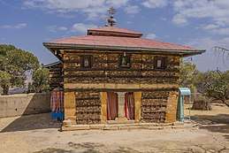
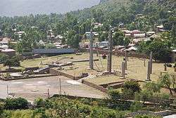
A distinctive feature of Tigray are its rock-hewn churches. Similar in design to those of Lalibela in the Amhara Region, these churches are found in four or five clusters – Gheralta, Teka-Tesfay, Atsbi and Tembien – with Wukro sometimes included. Some of the churches are considered earlier than those of Lalibela, perhaps dating from the eighth century. Mostly monolithic, with designs partly inspired by classical architecture, they are often located at the top of cliffs or steep hills, for security. For example, Tigray's ancient Debre Damo monastery is accessible only by climbing a rope 25 meters up a sheer cliff.
Looting has become a major issue in the Tigray Region, as archaeological sites have become sources for construction materials and ancient artifacts used for everyday purposes by local populations.[32]
The area is famous for a single rock sculptured 23 meter long obelisk in Axum as well as for other fallen obelisks. The Axum treasure site of ancient Tigrayan history is a major landmark. Yeha is another important local landmark that is little-known outside the region.
Transportation
Ground travel
A major north-south transportation corridor goes through Tigray. This is facilitated by the Highway 2 which goes from Adigrat to Addis Ababa and Highway 3 which goes from Shire to Addis Ababa.
Air travel
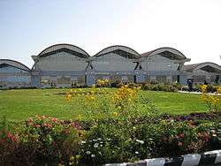
Tigray has 1 international airport and 4 commercial airports. The international airport is Alula Aba Nega Airport. The 4 commercial airports are Shire Airport, Humera Airport, Dansha Airport, and Axum Atse Yohannes 4th Airport.
Law and government
Executive branch
The executive branch is headed by the President of Tigray. The current president is Dr. Debretsion Gebremichael, a TPLF member, elected in 2018.[33] A Vice President of Tigray succeeds the president in the event of any removal from office, and performs any duties assigned by the president.[34] The current vice president is Dr. Addis Alem Balema.[35] The other elected constitutional offices in the executive branch are the Regional Health Bureau (Ato Hagos Godefy),[36] Educational Bureau (Ato Gebre'egziabher),[37] Auditor General (Ato Alemseged Kebedew),[38] and 12 other officials.[39]
Judicial branch
There are three levels of the Tigray state judiciary. The lowest level is the court of common pleas: each woreda maintains its own constitutionally mandated court of common pleas, which maintain jurisdiction over all justiciable matters.[40] The intermediate-level court system is the district court system. Four courts of appeals exist, each retaining jurisdiction over appeals from common pleas, municipal, and county courts in an administrative zone. A case heard in this system is decided by a three-judge panel, and each judge is elected.
The highest-ranking court, the Tigray Supreme Court, is Tigray's "court of last resort".[41] A seven-justice panel composes the court, which, by its own discretion, hears appeals from the courts of appeals, and retains original jurisdiction over limited matters. The chief judge is called the President of Tigray Supreme Court (W/ro Hirity Miheretab).
Legislative branch
The State Council, which is the highest administrative body of the state, is made up of 152 members.[39]
National politics
Tigray is represented by 38 representatives in the Federal Democratic Republic of Ethiopia House of Peoples' Representatives.
Administrative zones
Like other Regions in Ethiopia, Tigray is subdivided into administrative zones
Education
At the regional level, the Tigray Education Bureau governs primary and secondary educational institutions. At the municipal level, there are approximately 300 school districts region-wide.
Colleges and universities
- Adigrat University
- Axum University
- Ethio-lmage College
- Greenwich College
- Hasenge College
- Mars Engineering College
- Mekelle University
- Mekelle Institute of Technology
- New Millennium College
- Nile College
- Raya University
- Sehba Info Tech & Business College
- Signal College
- St. Mary's University College
Libraries
Tigray is home to Ethiopia's most extensive church libraries that are found in the eastern and central zones of the region. There are several ongoing digitization projects to preserve previous historical texts.
- Axum Heritage Foundation
- Romanat Qeddus Mika'el Church
- Gunda Gunde Monastery
- Agwaza Monastery
- Debre Damo Monastery
See also
References
- ↑ 2011 National Statistics Archived 2013-03-30 at the Wayback Machine.
- 1 2 Population Projection of Ethiopia for All Regions At Wereda Level from 2014 – 2017. Federal Democratic Republic of Ethiopia Central Statistical Agency. Retrieved 4 June 2018.
- ↑ .Investment Guide. Mekelle: Tigray Region Investment Office. 2007.
- ↑ Eritrea and Ethiopia (Map). 1:5,000,000. Central Intelligence Agency. 2009. Map #803395.
- ↑ Shaw, Thurstan (1995), The Archaeology of Africa: Food, Metals and Towns, Routledge, p. 612, ISBN 978-0-415-11585-8
- ↑ Stuart Munro-Hay, Aksum: An African Civilization of Late Antiquity. Edinburgh: University Press, 1991, p. 57.
- 1 2 Nadia Durrani, The Tihamah Coastal Plain of South-West Arabia in its Regional context c. 6000 BC - AD 600 (Society for Arabian Studies Monographs No. 4) . Oxford: Archaeopress, 2005, p. 121.
- ↑ Kitchen, Andrew, Christopher Ehret, et al. 2009. "Bayesian phylogenetic analysis of Semitic languages identifies an Early Bronze Age origin of Semitic in the Near East." Proceedings of the Royal Society B: Biological Sciences 276 no. 1665 (June 22)
- ↑ Herausgegeben von Uhlig, Siegbert. Encyclopaedia Aethiopica, "Ge'ez". Wiesbaden: Harrassowitz Verlag, 2005, pp. 732.
- ↑ Munro-Hay, Aksum, p. 57.
- ↑ Phillipson. "The First Millennium BC in the Highlands of Northern Ethiopia and South–Central Eritrea: A Reassessment of Cultural and Political Development". African Archaeological Review (2009) 26:257–274
- ↑ Pankhurst, Richard K.P. Addis Tribune, "Let's Look Across the Red Sea I", January 17, 2003 (archive.org mirror copy)
- ↑ Phillipson, David (2012). Neil Asher Silberman, ed. The Oxford Companion to Archaeology. Oxford University Press. p. 48.
- ↑ Africa Geoscience Review. Rock View International. 2003-01-01. p. 366.
- ↑ Stuart Munro-Hay (1991). Aksum: An African Civilization of Late Antiquity (PDF). Edinburgh: University Press. p. 57. Retrieved February 1, 2013.
- ↑ Henze, Paul B. (2005) Layers of Time: A History of Ethiopia, ISBN 1-85065-522-7.
- ↑ http://users.clas.ufl.edu/sterk/junsem/haas.pdf
- ↑ http://whc.unesco.org/en/list/15
- 1 2 Richard M. Trivelli, Afrika spectrum 33(1998) 3: pg 259.
- ↑ Richard Pankhurst, History of Ethiopian Towns (Wiesbaden; Franz Steiner Verlag, 1982), vol. 1 p. 201.
- ↑ Richard Pankhurst, An Introduction to the Economic History of Ethiopia (London: Lalibela House, 1962), p. 328
- ↑ "Tigray (Ethiopia): State, Major Cities, Villages & Places". City Population. 19 February 2011. Retrieved 8 July 2015.
- ↑ Census 2007 Tables: Tigray Region, Tables 2.1, 2.5, 3.1, 3.2, 3.4.
- ↑ "Households by sources of drinking water, safe water sources" Archived 2008-11-18 at the Wayback Machine. CSA Selected Basic Welfare Indicators (accessed 21 January 2009)
- ↑ Macro International Inc. "2008. Ethiopia Atlas of Key Demographic and Health Indicators, 2005." (Calverton: Macro International, 2008), pp. 2, 3, 10 (accessed 28 January 2009)
- ↑ "Census 2007", first draft, Tables 1, 4, 5, 6.
- ↑ "FDRE States: Basic Information - Tigray". Population. Archived from the original on 26 September 2007. Retrieved 22 March 2006.
- ↑ "CSA 2005 National Statistics" Archived 2008-11-18 at the Wayback Machine., Tables D.4 - D.7.
- 1 2 3 4 "Conference Proceedings" (PDF). Clute Institute. 2016. Archived from the original (PDF) on 2016-05-10. Retrieved 13 July 2017.
- 1 2 3 Gebreslassie, Hagos (2014). "Opportunities of Beach Terracing in Tigray, Ethiopia: Taking Land to Water Perspective". Advances in Life Sciences and Technology. 22. ISSN 2225-062X. Retrieved 13 July 2017.
- ↑ "Archived copy" (PDF). Archived from the original (PDF) on 2016-08-01. Retrieved 2017-04-17.
- ↑ Jacke Phillips, Tekle Hagos et alia, "Combating the destruction of Ethiopia's archaeological heritage", Antiquity, 78 (December 2004)
- ↑ "Debretsion clinches top TPLF position". The Reporter. 29 November 2017. Retrieved 15 February 2018.
- ↑ Lansford, Tom (2015). Political Handbook of the World 2015. Washington, D.C., United States: CQ Press. ISBN 1483371557.
- ↑ Bahta, Addisu; Abaye, Isayas (25 May 2016). "Interview with Dr AddisAlem Balema". Aiga Forum. Retrieved 8 July 2017.
- ↑ "Minster of Health Visits MU's Ayder Referral Hospital". Mekelle University News. 11 October 2013. Retrieved 8 July 2017.
- ↑ "MU donates 100 computers to Tigray Education Bureau". Mekelle University News. 17 December 2013. Retrieved 8 July 2017.
- ↑ "Who is who". The National Regional State of Tigray Office of the Auditor General. 2013. Retrieved 8 July 2017.
- 1 2 "Tigray Regional State". Ethiopian Government portal. 2016. Archived from the original on 2015-12-08. Retrieved 8 July 2017.
- ↑ Kiros Assefa, Simeneh (2010). Criminal Procedure Law: Principles, Rules and Practices. Bloomington, Indiana, United States: Xlibris Corporation. p. 113. ISBN 1450003397.
- ↑ "MOU Signing ceremony With Federal and Regional Supreme Courts of Ethiopia to Facilitate Support for Clearance of Backlog Files". Justice For All-PF Ethiopia. 14 August 2015. Archived from the original on 5 November 2017. Retrieved 8 July 2017.
External links
![]()
- Tigray Region Web Portal
- Tigray Revenue Development Authority
- Tigray State Information
- FDRE States: Basic Information - Tigray
- Map of Tigray Region at UN-OCHA
- Map of Tigray Region at DPPA of Ethiopia
- Endowment Fund for the Rehabilitation of Tigray website
- Ethiopian Treasures - Queen of Sheba, Aksumite Kingdom - Aksum
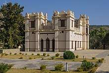
- Ethiopian Treasures - Emperor Yohannes IV Castle - Mekele
- Future Observatory - Dam Building in Tigray by David Mercer
- "Tigrayans want end to border row" by Elizabeth Blunt, BBC News, 20 December 2007
- Tigray: Then and Now - the son of Mohamed Amin covers sustainable agriculture in Tigray following the Horn of Africa drought in 2011.
Zones of the Tigray Region | ||
|---|---|---|
 | ||
Woredas of the Tigray Region | ||
|---|---|---|
| Central Tigray Zone | | |
| East Tigray Zone | ||
| North West Tigray Zone | ||
| South Tigray Zone | ||
| South East Tigray Zone | ||
| West Tigray Zone | ||
| Mek'ele Special Zone |
| |
Coordinates: 14°08′12″N 38°18′34″E / 14.1365757°N 38.3093262°E