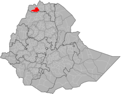
Welkait
| Welkait ወልቃይት | ||
|---|---|---|
| Woreda | ||
.jpg) | ||
| ||
 | ||
| Region | Tigray | |
| Zone | Mi'irabawi Zone (Western) | |
| Area | ||
| • Total | 3,374.52 km2 (1,302.91 sq mi) | |
| Population (2007) | ||
| • Total | 138,926 | |
Welkait (Tigrinya: ወልቃይት) is a woreda and region in northwestern Ethiopia, part of the West Zone of Tigray Region. The woreda is bordered to the north by Kafta Humera and to the south by Tsegede; these are the other two woredas of Mi'irabawi Zone in Tigray.[1] It is bordered on the east by the North West Zone; the woredas of Tahtay Adiyabo and Asgede Tsimbla lie to the north-east, on the other side of the Tekezé River, and Tselemti is to the east. The administrative center of Welkait is Addi Remets; other towns in the woreda include Mai'gaba and Awura.
Overview
Welkait is known for its fertile alluvial soil, which grows cash crops such sesame, cotton and also sorghum. Because this region has long and strong historical ties with Sudan, Tigray, Eritrea and Gonder, it has become a hot spot for all people from all the parts of Ethiopia and neighbouring countries.
Until the 1995 administrative reorganization, Welkait was part of Semien and Begemder provinces. Welkait was then split into two parts once ethnic federalism was established in Ethiopia. One of the two parts with an Amhara majority went to the new Amhara Region, the other (which kept the old name) had a majority of Tigrayans and was allocated within the Tigray Region.
Ever since the split there were ethnic tensions as Amhara people considered themselves the majority in Welkait (and asked to be moved to Amhara region) while the new Welkait woreda (which kept the original name) was smaller than the old Welkait and had a Tigrayan majority. These ethnic tensions around Welkait woreda played a decisive role during the 2016 Ethiopian protests.
Demographics
Based on the 2007 census conducted by the Central Statistical Agency of Ethiopia (CSA), this woreda has a total population of 138,926, an increase of 90,186 over the 1994 national census, of whom 70,504 are men and 68,422 women; 10,758 or 7.74% are urban inhabitants. With an area of 3,374.52 km2, Welkait has a population density of 41.17 people/km2, which is greater than the Zone average of 28.94 people/km2. A total of 30,375 households were counted in this woreda, resulting in an average of 4.57 persons in a household, and 29,336 housing units. The majority of the inhabitants said they practiced Ethiopian Orthodox Christianity, with 97.28% reporting that as their religion, while 2.71% of the population were Muslim.[2]
The 1994 national census reported a total population for this woreda of 90,186, of whom 45,657 were men and 44,529 were women; 4,597 or 5.1% of its population were urban dwellers. The two largest ethnic groups reported in Welkait were the Tigrayan (96.58%), and the Amhara (3.03%); all other ethnic groups made up only 0.39% of the population. Tigrinya is spoken as a first language by 97.14%, and 2.75% speak Amharic; the remaining 0.11% spoke all other primary languages reported. 96.75% of the population said they were Ethiopian Orthodox Christians, and 3.09% were Muslim. Concerning education, 3.9% of the population were considered literate, which is less than the Zone average of 9.01%; 3.36% of children aged 7–12 were in primary school, which is less than the Zone average of 11.34%; a negligible number of the children aged 13–14 were in junior secondary school, which is also less than the Zone average of 0.65%; and a negligible number of children aged 15–18 were in senior secondary school, which is less than the Zone average of 0.51%. Concerning sanitary conditions, about 1% of the urban houses and about 8% of all houses had access to safe drinking water at the time of the census; about 4% of the urban and about 4% of all houses had toilet facilities.[3]
Ethnicity
| Ethnic Group | 1994 Census[4] | 2007 Census*[5] |
|---|---|---|
| Tigrayan | 96.58% | 92.28% |
| Amhara | 3.03% | 6.48% |
| Kunama | - | 0.31% |
| Oromo | - | 0.35% |
| Eritreans | 0.21% | 0.03% |
| Afar | 0.02% | 0.02% |
| Agaw | 0.04% | 0.10% |
| Irob | - | 0.11% |
| Sudanese | 0.07% |
*Urban and Rural Mi'irabawi Zone statistics because none are available for Welkait specifically.
Mother Language
| Language | 1994 Census[6] | 2007 Census*[7] |
|---|---|---|
| Tigrinya | 97.14% | 86.73% |
| Amharic | 2.75% | 12.18% |
| Afaan Oromo | 0.01% | 0.33% |
| Kunama | - | 0.32% |
| Agaw | 0.06% | 0.09% |
*Urban and Rural Mi'irabawi Zone statistics because none are available for Welkait specifically.
Religion
| Religion | 1994 Census[8] | 2007 Census[9] |
|---|---|---|
| Orthodox Christian | 96.75% | 97.28% |
| Protestant | 0.03% | - |
| Muslim | 3.09% | 2.71% |
Economy
Agriculture
A sample enumeration performed by the CSA in 2001 interviewed 24,417 farmers in this woreda, who held an average of 0.99 hectares of land. Of the 24,286 hectares of private land surveyed, over 86.69% was in cultivation, 1.27% pasture, 10.37% fallow, 0.03% in woodland, and 1.65% was devoted to other uses. For the land under cultivation in this woreda, 63.29% was planted in cereals, 4.19% in pulses, 18.24% in oilseeds, and 0.17% in vegetables is missing. The area planted in gesho was 25 hectares; the area in fruit trees is missing. 79.64% of the farmers both raised crops and livestock, while 10.96% only grew crops and 9.4% only raised livestock. Land tenure in this woreda is distributed amongst 73.93% owning their land, 25.09% renting, and 0.98% reported as holding their land under other forms of tenure.[10] The intensive agriculture is necessary to feed people of the region due to the burgeoning human population, but continuing conversion of natural lands to agriculture is taking a toll on biodiversity in the area.
Sugar industry
The Ethiopian Sugar Corporation is building a sugar mill in Welkait region.[11]
Transportation
Ground Travel
In May 2010 construction was underway on a 98-kilometer road westwards from Adi Remets to Dejena Densha; construction of a road in the other direction, eastwards from Adi Remets to Dedebit in Asgede Tsimbla woreda, was awarded that month to Sur Construction for 801 million birr.[12]
References
- ↑ United Nations Office for the Coordination of Humanitarian Affairs (27 March 2013). "Ethiopia Administrative Map" (PDF). Relief Web. Retrieved 4 April 2018.
- ↑ Census 2007 Tables: Tigray Region, Tables 2.1, 2.4, 2.5 and 3.4.
- ↑ 1994 Population and Housing Census of Ethiopia: Results for Tigray Region, Vol. 1, part 1, Tables 2.1, 2.12, 2.19, 3.5, 3.7, 6.3, 6.11, 6.13 (accessed 30 December 2008)
- ↑ The 1994 Population and Housing Census of Ethiopia Results for Tigray Region. 1. Addis Ababa: Central Statistical Authority. 1995. p. 70.
- ↑ 2007 National Population and Housing Census. Addis Ababa: Central Statistical Authority. 2008. pp. 72–73.
- ↑ The 1994 Population and Housing Census of Ethiopia Results for Tigray Region. Addis Ababa: Ethiopian Statistical Agency. 1995. p. 82.
- ↑ 2007 National Population and Housing Census. Addis Ababa: Central Statistical Agency. 2008. pp. 86–87.
- ↑ 1994 Population and Housing Census Results for Tigray Region. 1. Addis Ababa: Central Statistical Agency. 1995. p. 98.
- ↑ 2007 National Housing and Population Census. Addis Ababa: Ethiopian Statistical Agency. 2008. p. 99.
- ↑ "Central Statistical Authority of Ethiopia. Agricultural Sample Survey (AgSE2001). Report on Area and Production - –Tigray (read Amhara) Region. Version 1.1 - December 2007" (accessed 26 January 2009)
- ↑ "Ethiopia injects US$4 billion into sugar factories". The Africa Report. 20 December 2011. Retrieved 15 October 2016.
- ↑ "Tigray, Southern towns get first roads", Addis Fortune 2 May 2010 (accessed 16 October 2016)