Abergele (woreda)
| Tanqua Abergele ጣንቁኣ ዓበርገለ | ||
|---|---|---|
| Woreda | ||
.jpg) | ||
| ||
 | ||
| Region | Tigray | |
| Zone | Mehakelegnaw (Central) | |
| Area | ||
| • Total | 2,407.88 km2 (929.69 sq mi) | |
| Population (2007) | ||
| • Total | 93,185 | |
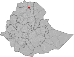
Tanqua Abergele (Tigrinya: ጣንቁኣ ዓበርገለ) is one of the woredas in the Tigray Region of Ethiopia. Part of the Mehakelegnaw Zone, Abergele is bordered on the south and west by the Amhara Region, then by the Tekezé River on the west which separates it from Amhara Region and the Semien Mi'irabawi (North Western) Zone, on the north by Kola Tembien, on the east by Degua Tembien and on the southeast by the Debub Misraqawi (South Eastern) Zone. The administrative center of this woreda is Yechila; other towns in Abergele include Agbe. Abergele is one of the low lying districts of central Tigray and the Tanqua River, which originates near Hagere Selam, flows through this woreda and joins the Geba just north of Jijike.
History
It was a constituent of the old Tembien awrajja.[1] Historically, Abergele seems to have formed a province since early times (perhaps the 14th century). It was governed by a shum in the reign of Lebna Dengel and Susenyos (16th-17th century). According to the chronicle of atse Yohannes I, the people of Abergele joined the rebellion, which was lead by Fares and Zayohannes and suppressed by abeto Dalbe Iyesus in 1678.[2]
Nowadays Abergele is bounded by Enderta in the east, Sekota in the south and qolla Tembien, in the northern and western directions. It assumes a unique position mainly for its trilinguistic makeup. Its inhabitants constitute the sole Agaw enclave in Tigray, but the majority speaks Tigrinya and some Amharic as well.[3] In terms of religion, however, they are predominantly adherents of Christianity. Very few of them practice Islam.
Agriculture forms the main stay of Abergele economic life. As elsewhere in most districts of Tembien, social services are hardly developed. The first schools and health centers of the calling are just emerging. This was partly attributed to the region's relative geographic remoteness from the center.[1] This seclusion and strategic position at the cross-roads of Wollo, Tigray, and Gondar, seemed to have made it a safe abode for political dissidents for over centuries.[4] It hoisted series of protracted armed encounters between the chiefs of these regions including that of Yejju.[5]
Demographics
Based on the 2007 national census conducted by the Central Statistical Agency of Ethiopia (CSA), this woreda has a total population of 93,185, except an increase of 59.64% over the 1994 census, of whom 47,512 are men and 45,673 women; 7,035 or 7.55% are urban inhabitants. With an area of 2,407.88 square kilometers, Abergele has a population density of 38.70, which is less than the Zone average of 56.29 persons per square kilometer. A total of 19,775 households were counted in this woreda, resulting in an average of 4.71 persons to a household, and 18,767 housing units. The majority of the inhabitants said they practiced Ethiopian Orthodox Christianity, with 98.91% reporting that as their religion.[6]
The 1994 national census reported a total population for this woreda of 58,373, of whom 29,541 were men and 28,832 were women; 2,334 or 4% of its population were urban dwellers. The two largest ethnic groups reported in Abergele were the Tigrayan (97.93%), and the Agaw Kamyr (1.82%); all other ethnic groups made up 0.25% of the population. Tigrinya was spoken as a first language by 98.17%, and 1.43% spoke Kamyr; the remaining 0.4% spoke all other primary languages reported. 99.83% of the population practiced Ethiopian Orthodox Christianity, and 0.12% were Muslim. Concerning education, 5.92% of the population were considered literate, which is less than the Zone average of 14.21%; 4.04% of children aged 7–12 were in primary school; a negligible number of the children aged 13–14 were in junior secondary school, and a negligible number of the inhabitants aged 15–18 were in senior secondary school. Concerning sanitary conditions, about 72% of the urban houses and 19% of all houses had access to safe drinking water at the time of the census; none of the urban and 1.6% of the total had toilet facilities.[7]
Agriculture
A sample enumeration performed by the CSA in 2001 interviewed 15,123 farmers in this woreda, who held an average of 1.63 hectares of land. Of the 24,690 hectares of private land surveyed, 87.36% was in cultivation, 0.21% pasture, 10.72% fallow, and 1.72% was devoted to other uses. For the land under cultivation in this woreda, 81.93% was planted in cereals, 2.34% in pulses, 2.92% in oilseeds, and 0.02% in vegetables. Four hectares were planted in fruit trees and 18 in gesho. 89.37% of the farmers both raised crops and livestock, while 10.15% only grew crops and 0.48% only raised livestock. Land tenure in this woreda is distributed amongst 84.81% owning their land, and 14.9% renting; the percentage reported as holding their land under other forms of tenure is missing.[8]
Surrounding woredas
Places adjacent to Abergele (woreda) | |
|---|---|
Notes
- 1 2 Igziabher, Taddesse Gabre (1972). Power Struggle in Tigray During Zamana Masafint. Addis Ababa: Haile Sellassie I University.
- ↑ Guidi, Ignazio (1903). Annales Iohannis I, Iyāsu I et Bakāffā. Paris: E Typographeo Reipublicae. p. 25.
- ↑ Rossini, Carlo Conti (1904). "Note sugli Agau: 1. Appunti sulla lingua khamta dell' Averghellé". Giornale della Società asiatica italiana. 17: 183–242.
- ↑ Huntingford, George Wynn Brereton (1989). The Historical Geography of Ethiopia: From the First Century AD to 1704. London: Union Académique Internationale.
- ↑ Berhe, Tsegay (1996). A History of Agame, 1822-1914. Addis Ababa: Addis Ababa University.
- ↑ Census 2007 Tables: Tigray Region Archived 2010-11-14 at the Wayback Machine., Tables 2.1, 2.4, 2.5 and 3.4.
- ↑ 1994 Population and Housing Census of Ethiopia: Results for Southern Nations, Nationalities and Peoples' Region, Vol. 1, part 1 Archived 2008-11-19 at the Wayback Machine., Tables 2.1, 2.12, 2.19, 3.5, 3.7, 6.3, 6.11, 6.13 (accessed 30 December 2008)
- ↑ "Central Statistical Authority of Ethiopia. Agricultural Sample Survey (AgSE2001). Report on Area and Production - Tigray Region. Version 1.1 - December 2007" Archived 2009-11-14 at the Wayback Machine. (accessed 26 January 2009)