List of Canadian provinces and territories by population

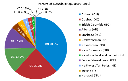
Canada is divided into ten provinces and three territories. The majority of Canada's population is concentrated in the areas close to the Canada–US border. Its four largest provinces by area (Quebec, Ontario, British Columbia and Alberta) are also (with Quebec and Ontario switched in order) its most populous; together they account for 86% of the country's population. The territories (the Northwest Territories, Nunavut and Yukon) account for over a third of Canada's area but are home to only 0.3% of its population, which skews the national population density value.
Canada's population grew by 5.0% between the 2006 and 2011 censuses.[1] Except for New Brunswick, all territories and provinces increased in population from 2011 to 2016. In terms of percent change, the fastest-growing province or territory was Nunavut with an increase of 12.7% between 2011 and 2016, followed by Alberta with 11.6% growth. New Brunswick's population decreased by 0.5% between 2011 and 2016.
Canada's population has increased every year since Confederation in 1867: see List of population of Canada by years.
Listing
| Rank | Name[1] | Population, 2016 Census |
Growth, 2011–16 |
Land area (km2) |
Population density (per km2) |
House of Commons seats |
2018 population (Q3 est.)[2] | |||
|---|---|---|---|---|---|---|---|---|---|---|
| Total | Proportion | Total | Proportion | Total | Proportion | |||||
| 1 | 13,448,494 | 38.3% | 4.6% | 908,699.33 | 14.8 | 121 | 35.8% | 14,322,757 | 38.7% | |
| 2 | 8,164,361 | 23.2% | 3.3% | 1,356,625.27 | 6.0 | 78 | 23.1% | 8,390,499 | 22.9% | |
| 3 | 4,648,055 | 13.2% | 5.6% | 922,503.01 | 5.0 | 42 | 12.4% | 4,991,687 | 13.1% | |
| 4 | 4,067,175 | 11.6% | 11.6% | 640,330.46 | 6.4 | 34 | 10.0% | 4,307,110 | 11.7% | |
| 5 | 1,278,365 | 3.6% | 5.8% | 552,370.99 | 2.3 | 14 | 4.1% | 1,352,154 | 3.6% | |
| 6 | 1,098,352 | 3.1% | 6.3% | 588,243.54 | 1.9 | 14 | 4.1% | 1,162,062 | 3.2% | |
| 7 | 923,598 | 2.6% | 0.2% | 52,942.27 | 17.4 | 11 | 3.3% | 959,942 | 2.6% | |
| 8 | 747,101 | 2.1% | −0.5% | 71,388.81 | 10.5 | 10 | 3.0% | 770,633 | 2.1% | |
| 9 | 519,716 | 1.5% | 1.0% | 370,514.08 | 1.4 | 7 | 2.1% | 525,355 | 1.4% | |
| 10 | 142,907 | 0.41% | 1.9% | 5,686.03 | 25.1 | 4 | 1.2% | 153,244 | 0.41% | |
| 11 | 41,786 | 0.12% | 0.8% | 1,143,793.86 | 0.04 | 1 | 0.3% | 44,541 | 0.12% | |
| 12 | 35,944 | 0.10% | 12.7% | 1,877,778.53 | 0.02 | 1 | 0.3% | 38,396 | 0.10% | |
| 13 | 35,874 | 0.10% | 5.8% | 474,712.68 | 0.08 | 1 | 0.3% | 40,476 | 0.10% | |
| Total | 35,151,728 | 100% | 5.0% | 8,965,588.85 | 3.9 | 338 | 100% | 37,058,856 | 100% | |
.png)
.svg.png)
See also
References
- 1 2 "Population and dwelling counts, for Canada, provinces and territories, 2016 and 2011 censuses – 100% data". Statistics Canada. February 8, 2017. Retrieved February 8, 2017.
- ↑ "Table 051-0005: Estimates of population, Canada, provinces and territories". Statistics Canada. September 27, 2018. Retrieved September 29, 2018.
| Provinces | |
|---|---|
| Territories | |
| Historical | |
| Related | |
| |
| Ranked | |
|---|---|
| Political | |
| Historical | |
| Other | |