Tankerton Slopes
| Site of Special Scientific Interest | |
 | |
| Area of Search | Kent |
|---|---|
| Grid reference | TR 121 672[1] |
| Interest | Biological |
| Area | 2.3 hectares (5.7 acres)[1] |
| Notification | 1986[1] |
| Location map | Magic Map |
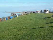
Tankerton Slopes is a 2.3-hectare (5.7-acre) biological Site of Special Scientific Interest in Whitstable in Kent.[1][2] It is part of the Tankerton Slopes and Swalecliffe Special Area of Conservation[3]
This north facing slope has a population of tall herbs, including the largest population in Britain of hog’s fennel, a nationally rare umbellifer. Fauna include agonopterix putridella, a nationally rare moth whose larvae feed exclusively on hog's fennel.[4]
There is access to the site from Tankerton Beach.
References
- 1 2 3 4 "Designated Sites View: Tankerton Slopes". Sites of Special Scientific Interest. Natural England. Retrieved 1 March 2018.
- ↑ "Map of Tankerton Slopes". Sites of Special Scientific Interest. Natural England. Retrieved 1 March 2018.
- ↑ "Designated Sites View: Tankerton Slopes and Swalecliffe". Special Area of Conservation. Natural England. Retrieved 22 January 2018.
- ↑ "Tankerton Slopes citation" (PDF). Sites of Special Scientific Interest. Natural England. Retrieved 1 March 2018.
| Wikimedia Commons has media related to Tankerton Slopes. |
This article is issued from
Wikipedia.
The text is licensed under Creative Commons - Attribution - Sharealike.
Additional terms may apply for the media files.