Lympne Escarpment
| Site of Special Scientific Interest | |
 | |
| Area of Search | Kent |
|---|---|
| Grid reference | TR 124 344[1] |
| Interest | Biological |
| Area | 140.2 hectares (346 acres)[1] |
| Notification | 1987[1] |
| Location map | Magic Map |
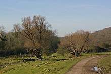
Lympne Escarpment is a 140.2-hectare (346-acre) biological Site of Special Scientific Interest west of Hythe in Kent.[1][2]Part of it is the remains of a Saxon Shore fort now called Stutfall Castle, which is a Scheduled Monument.[3]
This steeply sloping site has woodland and grassland on Kentish ragstone, with many springs and flushes at the base. It is close to the sea, and the resulting high humidity allows plants such as stinking iris, which are usually confined to woods, to grow in grassland.[4]
Public footpaths cross the site.
References
- 1 2 3 4 "Designated Sites View: Lympne Escarpment". Sites of Special Scientific Interest. Natural England. Retrieved 16 February 2018.
- ↑ "Map of Lympne Escarpment". Sites of Special Scientific Interest. Natural England. Retrieved 16 February 2018.
- ↑ "Saxon Shore fort now called Stutfall Castle, 468m south-west of St Stephen's Church". Historic England. Retrieved 16 February 2018.
- ↑ "Lympne Escarpment citation" (PDF). Sites of Special Scientific Interest. Natural England. Retrieved 16 February 2018.
| Wikimedia Commons has media related to Lympne Escarpment. |
This article is issued from
Wikipedia.
The text is licensed under Creative Commons - Attribution - Sharealike.
Additional terms may apply for the media files.