Robins Wood
| Site of Special Scientific Interest | |
 | |
| Area of Search | Kent |
|---|---|
| Grid reference | TQ 768 338[1] |
| Interest | Biological |
| Area | 47.7 hectares (118 acres)[1] |
| Notification | 1987[1] |
| Location map | Magic Map |
Robins Wood is a 47.7-hectare (118-acre) biological Site of Special Scientific Interest between Tunbridge Wells and Ashford in Kent.[1][2]
This is a deep valley along a stream in the Weald, and has the humid conditions typical of such areas. It has a diverse flora of mosses, ferns and liverworts, and woodland which is thought to date back to recolonisation after the last ice age ended 11,700 years ago.[3]
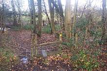
Footpaths go through some parts of the site.
References
- 1 2 3 4 "Designated Sites View: Robins Wood". Sites of Special Scientific Interest. Natural England. Retrieved 23 February 2018.
- ↑ "Map of Robins Wood". Sites of Special Scientific Interest. Natural England. Retrieved 23 February 2018.
- ↑ "Robins Wood citation" (PDF). Sites of Special Scientific Interest. Natural England. Retrieved 23 February 2018.
| Wikimedia Commons has media related to Robins Wood. |
This article is issued from
Wikipedia.
The text is licensed under Creative Commons - Attribution - Sharealike.
Additional terms may apply for the media files.