Oaken Wood
| Site of Special Scientific Interest | |
 | |
| Area of Search | Kent |
|---|---|
| Grid reference | TQ 701 548[1] |
| Interest | Geological |
| Area | 18.7 hectares (46 acres)[1] |
| Notification | 1985[1] |
| Location map | Magic Map |
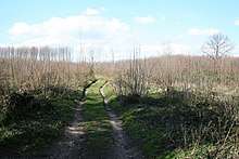
Oaken Wood is a 18.7-hectare (46-acre) geological Site of Special Scientific Interest west of Maidstone in Kent.[1][2] It is a Geological Conservation Review site.[3]
This site provides the best example of a very unusual topography, with cracking and tilting of underlying weaker strata during the Pleistocene by periglacial processes producing crests and troughs in the surface rocks.[4]
A public footpath crosses the site.
References
- 1 2 3 4 "Designated Sites View: Oaken Wood". Sites of Special Scientific Interest. Natural England. Retrieved 20 February 2018.
- ↑ "Map of Oaken Wood". Sites of Special Scientific Interest. Natural England. Retrieved 20 February 2018.
- ↑ "Oaken Wood (Quaternary of South-East England)". Geological Conservation Review. Joint Nature Conservation Committee. Archived from the original on 12 January 2018. Retrieved 11 January 2018.
- ↑ "Oaken Wood citation" (PDF). Sites of Special Scientific Interest. Natural England. Retrieved 20 February 2018.
| Wikimedia Commons has media related to Oaken Wood. |
This article is issued from
Wikipedia.
The text is licensed under Creative Commons - Attribution - Sharealike.
Additional terms may apply for the media files.