Souk Ahras Province
| Souk Ahras Province ولاية سوق أهراس | |
|---|---|
 | |
 Map of Algeria highlighting Souk Ahras | |
| Coordinates: 36°23′N 8°00′E / 36.383°N 8.000°ECoordinates: 36°23′N 8°00′E / 36.383°N 8.000°E | |
| Country |
|
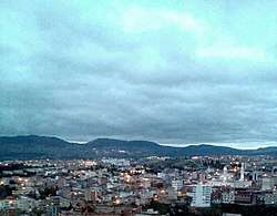
| Capital | Souk Ahras |
| Area | |
| • Total | 4,541 km2 (1,753 sq mi) |
| Population (2008)[1] | |
| • Total | 440,299 |
| • Density | 97/km2 (250/sq mi) |
| Time zone | UTC+01 (CET) |
| Area Code | +213 (0) 37 |
| ISO 3166 code | DZ-41 |
| Districts | 10 |
| Municipalities | 26 |
Souk Ahras (Arabic: ولاية سوق أهراس) is a province (wilaya) in the Aures region in Algeria, named after its capital, Souk Ahras. It stands on the border between Algeria and Tunisia.
Geography
Souk Ahras is situated in the extreme north east of Algeria. Its area is 4360 km². Its border to the north is the province of El Taref; in the east is Tunisia; westward is the province of Guelma and the province of Oum el Bouaghi; in the south the province of Tebessa Souk Ahras has a population of 450,000 people.
Relief
It is composed of three important areas:
- In the north: mountainous region.
- In the south: agricultural area.
- In the centre: lowlands region.
Climate
The city of Souk Ahras has a semi continental and humid climate, heavy rains in the north in winter and very hot and dry in the south during summer. The rains are 350-750 mm/year and the temperatures vary from 1°C to 14°C in winter and from 25°C to 38°C in summer.
The fauna is very rich in Souk Ahras, where species such as the hare, partridge, fox, sparrow, ferret, porcupine and barbarian hart can be found. The flora as well is very rich, with species such as:
- Cork oak: 12,000 hectares
- Zeen oak: 4,600 hectares
- Ash-tree
- Flowering ash
- Aleppo pine (Pinus halepensis)
- Cypress tree
- Mastic-tree
- Lavender
- Heather
Trading activities
Trading activities are widespread in Sedrata and Zaarouria were many public and private companies have been set up:
- National company of painting
- National company of textile
- Brick-making company
- Sedrata metallic company
- Mansouri paper factory
- Hamada dairy
- ALKALAM factory
Agriculture
The most important activities in this region are: agriculture, breeding and com cultivation. The total area is about 436,000 hectares. 235,000 hectares are consecrated to agriculture.
Infrastructure
Basic under structures and the railway system:
Main roads: 600 km Secondary roads: 1600 km. The railway from Souk Ahras to Annaba is 138.8 km, among which 100 km are electrified.
Administrative divisions
The province is divided into 10 districts (daïras), which are further divided into 26 communes or municipalities.
Districts
Communes

References
- ↑ Office National des Statistiques, Recensement General de la Population et de l’Habitat 2008 Preliminary results of the 2008 population census. Accessed on 2008-07-02.
Capital: Souk Ahras | ||
| Districts | 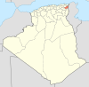 | |
| Communes | ||
| ||