Talkeetna Airstrip
|
Talkeetna Airstrip | |
|
Alaska Heritage Resources Survey
| |
 | |
 | |
| Location | Along D Street, from East First Street to the Susitna River, Talkeetna, Alaska |
|---|---|
| Coordinates | 62°19′12″N 150°06′48″W / 62.31997°N 150.11333°WCoordinates: 62°19′12″N 150°06′48″W / 62.31997°N 150.11333°W |
| Area | 19.95 acres (8.07 ha) |
| Built | 1940 |
| Built by | Civilian Aeronautics Administration |
| NRHP reference # | 02000814[1] |
| AHRS # | TAL-038 |
| Added to NRHP | August 2, 2002 |
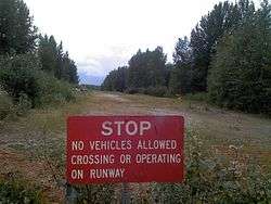
The Talkeetna Airstrip is a historic runway in Talkeetna, Alaska. It is a rectangular area of land, covered by grass and gravel, extending southward along D Street from First Street toward the Susitna River. It is about 1,800 feet (550 m) long and 30 feet (9.1 m) wide, with its northern stretch now lined with private residences and its southern stretch surrounded by public woodlands. The airstrip was created in 1940 as the result of a presidential executive order issued by President Franklin Delano Roosevelt in 1937, which set aside federal land near Talkeetna for aviation-related purposes. It played a major role in the economic development of the community, as air transport was the most reliable method of bringing supplies and travelers into the area.[2]
The airstrip was listed on the National Register of Historic Places in 2002,[1] at which time it was still occasionally used for aviation.[2] Most aviation now uses the state-owned Talkeetna Airport, located east of the village center.
See also
References
- 1 2 National Park Service (2010-07-09). "National Register Information System". National Register of Historic Places. National Park Service.
- 1 2 "NRHP nomination for Talkeetna Airstrip". National Park Service. Retrieved 2015-01-07.
 | Boroughs | .svg.png) | |
Census areas | |||
There are no sites listed on the National Register of Historic Places in Kusilvak Census Area. | |||
| Topics | |
|---|---|
| Lists by states |
|
| Lists by insular areas | |
| Lists by associated states | |
| Other areas | |
| |