T'Boli, South Cotabato
| T'Boli | |
|---|---|
| Municipality | |
| Municipality of T'Boli | |
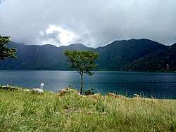 Lake Holon in the Municipality of T'boli | |
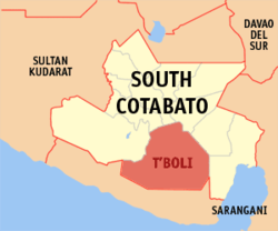 Map of South Cotabato with T'Boli highlighted | |
.svg.png) T'Boli Location within the Philippines | |
| Coordinates: 6°13′N 124°49′E / 6.22°N 124.82°ECoordinates: 6°13′N 124°49′E / 6.22°N 124.82°E | |
| Country |
|
| Region | Soccsksargen (Region XII) |
| Province | South Cotabato |
| District | 2nd District |
| Barangays | 25 (see Barangays) |
| Government [1] | |
| • Type | Sangguniang Bayan |
| • Mayor | Dibu S. Tuan |
| • Electorate | 46,075 voters (2016) |
| Area [2] | |
| • Total | 895.83 km2 (345.88 sq mi) |
| Population (2015 census)[3] | |
| • Total | 91,453 |
| • Density | 100/km2 (260/sq mi) |
| Demonym(s) | Tboli |
| Time zone | UTC+8 (PST) |
| ZIP code | 9513 |
| PSGC | 126316000 |
| IDD : area code | +63 (0)83 |
| Climate type | Tropical rainforest climate |
| Income class | 1st municipal income class |
| Revenue (₱) | 258,752,205.68 (2016) |
| Native languages | Hiligaynon, Tboli, Ilocano, Cebuano, Tagalog |
| Website |
central |
T'Boli, officially the Municipality of T'Boli, is a 1st class municipality in the province of South Cotabato, Philippines. According to the 2015 census, it has a population of 91,453 people.[3] The town is named after the indigenous natives themselves, the Tboli people.
Located in the town is Lake Holon within Mount Parker. The lake was declared as the cleanest inland body of water in the entire country in 2003 and 2004.[4]
Barangays
T'boli is politically subdivided into 25 barangays.
Demographics
| Population census of T'Boli | ||
|---|---|---|
| Year | Pop. | ±% p.a. |
| 1975 | 32,602 | — |
| 1980 | 39,412 | +3.87% |
| 1990 | 26,346 | −3.95% |
| 1995 | 54,206 | +14.47% |
| 2000 | 60,693 | +2.45% |
| 2007 | 70,609 | +2.11% |
| 2010 | 79,175 | +4.25% |
| 2015 | 91,453 | +2.78% |
| Source: Philippine Statistics Authority[3][5][6][7] | ||
References
- ↑ "Municipality". Quezon City, Philippines: Department of the Interior and Local Government. Retrieved 31 May 2013.
- ↑ "Province: South Cotabato". PSGC Interactive. Quezon City, Philippines: Philippine Statistics Authority. Retrieved 12 November 2016.
- 1 2 3 Census of Population (2015). "Region XII (Soccsksargen)". Total Population by Province, City, Municipality and Barangay. PSA. Retrieved 20 June 2016.
- ↑ https://lifestyle.mb.com.ph/2017/01/06/south-cotabatos-lake-holon-closed-to-visitors-for-rehab/ South Cotabato’s Lake Holon closed to visitors for rehab – Manila Bulletin]
- ↑ Census of Population and Housing (2010). "Region XII (Soccsksargen)". Total Population by Province, City, Municipality and Barangay. NSO. Retrieved 29 June 2016.
- ↑ Censuses of Population (1903–2007). "Region XII (Soccsksargen)". Table 1. Population Enumerated in Various Censuses by Province/Highly Urbanized City: 1903 to 2007. NSO.
- ↑ "Province of South Cotabato". Municipality Population Data. Local Water Utilities Administration Research Division. Retrieved 17 December 2016.
External links
Places adjacent to T'Boli, South Cotabato | |
|---|---|
Koronadal (capital) | |
| Municipalities | |
| Component City | |
| Highly Urbanized City |
|
This article is issued from
Wikipedia.
The text is licensed under Creative Commons - Attribution - Sharealike.
Additional terms may apply for the media files.