Surif
| Surif | |
|---|---|
| Other transcription(s) | |
| • Arabic | صوريف |
 Pastoral scene near Surif village | |
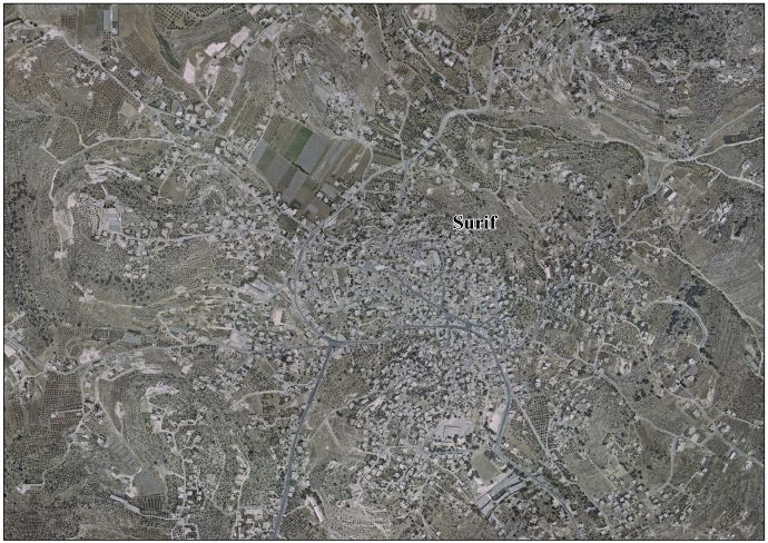
 Surif Location of Surif within Palestine | |
| Coordinates: 31°39′02″N 35°03′58″E / 31.65056°N 35.06611°ECoordinates: 31°39′02″N 35°03′58″E / 31.65056°N 35.06611°E | |
| Palestine grid | 156/117 |
| Governorate | Hebron |
| Government | |
| • Type | City |
| • Head of Municipality | Ahmad Lafi |
| Area | |
| • Jurisdiction | 15,034 dunams (15.0 km2 or 5.8 sq mi) |
| Population (2007) | |
| • Jurisdiction | 13,365 |
| Name meaning | from personal name[1] |
Surif (Arabic: صوريف) is a Palestinian City in the Hebron Governorate located 25 km northwest of the city of Hebron. According to the Palestinian Central Bureau of Statistics census, Surif had a population of 17,650 in 2016.[2] The population is entirely Muslim.
Most of the town's 15,000 dunams is used for agriculture, in particular, olives, wheat and barley.[3] There are seven mosques and four schools located in its vicinity.
Ahmad Lafi is the mayor.[4]
History
In 1838 Surif was noted as a Muslim village, located between Hebron and Gaza, but subjected to the government of Hebron.[5]
In 1863 Victor Guérin found Surif to be a village with 700 inhabitants. He further noted that beside a birket in the rock, a few cisterns and an ancient column shaft which was placed near a small mosque, all of Surif's constructions seemed more or less modern.[6]
An official Ottoman village list from about 1870 showed 87 houses and a population of 265, counting men only.[7][8]
In 1883, the Palestine Exploration Fund's Survey of Western Palestine described Surif as "A small village on a low hill, with olives to the south."[9]
In 1896 the population of Surif was estimated to be about 1164 persons.[10]
British Mandate Era
According to the 1922 census of Palestine conducted by the British Mandate authorities, Surif had a population of 1,265 inhabitants, all Muslims,[11] increasing in the 1931 census to 1,640, in 344 inhabited houses.[12]
In the 1945 statistics the population of Surif was 2,190, all Muslims,[13] with a total of 38,876 dunams of land according to an official land and population survey.[14] Of this, 3,493 dunams were plantations and irrigable land, 11.325 for cereals,[15] while 54 dunams were built-up (urban) land.[16]
Jordanian era
In the wake of the 1948 Arab–Israeli War and the 1949 Armistice Agreements, As-Samu came under Jordanian rule.
The Jordanian census of 1961 found 2,827 inhabitants in Surif.[17]
Post-1967
After the Six-Day War in 1967, Surif has been under Israeli occupation.
Israel has confiscated approximately 1,213 dunams of land from Surif since 2000, and approximately 1,300 dunums of Surif lands will behind the segregation wall, when it is finished.[18]
References
- ↑ Palmer, 1881, p. 408
- ↑ 'Localities in Hebron Governorate by Type of Locality and Population Estimates, 2007-2016 ,' Palestinian Central Bureau of Statistics, 2016.
- ↑ The Segregation Separation Wall hits the lands of Surif and Khibet Ad Deir- Hebron district Land Research Center 2004-10-24
- ↑ Huge new Israeli settlement in West Bank condemned by US and UK
- ↑ Robinson and Smith, 1841, vol 3, Appendix 2, p. 117
- ↑ Guérin, 1869, pp. 381-382
- ↑ Socin, 1879, p. 161
- ↑ Hartmann, 1883, p. 143 noted 100 houses
- ↑ They further noted: this may perhaps be the early Christian Sariphsea mentioned in connection with Mar Saba and Beit Jibrin. See: Conder and Kitchener, 1883, SWP III, p. 309
- ↑ Schick, 1896, p. 122
- ↑ Barron, 1923, p. 10
- ↑ Mills, 1932, p. 33
- ↑ Government of Palestine, Department of Statistics, 1945, p. 23
- ↑ Government of Palestine, Department of Statistics. Village Statistics, April, 1945. Quoted in Hadawi, 1970, p. 50 Archived 2009-07-20 at WebCite
- ↑ Government of Palestine, Department of Statistics. Village Statistics, April, 1945. Quoted in Hadawi, 1970, p. 94
- ↑ Government of Palestine, Department of Statistics. Village Statistics, April, 1945. Quoted in Hadawi, 1970, p. 144
- ↑ Government of Jordan, Department of Statistics, 1964, p. 14
- ↑ Surif Town Profile, ARIJ, 2006, p. 14
Bibliography
- Barron, J.B., ed. (1923). Palestine: Report and General Abstracts of the Census of 1922. Government of Palestine.
- Conder, C.R.; Kitchener, H.H. (1883). The Survey of Western Palestine: Memoirs of the Topography, Orography, Hydrography, and Archaeology. 3. London: Committee of the Palestine Exploration Fund.
- Government of Jordan, Department of Statistics (1964). First Census of Population and Housing. Volume I: Final Tables; General Characteristics of the Population (PDF).
- Government of Palestine, Department of Statistics (1945). Village Statistics, April, 1945.
- Guérin, V. (1869). Description Géographique Historique et Archéologique de la Palestine (in French). 1: Judee, pt. 3. Paris: L'Imprimerie Nationale.
- Hadawi, S. (1970). Village Statistics of 1945: A Classification of Land and Area ownership in Palestine. Palestine Liberation Organization Research Center.
- Hartmann, M. (1883). "Die Ortschaftenliste des Liwa Jerusalem in dem türkischen Staatskalender für Syrien auf das Jahr 1288 der Flucht (1871)". Zeitschrift des Deutschen Palästina-Vereins. 6: 102–149.
- Mills, E., ed. (1932). Census of Palestine 1931. Population of Villages, Towns and Administrative Areas. Jerusalem: Government of Palestine.
- Palmer, E.H. (1881). The Survey of Western Palestine: Arabic and English Name Lists Collected During the Survey by Lieutenants Conder and Kitchener, R. E. Transliterated and Explained by E.H. Palmer. Committee of the Palestine Exploration Fund.
- Robinson, E.; Smith, E. (1841). Biblical Researches in Palestine, Mount Sinai and Arabia Petraea: A Journal of Travels in the year 1838. 3. Boston: Crocker & Brewster.
- Schick, C. (1896). "Zur Einwohnerzahl des Bezirks Jerusalem". Zeitschrift des Deutschen Palästina-Vereins. 19: 120–127.
- Socin, A. (1879). "Alphabetisches Verzeichniss von Ortschaften des Paschalik Jerusalem". Zeitschrift des Deutschen Palästina-Vereins. 2: 135–163.
External links
- Welcome To Surif
- Surif, Welcome to Palestine
- Survey of Western Palestine, Map 21: IAA, Wikimedia commons
- Surif Town (Fact Sheet), Applied Research Institute–Jerusalem, ARIJ
- Surif Town Profile, ARIJ
- Surif aerial photo, ARIJ
- The priorities and needs for development in Surif town based on the community and local authorities’ assessment, ARIJ
| Cities |
|  |
|---|---|---|
| Towns |
| |
| Villages |
| |
| Refugee camps | ||