Khirbet al-Deir
| Khirbet al-Deir | |
|---|---|
| Other transcription(s) | |
| • Arabic | خربة الدير |
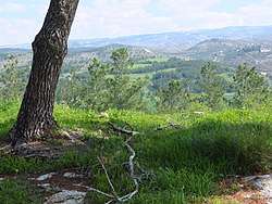 Idyllic scene overlooking the Arab village, Khirbet al-Deir | |
 Khirbet al-Deir Location of Khirbet al-Deir within Palestine | |
| Coordinates: 31°39′20″N 35°01′30″E / 31.65556°N 35.02500°ECoordinates: 31°39′20″N 35°01′30″E / 31.65556°N 35.02500°E | |
| Palestine grid | 152/117 |
| Governorate | Hebron |
| Government | |
| • Type | Village council |
| Population (2007) | |
| • Jurisdiction | 264 |
| Name meaning | "Ruin of the monastery"[1] |
Khirbet al-Deir (Arabic: خربة الدير), or Khirbet ed-Deir, is a Palestinian village located 10 kilometres (6.2 mi) southwest of Bethlehem, and 15 kilometres (9.3 mi) northwest of Hebron. The town is in the Hebron Governorate of central West Bank. According to the 2007 Palestinian Central Bureau of Statistics (PCBS) Census, the village had a population of 264 people.[2]
History
Conder briefly mentioned the site of the village ed-Deir, saying that he found there traces of ruins, and fragments of tesselated pavement, which belonged formerly to an old monastery, in addition to two wells lined with masonry.[3]
The modern village was built upon the ruins of the old village and still bears its old namesake. The modern village was established in the early 18th-century, by residents who broke away from Surif.[4]
1967-present
Since the Six-Day War in 1967, the town has been under Israeli occupation, although in 1993, under the interim Oslo Peace Accords, areas of the West Bank which Israel conquered in the 1967 Mideast war were divided into various administrative categories, governed by the Palestinian Authority. The only institution in the village is the Village Council. The population in the 1967 census conducted by the Israeli authorities was 301.[5] According to statistics provided by ARIJ, in 2009, some 40% of the village's population made-up the Israeli labor market, being issued permits to work on the Israeli-side of the Green Line.[6] The villagers are all Muslims.
The villagers are considered well-to-do, having built for themselves spacious houses and villas.
Another village by the same name, but larger, is in the Bethlehem Governorate, part of Tuqu'.
Footnotes
- ↑ Palmer, 1881, p. 6.
- ↑ Khirbet Ad Deir Village Profile, ARIJ, p. 4
- ↑ Conder and Kitchener, 1883, SWP III, p. 327.
- ↑ Khirbet Ad Deir Village Profile (The Applied Research Institute - Jerusalem), p. 5
- ↑ Perlmann, Joel (November 2011 – February 2012). "The 1967 Census of the West Bank and Gaza Strip: A Digitized Version" (PDF). Levy Economics Institute. Retrieved 24 June 2016.
- ↑ Khirbet Ad Deir Village (Fact Sheet), ARIJ
Bibliography
- Conder, C.R.; Kitchener, H.H. (1883). The Survey of Western Palestine: Memoirs of the Topography, Orography, Hydrography, and Archaeology. 3. London: Committee of the Palestine Exploration Fund.
- Palmer, E.H. (1881). The Survey of Western Palestine: Arabic and English Name Lists Collected During the Survey by Lieutenants Conder and Kitchener, R. E. Transliterated and Explained by E.H. Palmer. Committee of the Palestine Exploration Fund.
External links
- Welcome To Kh. al-Dayr
- Khirbet Ad Deir Village (Fact Sheet), Applied Research Institute–Jerusalem, ARIJ
- Khirbet Ad Deir Village Profile, ARIJ
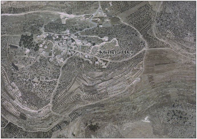
- Aerial photo, ARIJ
- The priorities and needs for development in Khirbet ad Deir village based on the community and local authorities’ assessment, ARIJ
- Survey of Western Palestine, Map 21: IAA, Wikimedia commons
| Cities |
|  |
|---|---|---|
| Towns |
| |
| Villages |
| |
| Refugee camps | ||