Sullivan Square station
SULLIVAN SQUARE | |||||||||||
|---|---|---|---|---|---|---|---|---|---|---|---|
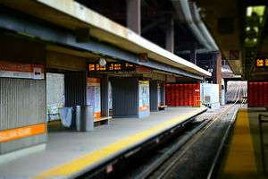 Sullivan Square, facing inbound; supports for elevated highway are visible at top center | |||||||||||
| Location |
One Broadway at One Cambridge Street Charlestown, Boston, Massachusetts | ||||||||||
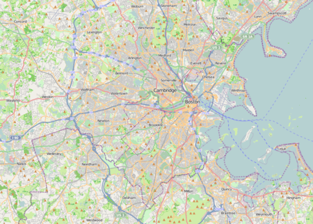
| Coordinates | 42°23′03″N 71°04′37″W / 42.384031°N 71.07697°WCoordinates: 42°23′03″N 71°04′37″W / 42.384031°N 71.07697°W | ||||||||||
| Owned by | Massachusetts Bay Transportation Authority | ||||||||||
| Line(s) | |||||||||||
| Platforms | 2 island platforms (Orange Line) | ||||||||||
| Tracks |
3 (Orange Line) 2 (commuter rail) | ||||||||||
| Construction | |||||||||||
| Parking |
222 spaces ($6.00 fee) 7 accessible spaces | ||||||||||
| Bicycle facilities | 16 spaces | ||||||||||
| Disabled access | Yes | ||||||||||
| History | |||||||||||
| Opened | June 10, 1901 (elevated station) | ||||||||||
| Rebuilt | April 7, 1975 (modern station)[1] | ||||||||||
| Traffic | |||||||||||
| Passengers (2011) | 10,125 (weekday average boardings)[2] | ||||||||||
| Services | |||||||||||
| |||||||||||
| Location | |||||||||||
   | |||||||||||
Sullivan Square is a rapid transit station in Boston, Massachusetts. It serves the MBTA's Orange Line, and is also a major bus transfer point. It is located just west of the Sullivan Square traffic circle in the Charlestown neighborhood, adjacent to East Somerville. The modern subway station was built in 1975, and replaced an earlier Charlestown Elevated station established in 1901.
History
Sullivan Square and its station are named for James Sullivan, an early 19th-century Governor of Massachusetts[3] and first president of the Middlesex Canal Co. A plaque commemorating the canal is on the column right of the entrance to the station.
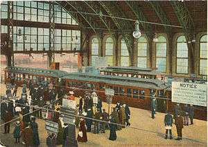
The first station at Sullivan Square opened on June 10, 1901 as part of the Charlestown Elevated rapid transit line, a predecessor to the modern Orange Line. The elevated Sullivan Square station was a major transfer point in the system until it closed in 1975 to make way for the modern Orange Line.[4]
The modern station opened opened April 7, 1975 as part of the Haymarket North Extension. The station has three tracks and two platforms, and is located under a double-decked elevated section of Interstate 93.[5]
Station layout
| L2 Platforms |
Southbound | ← Orange Line toward Forest Hills (Community College) |
| Island platform, doors will open on the left, right | ||
| Northbound | → Orange Line toward Oak Grove (Assembly)→ | |
| Island platform, doors will open on the right | ||
| Northbound | → No regular service | |
| L1 Concourse |
Lobby | Fare barriers |
| G | Street level | Exit |
History
Sullivan Square stands on what was once a narrow neck of land referred to as the Charlestown Neck, an area that was originally a thin strip of land connecting the Charlestown Peninsula with present-day East Somerville.[6] Being in a narrow place between larger land masses made Sullivan Square a place where transportation routes naturally converged, and various transportation facilities developed here over the years.
Of particular note was the construction of the Middlesex Canal which spanned 27 miles from Lowell to terminate at the Mill Pond in Charlestown, passing directly through where the Sullivan Square traffic circle stands today. Completed in 1803, the canal was considered a major engineering feat at its time. However, the Boston and Lowell Railroad, completed in 1835, captured much of the freight business, and the canal ceased operation by 1853.
The Boston and Lowell and the Fitchburg, the earliest railroads to pass through Somerville, did not come through this area of the city, but in 1842 the Boston and Maine Corporation opened a station near Sullivan Square. This led to the construction of a residential enclave for commuters to Boston. New streets were laid out, such as Mt. Vernon Street and Mt. Pleasant Street, and small lots were plotted out along them.[7]
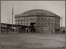
The next transportation revolution to make its way through Sullivan Square was the streetcar. Horsecars connecting Somerville to Charlestown and Boston started running in 1858, just two years after the first horsecar in Massachusetts connected Cambridge and Boston. Horsecar travel continued to grow until the early 1890s, when electrically powered street railways became popular. Sullivan Square came to be the location of a large carhouse, and in 1901 a grand new station was built to serve both streetcars and the Boston Elevated Railway, the new rapid transit line connecting Sullivan Square and Dudley Square by way of downtown Boston.
The B&M's East Somerville station building was closed in 1927; in February 1932, with just a few trains a day stopping, the railroad petitioned the Public Utilities Commission to abandon the station entirely.[8] However, the station remained in use, served by a small number of trains on both the Eastern Division and Western Division.[9] On April 18, 1958, the Boston and Maine Railroad received permission from the Public Utilities Commission to drastically curtail its suburban commuter service, including abandoning branches, closing stations, and cutting trains. Among the approved cuts was the closure of all Eastern Division service south of Lynn, including the Saugus Branch plus mainline stations at East Somerville, Everett, Chelsea, and Forbes.[10] The Saugus Branch and mainline stations were closed on May 16, 1958.[11][12]
The original elevated station was considered a crown jewel of the "El", along with a similar station complex at Dudley Square in Roxbury. Surface streetcars ran up to 10 stub-end tracks at the level of the elevated stations, allowing cross-platform transfer underneath an expansive trainshed.[13]:21 The station was designed as a major transfer point, with many streetcar lines that had gone downtown truncated to Sullivan.
However, the station quickly reached capacity, and a northward extension to Everett opened in 1919. Later, beginning in 1963, the Everett terminus was closed nights and Sundays, and the truncated routes (now all buses) were extended back to Sullivan Square at those times.[14]
Over time, deferred maintenance on the Charlestown Elevated and Sullivan Square station took its toll. A large fire also caused significant damage to the station's upper level on November 1, 1967.[15] The Haymarket North Extension was constructed in the early 1970s along the Haverhill Line right-of-way, with a relocated new Sullivan Square station under the elevated I-93 expressway. The Charlestown Elevated closed on April 4, 1975; the Haymarket North Extension opened as far as Sullivan Square on April 7. The new Sullivan station was the terminus of the extension for five months until Wellington opened on September 6, 1975.[1]
There were proposals to renovate the cavernous old trainshed for use as retail or gallery spaces, but no such conversion took place; the massive structure was subsequently razed in 1975[16] and repurposed as an MBTA service vehicle parking lot.[17] Only supports for a footbridge crossing the traffic circle remain of the elevated station. A similar structure at the Dudley Square station on the Orange Line was carefully preserved, lowered to ground level, and reopened in 1993 as a major bus transfer station.
Bus connections

Sullivan Square has long been a major transfer point for surface transit. The original elevated station had surface and elevated streetcar loops to serve a number of BERy and Eastern Massachusetts Street Railway lines. The modern station has a two-level busway that serves 12 MBTA bus routes to Medford, Everett, Malden and other surrounding cities:
- 86 Sullivan Square Station - Reservoir (Cleveland Circle) via Harvard/Johnston Gate
- 89 Clarendon Hill or Davis Square - Sullivan Square Station via Broadway
- 90 Davis Square - Wellington Station via Sullivan Square Station & Assembly Square Mall
- 91 Sullivan Square Station - Central Square, Cambridge via Washington Street
- 92 Assembly Square Mall - Downtown via Sullivan Square Station, Main Street & Haymarket Station
- 93 Sullivan Square Station - Downtown via Bunker Hill Street & Haymarket Station
- 95 West Medford - Sullivan Square Station via Mystic Avenue
- 101 Malden Center Station - Sullivan Square Station via Salem Street, Main Street & Broadway
- 104 Malden Center Station - Sullivan Square Station via Ferry Street & Broadway
- 105 Malden Center Station - Sullivan Square Station via Newland Street Housing
- 109 Linden Square - Sullivan Square Station via Glendale Square
- CT2 Sullivan Square - Ruggles Station via Kendall/MIT
Plans
Sullivan Square Station is a proposed stop on the MBTA's planned Urban Ring Project.[18] The Urban Ring would be a circumferential Bus Rapid Transit (BRT) line designed to connect the current MBTA Lines to reduce strain on the downtown transfer stations. Plans from 2008 also called for the addition of platforms to serve the adjacent Haverhill and Newburyport/Rockport commuter rail lines.[19]
References
- 1 2 Belcher, Jonathan (22 March 2014). "Changes to Transit Service in the MBTA district" (PDF). NETransit. Retrieved 26 May 2014.
- ↑ "Ridership and Service Statistics" (PDF) (14th ed.). Massachusetts Bay Transportation Authority. 2014.
- ↑ "James Sullivan (1744-1808)". mass.gov. James Sullivan (1744-1808). 2013. Retrieved 6 December 2013.
- ↑ "Sullivan Square". Boston Streetcars. Retrieved 6 December 2013.
- ↑ City of Boston Department of Transportation. "Rutherford Avenue / Sullivan Square Design Project". cityofboston.gov/. City of Boston. Retrieved 6 December 2013.
- ↑ cf. Haskell, Albert L., "Haskell's Historical Guide Book of Somerville, Massachusetts", section on "Somerville: Why So Named".
- ↑ "Sullivan Square: Part 1 of 3". Somerville Development Forum. Somerville Development Forum. Retrieved 6 December 2013.
- ↑ "B. & M. WANTS TO ABANDON STATIONS: One at East Somervile in List of Three". Daily Boston Globe. 12 February 1932 – via Proquest Historical Newspapers. (Subscription required (help)).
- ↑ Form 5: Haverhill - Lawrence - Boston (timetable), Boston and Maine Railroad, July 8, 1956
- ↑ "Drastic Service Cuts Approved on Five B.& M. Divisions". Daily Boston Globe. 19 April 1958. p. 11 – via Proquest Historical Newspaper. (Subscription required (help)).
- ↑ Humphrey, Thomas J.; Clark, Norton D. (1985). Boston's Commuter Rail: The First 150 Years. Boston Street Railway Association. p. 77. ISBN 9780685412947.
- ↑ "B.&M. Closes Saugus Branch, 3 Other Lines". Daily Boston Globe. 17 May 1958. p. 3 – via Proquest Historical Newspapers. (Subscription required (help)).
- ↑ Cudahy, Brian J. (1972). Change at Park Street Under: The Story of Boston's Subways. Brattleboro, Vermont, US: Stephen Greene Press. ISBN 0-8289-0173-2.
- ↑ "Boston Elevated Railway Company, Main Line Elevated Structure (HAER)". NYCsubway.org. NYC Subway. Retrieved 6 December 2013.
- ↑ "This Time in History". Rollsign. Vol. 54 no. 11/12. Boston Street Railway Association. November–December 2017. p. 15.
- ↑ "Main Line Elevated Photos". CelebrateBoston. CelebrateBoston.com. Retrieved 2016-02-16.
- ↑ "Sullivan Square: Part 3 of 3". Somerville Development Forum. Somerville Development Forum. Retrieved 6 December 2013.
- ↑ Urban Ring Phase 2 Archived 2011-07-08 at the Wayback Machine.. Massachusetts Executive Office of Transportation.
- ↑ Urban Ring Phase 2 Plan Profile Drawings. Massachusetts Executive Office of Transportation.
External links
| Wikimedia Commons has media related to Sullivan Square station. |
- MBTA - Sullivan Square
- nycsubway.org - MBTA Orange Line: Sullivan Square
- nycsubway.org - MBTA Orange Line: Sullivan Square (Demolished)