Strzelecki Creek
| Strzelecki | |
| Creek | |
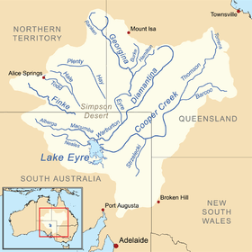 A map of the Lake Eyre Basin showing the location of Strzelecki Creek | |
| Name origin: Paul Edmund de Strzelecki | |
| Country | Australia |
|---|---|
| State | South Australia |
| Region | Far North |
| Municipality | unincorporated area |
| Part of | Lake Eyre Basin |
| Source | Cooper Creek |
| - location | south of Innamincka |
| - elevation | 52 m (171 ft) |
| Mouth | Lake Blanche |
| - location | west of Montecollina |
| - elevation | 1 m (3 ft) |
| - coordinates | 29°21′51″S 139°49′49″E / 29.364260°S 139.830150°ECoordinates: 29°21′51″S 139°49′49″E / 29.364260°S 139.830150°E |
| Length | 200 km (124 mi) |
| protected areas | Strzelecki Regional Reserve |
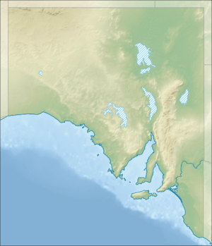 Location of the river mouth in South Australia | |
| [1] | |
The Strzelecki Creek, part of the Lake Eyre basin, is an ephemeral watercourse located in the Australian state of South Australia.
Course and features
The Strzelecki is a distributary of Cooper Creek and branches off near the town of Innamincka and flows in a southerly direction thought the Strzelecki Desert for about 200 kilometres (120 mi) towards Lake Blanche. While being feed by the Cooper Creek, it does have its own catchment and can flow independently after ‘heavy localised storms.’ Flows on ‘exceptional’ occasions can reach Lakes Blanche, Callabonna, Frome and Gregory. Its watercourse is lined by trees, bordered by “large parallel sand ridges” and includes “a series of waterholes.” [2][3][4]
Parts of the creek system are within the protected area known as the Strzelecki Regional Reserve. The creek system is also within the boundaries of the non-statutory Strzelecki Desert Lakes Important Bird Area .[5] The former pastoral lease property Tinga Tingana straddled the creek which also passes through Blanchewater Station.
Etymology
It was named by the British explorer, Charles Sturt in 18 August 1845 after Paul Edmund de Strzelecki, the Polish scientist and explorer.[2][4] Explorer Augustus Charles Gregory and his party found that following Strzelecki Creek proved to be the best way to travel through the interior from the Pacific to the Southern Ocean.[6]
See also
References
- ↑ "Map of Strzelecki Creek, SA". Bonzle Digital Atlas of Australia. Retrieved 23 March 2017.
- 1 2 "Search result for " Strzelecki Creek (Stream) (Record no. SA0049990) with the following layers selected - "Suburbs and Localities" and "Place names (gazetteer)"". Property Location Browser. Government of South Australia. Retrieved 26 September 2016.
- ↑ Morton, S. R; Barker, R. D. (Robin Dale), 1940-; Doherty, M. D; CSIRO. Division of Wildlife and Ecology; Australia. World Heritage Unit (1995), Natural heritage values of the Lake Eyre Basin in South Australia : world heritage assessment (PDF), CSIRO Division of Wildlife and Ecology, p. 42, retrieved 26 September 2016
- 1 2 South Australia. Department for Environment and Heritage (2002), A review of Lake Frome and Strzelecki Regional Reserves, 1991-2001 (PDF), Dept. for Environment and Heritage, pp. 11 and 15, ISBN 978-0-7590-1038-3
- ↑ "Important Bird Areas factsheet: Strzelecki Desert Lakes". BirdLife International. 2017. Retrieved 31 March 2017.
- ↑ "Strzelecki Creek National Heritage Place, Strzelecki Tk, Innamincka, SA, Australia". Australian Heritage Database. 2014. Retrieved 26 August 2014.