Innamincka, South Australia
| Innamincka South Australia | |||||||||
|---|---|---|---|---|---|---|---|---|---|
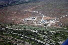 Innamincka from the north-east | |||||||||
 Innamincka | |||||||||
| Coordinates | 27°44′S 140°44′E / 27.733°S 140.733°ECoordinates: 27°44′S 140°44′E / 27.733°S 140.733°E | ||||||||
| Population | 12 (2016 census)[1] | ||||||||
| Established | 1890, 1972 | ||||||||
| Postcode(s) | 5731 | ||||||||
| Elevation | 57 m (187 ft) | ||||||||
| Time zone | ACST (UTC+9:30) | ||||||||
| • Summer (DST) | ACDT (UTC+10:30) | ||||||||
| Location | 821 km (510 mi) NE of Adelaide | ||||||||
| LGA(s) | Outback Communities Authority | ||||||||
| Region | Far North | ||||||||
| State electorate(s) | Stuart[2] | ||||||||
| Federal Division(s) | Grey[3] | ||||||||
| |||||||||

Innamincka is a small settlement in north-east South Australia, with a population of only 12. It is 821 kilometres north-east of Adelaide and 365 kilometres north-east from the closest town, Lyndhurst. It is also 66 kilometres north-east of the Moomba Gas Refinery. The town lies within the Innamincka Regional Reserve and is surrounded by the Strzlecki Desert to the south and the Sturt Stony Desert to the north. The township is situated along the Cooper Creek, a part of the Lake Eyre Basin.[1]
History
The area was the traditional home of the Yandruwandha, Aborigines. The first European to visit the area was Charles Sturt in 1845.[4] He was followed by A C Gregory in 1858 and then Burke and Wills. A monument to Sturt and Burke and Wills was erected in Innamincka in 1944.
In 1882 a police camp was set up that allowed a small settlement to develop.[4] Commencing 7 April 1889, a Royal Mail coach ran fortnightly from Farina, operated by merchants Davey and Pilkington.[5] Originally called Hopetoun, Innamincka was proclaimed a township in 1890. Hopetoun was named after the Governor of Victoria, the Earl of Hopetoun but it was never popular with locals.[4] The town was never very large, but had a hotel, a store and a police station which, until Federation in 1901, acted as the customs post for collecting duties on cattle brought overland from Queensland into South Australia. In 1928 the Australian Inland Mission (a part of the Royal Flying Doctor Service of Australia) built a hospital here, the Elizabeth Symon Nursing Home. Severe drought and poor access to the settlement resulted in the closure of the hotel and the hospital. In 1951 the police post closed and the town was abandoned.
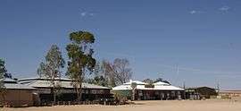
Increased tourism and discovery of gas and oil reserves in the late 1960s led to the formation of Cooper Creek Hotel Motel Pty Ltd, which opened a hotel, a store and accommodation in the abandoned town. In 1994 the Elizabeth Symon Nursing Home was restored by Dick Smith and Australian Geographic and was used as an interpretive centre for South Australian Parks and Wildlife. The nursing home had been listed on the South Australian Heritage Register on 25 July 1985.[6]
Today the town has a population of about 15. The town common, on the banks of the Cooper, is popular with campers, as is the town's public coin-in-slot toilet and shower facility.
Gray's Tree, the supposed burial place of a member of the Burke and Wills expedition, is listed on the South Australian Heritage Register and located in the north-western rural area of the Innamincka locality.[7][8][9]
Burke and Wills
The Burke and Wills expedition passed through this area on their journey across Australia from Melbourne to the Gulf of Carpentaria. They established a Depot Camp on Cooper Creek at Camp LXV, (their sixty-fifth camp since leaving Melbourne), at a place now called The Dig Tree. There was a depot at the Dig Tree from 6 December 1860 to 21 April 1861.
The Victorian Contingent Party under Alfred Howitt was sent by the Victorian government to establish the fate of the expedition. Howitt found the remains of both leaders, Robert O'Hara Burke and William John Wills and buried them close to where the town is located today. He also found the sole survivor, John King living amongst and cared for by the Yandruwandha aboriginals, and returned him to Melbourne.
Howitt returned to the area in 1862 as leader of the Victorian Exploring Party. He established a depot camp at Cullyamurra Waterhole before exhuming the bodies of Burke and Wills and transporting them to Melbourne for a State Funeral.
Today it is possible to visit the locations of Wills' grave and King's site on Cooper Creek downstream of Innamincka, and Burke's grave, Howitt's camp and the Dig Tree on Cooper Creek upstream of Innamincka.
References
- 1 2 Australian Bureau of Statistics (25 October 2007). "Innamincka (State Suburb)". 2006 Census QuickStats. Retrieved 2 August 2011.
- ↑ "District of Stuart Background Profile". Electoral Commission SA. Retrieved 30 September 2015.
- ↑ "Federal electoral division of Grey, boundary gazetted 16 December 2011" (PDF). Australian Electoral Commission. Retrieved 20 August 2015.
- 1 2 3 "Innamincka - South Australia - Australia - Travel". theage.com.au. The Age Company. 8 February 2004. Retrieved 2009-09-17.
- ↑ Advertiser, 3 April 1889, p 7.
- ↑ "Regional Reserve Headquarters (former Australian Inland Mission [AIM] Elizabeth Symon Nursing Home), Innamincka Regional Reserve". South Australian Heritage Register. Department of Environment, Water and Natural Resources. Retrieved 13 February 2016.
- ↑ "Tree, possibly marking the burial site of Charles Gray, member of Burke & Wills' 1861 expedition', Lake Massacre, Innamincka Regional Reserve". South Australian Heritage Register. Department of Environment, Water and Natural Resources. Archived from the original on 5 March 2016. Retrieved 12 February 2016.
- ↑ "Stuarts Creek, 5720". Location SA Map Viewer. Government of South Australia. Retrieved 16 February 2016.
- ↑ "Innamincka, 5731". Location SA Map Viewer. Government of South Australia. Retrieved 16 February 2016.