Patawalonga River
| Patawalonga | |
| Patawalonga Creek | |
| River | |
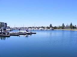 The Patawalonga River near its mouth | |
| Nickname: The Pat | |
| Country | Australia |
|---|---|
| State | South Australia |
| Region | Metropolitan Adelaide |
| District | Cowandilla Plains |
| Towns | Glenelg |
| Source | |
| - location | near Adelaide Airport |
| Mouth | Gulf St Vincent |
| - location | Glenelg North |
| - elevation | 0 m (0 ft) |
| - coordinates | 34°58′12″S 138°30′49″E / 34.9700°S 138.5136°ECoordinates: 34°58′12″S 138°30′49″E / 34.9700°S 138.5136°E |
| Length | 7 km (4 mi) |
| Basin | 210 km2 (81 sq mi) |
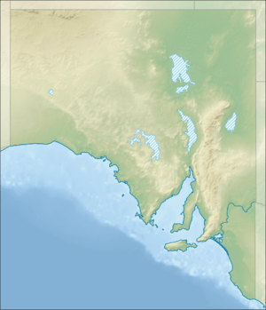 Location of the river mouth in South Australia | |
The Patawalonga River is a river located in the western suburbs of the Adelaide metropolitan area, in the Australian state of South Australia. It drains an area of flat, swampy lands formerly known as the Cowandilla Plains,[1] which in the mid-20th century were drained by engineering works, enabling the establishment of Adelaide Airport and the development of residential housing.
Course and features
The Patawalonga River, sometimes called Patawalonga Creek, and known to local residents as the Pat, is a short river of roughly 7 kilometres (4.3 mi) in length that was, before European settlement, a tidal estuary. The river is serviced by a 210-square-kilometre (81 sq mi) catchment area that exists in metropolitan Adelaide, with its mouth at the suburb of Glenelg.
The Patawalonga serves as an outlet for the Keswick and Brownhill creeks and the Sturt River (also known as Sturt Creek), the latter being a former natural creek comprising for a significant part of its length now as a large concrete storm-drain.
The catchment includes the Cowandilla-Mile End drainage network, the construction of which has replaced numerous small natural watercourses and swamp lands south of the Torrens River watershed. This area includes the suburb of Brooklyn Park and the southern parts of Torrensville, Underdale and Lockleys as well as Cowandilla, Mile End and Adelaide Airport. The construction of the airport from the late 1940s to 1954 included the present-day Cowandilla-Mile End Drain on the north boundary of the airport. It is called Airport Drain as it passes along the western edge of the airport and enters the Patawalonga at multiple points in the suburb of West Beach.[2][3]
The catchment also includes the Warriparinga Wetlands, opened 16 December 1998, an artificial wetlands situated near the suburb of Marion designed to filter stormwater before it flows through the Sturt River to the Patawalonga.
At its mouth the river's flow is regulated by barrages at Glenelg North and then flows past the Holdfast Shores marina development.
Damming
The first advocate for damming the Patawalonga was Thomas King MP, who introduced a Bill into the State Parliament to enable the Corporation of Glenelg to construct such a dam in 1876. Damming, apart from enabling the Patawalonga to be navigable and thus a safe harbour for yachts and other recreational watercraft, was seen as a means of reducing or removing the odour from the estuary of the river. The dam was ultimately constructed in ca. 1885. King's service to his community is commemorated by a street and formerly by a bridge over the river connecting Glenelg North with Glenelg. The original "King Street Bridge", built in 1951, was found to be affected by concrete cancer in the late 1990s and was replaced by a new bridge in 2011, and renamed the "Michael Herbert Bridge".[4][5][6]
The weir has not precluded the need to continually dredge the outlet for boating craft to pass. A disagreement between the State Government and ferry operator Australian Ferries over the frequency dredging of sand and seaweed at the Patawalonga entrance led to the cancellation of the high-speed ferry service (featuring the Superflyte and, later, Enigma III vessels) between Glenelg and Kangaroo Island and Edithburgh on the Yorke Peninsula. The service had operated during summers from 1994 to November 2007.[7][8]
Water quality
The Patawalonga is probably best known for its notorious odour, which has been a problem for the "Pat" ever since European settlement since the mid-19th century. The odour arises from seaweed that grows in the shallow depths of the river estuary and, in more recent times, due to stormwater pollution.
Dredging of the outlet beyond the weir to remove sand and seaweed build-up would at times cause the seaweed to float back to shore and rot on the beach, causing a stench.[9]
Also, if too much fresh water flows into the Patawalonga it can kill off saltwater species of fish that exist in the lake - which, again, can result in an unpleasant odour,[10][11][12] An event like this occurred on the weekend of 22–23 January 2005, and was reported on the front page of the Adelaide Advertiser as follows:
Residents woke yesterday to an "awful" stench and the sight of hundreds of seagulls converging on the area in a feeding frenzy.
Barcoo Outlet
From the 1970s onwards, increasing levels of rubbish and dirty stormwater would collect in front of the weir in the Patawalonga, bringing the notorious stench and unsightly view of debris in the water at Glenelg North. The debris and pollution had rendered the Patawalonga unusable for recreational activities such as a popular local "milk-carton" rowing regatta, which ended - along with all other recreational use such as swimming, water skiing, sailboarding and dragon boat racing[13] - when local authorities closed the Patawalonga for such activities in 1987 due to concerns about public health due to pollution levels.[14]
Then Premier Dean Brown commissioned a review in 1995 and the then Environment Minister David Wotton promised to swim in the Patawalonga with the Premier within a year, as this was the estimated time-frame for cleaning up "the Pat".[15]
Six years later, in December 2001 the Barcoo Outlet was completed. The Outlet's intention was primarily to enable dirty stormwater from the catchment to be diverted away from the Patawonga Lake at an ultimate cost of approximately A$30m. The Outlet consists of an 885-metre (2,904 ft) pipeline diverting stormwater out of the final length of the Patawalonga and out to sea. Symbolically, the then Premier John Olsen took a media-attended swim in the Patawalonga as the State Government lifted the ban on recreational use.[15][16]
The Outlet project was initially dogged with controversy, due to failures to handle stormwater and pollution of Adelaide's beaches. People north of the Outlet (which itself is 500m north of the Patawalonga's natural mouth) at West Beach complained that the coastal drift was seeing the pollution simply shifted to their beaches instead of into the Patawalonga Lake. The Outlet also failed to handle stormwater during heavy rainfall and the resulting in stormwater pollution entered the lake section of the Patawalonga in April (2x),[17][18] May[19] and August 2002.[20] Another failure in the Outlet in February 2003 resulted in minor flooding and consequent damage to homes in both Glenelg North and upstream Novar Gardens.[21]
The lower section of the Patawalonga at Glenelg North is now more-or less operated as a lake, with seawater at times circulated in through the river mouth and then out through the Barcoo Outlet to the north. The Outlet is named after the frigate HMAS Barcoo, which ran aground at Glenelg North during a violent storm on 11 April 1948, which also destroyed most of the jetty at Glenelg.
Flood of 2003
Heavy rainfall and a malfunction in the weir resulted in the Patawalonga breaking its banks at Glenelg North on Friday, 27 June 2003 and flooding the homes of local residents.[22] The situation became a major political issue with the Premier, Mike Rann, declaring that he would establish a compensation fund for victims who had suffered water damage to their homes. A local newspaper report suggested that 160 homes were affected and the cause of the flooding was the gates to the weir being kept closed during a stormwater flood to protect yachts harboured in the Patawalonga Lake.[23] 145 residents made 150 claims upon the fund and at least A$1.4m was paid to the victims, ultimately, by weir operator Baulderstone Hornibrook.[24] A class action was later launched by 70 residents for further compensation for 'stress and inconvenience'.[25]
Etymology
'Patawalonga', literally from the indigenous local Kaurna language, is derived from 'Pattawilya + -ngga', the component parts being: Patta, which means a swamp gum tree (Eucalyptus ovata) and wilya meaning a branch while -ngga is a suffix used to indicate that the name is a location, patta-wilya-ngga the place of the branches of the swamp gum. A reference in the Manning Index of South Australian History [26] suggests another meaning was "swamp of snakes" whilst another historian suggests it was a name given by an Indigenous Australian crew member of Colonel Light's ship meaning "boggy and bushy stretch, with fish".[27]
In addition to names given above, the river was originally officially known as the "River Thames" and sometimes locally as the "Glenelg Creek". "River Thames" was the original name given in Light's 1836 city plan. Although the plan was approved by Governor Gawler the Indigenous name remained in common usage. Gawler encouraged colonists to collect information on Indigenous place names and he is known to have reinstated several Kaurna names in Adelaide.
European discovery
The State Library of South Australia records that Colonel Light, sailing in a vessel called the Rapid, discovered the Patawalonga River when sailing by and observing a river mouth when surveying the site for the city of Adelaide, via journal entry on 4 October 1836.[28]
The river mouth served as the first significant river port for the colony of South Australia, with the Port River at Port Adelaide comprising a shallow, mangrove river impassable - at that time - to large ships.
One historian records:[27]
The first boat constructed in the Patawalonga was the 22 ton cutter O.G. for the Colonial Secretary, Osmond Gilles. On the day it was launched in 1839, the boat was stranded until high tide. There was only 4 feet of water over the sand bar at the entrance.
Ships of over 300 tons, which were too big to enter Port Adelaide, discharged their passengers and cargoes at Glenelg. Floatable goods were pitched overboard and tided into the creek to the Customs House. The Customs House and flagstaff were erected in November 1839 for the accommodation of the Customs Officer and the crew of the two landing waiters. Pilots fees were still being collected on the Pat. fishing fleet of 35 vessels and for the landing of mail from the steamers until the 1880's. At that time it was called Port Glenelg.
HMS Buffalo
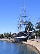
Perhaps the most iconic aspect of the Patawalonga River is the permanent mooring there of a replica of the HMS Buffalo, which made the six-month voyage carrying the first 400 settlers to South Australia in 1836. The original Buffalo had also carried Captain Hindmarsh, captain of that vessel and, upon his arrival, the first Governor of South Australia. The Buffalo replica has served[29][30] as a family and a la carte restaurant floating on the Patawalonga.[31]
See also
References
- ↑ Holmes, J.W. & Iversen, M.B.(1976): Hydrology of the Cowandilla Plains, Adelaide, before 1836. In: Twidale, C.R., Tyler, M.J. & Webb, B.P. (Eds) Natural History of the Adelaide Region. Royal Society of South Australia Inc. ISBN 0 9596627 3 1
- ↑ "Chapter 8: Services and Infrastructures" (PDF), Adelaide Airport 2014 Master Plan, p. 154, 9 January 2015, retrieved 10 January 2018
- ↑ "Chapter 10: Environment Strategy" (PDF), Adelaide Airport 2014 Master Plan, p. 196, 9 January 2015, retrieved 10 January 2018,
Adelaide Airport is bounded to the north by the Cowandilla-Mile End Drain, to the west by the Airport Drain and to the east and south by Brownhill-Keswick Creek. The Cowandilla-Mile End and Brownhill-Keswick catchments are highly urbanised and all drain into the Patawalonga Lake before entering Gulf St Vincent. An internal drainage network is present and directs the majority of stormwater into the Airport Drain, which similarly discharges to the Patawalonga Lake.
- ↑ Locals hail end to King St Bridge saga, Guardian Messenger, 14 December 2011.
- ↑ Michael Herbert Bridge, South Australia GHD. Retrieved 26 April 2017.
- ↑ Michael Patrick John HERBERT RSL Virtual War memorial. Retrieved 26 April 2017.
- ↑ Messenger newspaper, 2 December 1998, p1
- ↑ Adelaide Advertiser, 25 December 1998, p9
- ↑ Sunday Mail newspaper, 24 January 1999, p19
- ↑ Adelaide Advertiser, 24 January 2005, p1
- ↑ Adelaide Advertiser, 25 January 2005, p15
- ↑ Adelaide Advertiser, 1 June 2005, p10
- ↑ Messenger newspaper, 18 August 1999, p1
- ↑ Adelaide Advertiser, 18 February 2002, p12
- 1 2 Adelaide Advertiser, 17 December 2001, p11
- ↑ Adelaide Advertiser, 18 February 2002, p12
- ↑ Adelaide Advertiser, 2 April 2002, p15
- ↑ Adelaide Advertiser, 26 April 2002, p11
- ↑ Adelaide Advertiser, 24 May 2002, p21
- ↑ Adelaide Advertiser, 3 August 2002, p13
- ↑ Adelaide Advertiser, 21 February 2003, p5
- ↑ The Weekend Australian, 28 June 2003, p4
- ↑ Adelaide Advertiser, 26 November 2003, p1
- ↑ Adelaide Advertiser, 5 August 2004, p4
- ↑ Adelaide Advertiser, 26 June 2006, page 11
- ↑ "Place Names of South Australia - P, Patawalonga". State Library of South Australia. Retrieved 16 November 2007.
- 1 2 Crilly, K. "Patawalonga & The Reedbeds, Holdfast Bay". historysouthaustralia.net. Retrieved 16 November 2007.
- ↑ Light, William (1836). "A brief journal of the proceedings of William Light". State Library of South Australia. p. 12.
- ↑ "The Buffalo replica ship, Wigley Reserve, Glenelg". Holdfast Bay Council. Retrieved 11 March 2015.
- ↑ Stokes, John (6 February 2014). "Sale of Glenelg North's Buffalo Restaurant lodged with Holdfast Bay Council". Guardian Messenger. Retrieved 6 February 2014.
- ↑ "HMS Buffalo "The Historic ship in the Bay at Glenelg"". Buffalo Restaurant. Retrieved 19 November 2007.
Further reading
- South Australian Government Department of Water, Land, Biodiversity and Conservation (DWLBC) website concerning the Patawalonga
- The DWLBC site also contains live indications of levels of the Patawalonga
- Friends of Patawalonga Creek website describing the Creek