Streymoy
| Streymoy Strømø | |
|---|---|
| Island | |
.jpg) Skælingur (767 m) on Streymoy | |
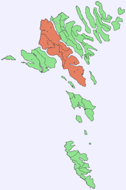 Location within the Faroe Islands | |
| Coordinates: 62°08′N 7°01′W / 62.133°N 7.017°WCoordinates: 62°08′N 7°01′W / 62.133°N 7.017°W | |
| State | Kingdom of Denmark |
| Constituent country | Faroe Islands |
| Region | Streymoy |
| Area | |
| • Total | 373 km2 (144 sq mi) |
| Area rank | 1 |
| Population (7-2017) | |
| • Total | 23,693[1] |
| • Rank | 1 |
| Time zone | UTC+0 (GMT) |
| • Summer (DST) | UTC+1 (EST) |
| Calling code | 298 |
Streymoy (Danish: Strømø) is the largest and most populated island of the Faroe Islands. The capital, Tórshavn, is located on its southeast coast. The name means "island of currents". It also refers to the largest region of the country that also includes the islands of Hestur, Koltur and Nólsoy.
Geography
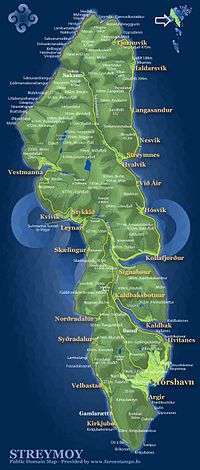
The island is oblong in shape and stretches roughly in northwest-southeast direction with a length of 47 kilometres (29 miles) and a width of around 10 kilometres (6 miles). There are two deeply-indented fjords in the southeast: Kollafjørður and Kaldbaksfjørður. The island is mountainous, especially in the northwest, with the highest peak being Kopsenni (789 metres (2,589 ft)).[2] That area is dominated by over 500-metre-high (1,640 ft) cliffs. The area is known as Vestmannabjørgini, which means Cliffs of Vestmanna.
Like the rest of the Faroe Islands there are numerous short streams and minor lakes. The main vegetation is grass, with no trees. Some of the villages have planted trees inside or just outside the village. These parks need to have fences around them in order to keep sheep out.
Streymoy is separated from the nearby Eysturoy to the east, the second-largest island of the Faroe Islands, by the narrow sound of Sundini. To the west lies the island of Vágar, and to the south the island of Sandoy. Three additional smaller islands are situated around the southern tip of Streymoy: Koltur, Hestur and Nólsoy.
Important bird area
The north-east coastline of the island has been identified as an Important Bird Area by BirdLife International because of its significance as a breeding site for seabirds, especially northern fulmars (75,000 pairs), European storm petrels (2500 pairs), European shags (150 pairs), great skuas (120 pairs), black-legged kittiwakes (9000 pairs), Atlantic puffins (20,000 pairs) and black guillemots (300 pairs).[3]
Population
There are about 23,693 inhabitants[1] on the island (7-2017), which represents more than 45% of the whole population of the Faroe Islands. The majority of them reside in the capital Tórshavn which has a population of about 21,000 in the municipality, of which 13,089 live in Tórshavn, 3,956 in Hoyvík and 2,110 in Argir, Hoyvík and Argir are suburbs of Tórshavn, but they have grown together. Around 1,202 people live in Vestmanna, 789 in Kollafjørður.[1] Besides being the seat of the government Tórshavn is also the chief port, seat of the university and the commercial centre of the islands.
Towns and villages
The other important towns include: Vestmanna, the former ferry port in the west, Kollafjørður at the centre and the picturesque villages of Saksun and Tjørnuvík in the north. From a historic point of view the village of Kirkjubøur near the southern tip of the island is very important as it was an episcopal center during the Middle Ages.
Transportation
All the settlements are connected by surfaced roads. The main entry road to Tórshavn passes through a 2.8 kilometres (1.7 mi) long tunnel. The connection to the island Eysturoy is via Streymin Bridge over the Sundini sound. Since 2002, the almost 5 kilometres (3.1 mi) long Vágar Tunnel has connected Streymoy to Vágar, thereby completing the road connections of the three "mainland" islands.[4]
Streymoy is connected by regular ferry service to the island of Sandoy from the ferry port on Gamla Rætt near Kirkjubøur, and to the islands Suðuroy and Nólsoy from the ferry port in Tórshavn.[5] In summertime, a scheduled ferry connects Tórshavn with Hanstholm in Denmark and Seyðisfjörður in Iceland; the remainder of the year the ferry connects with Esbjerg in Denmark.[6] The closest airport is on Vágar island; it is the only airport in the Faroe Islands.
Gallery
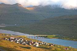 The Streymin bridge over Sundini Sound connects Eysturoy (this side) to Streymoy (distant side).
.jpg) The capital Tórshavn is on Streymoy.
The capital Tórshavn is on Streymoy.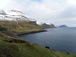 West coast of Streymoy.
.JPG) Mountain scenery near Saksun.
Mountain scenery near Saksun._north_of_T%C3%B3rshavn.jpg) The central highlands of Streymoy in winter.
The central highlands of Streymoy in winter.
References
- 1 2 3 Statistical Database
- ↑ "US.fo". Archived from the original on 15 July 2015. Retrieved 25 June 2017.
- ↑ BirdLife International. (2012). Important Bird Areas factsheet: Streymoy. Downloaded from http://www.birdlife.org on 2012-02-24.
- ↑ "Heim". Tunnil. Retrieved 25 June 2017.
- ↑ "Heim". SSL. Retrieved 25 June 2017.
- ↑ "Smyril Line - Sail to Iceland and the Faroe Islands hide". www.smyrilline.com. Retrieved 25 June 2017.
External links


- Tórshavn and Streymoy Tourist Information
Islands of the Faroe Islands | ||
|---|---|---|
Faroe Islands articles | |||||||
|---|---|---|---|---|---|---|---|
| |||||||
| History |  | ||||||
| Geography |
| ||||||
| Politics | |||||||
| Economy |
| ||||||
| Society |
| ||||||
| |||||||