Saksun
| Saksun | |
|---|---|
| Village | |
.JPG) View of Saksun from the lake | |
 Saksun Location in the Faroe Islands | |
| Coordinates: 62°14′56″N 7°10′33″W / 62.24889°N 7.17583°WCoordinates: 62°14′56″N 7°10′33″W / 62.24889°N 7.17583°W | |
| State |
|
| Constituent country |
|
| Island | Streymoy |
| Municipality | Sunda Municipality |
| Population (1 January 2006) | |
| • Total | 8 |
| Time zone | GMT |
| • Summer (DST) | UTC+1 (EST) |
| Postal code | FO 436 |
| Climate | ET |
Saksun (Danish: Saksen) is a village near the northwest coast of the Faroese island of Streymoy, in Sunda Municipality.
Geography
Saksun lies in the bottom of what used to be an inlet of the sea, surrounded by high mountains. The inlet formed a good deep natural harbour, until a storm blocked it with sand. The old harbour become an unaccessible seawater lagoon, only accessible by small boats on high tide.
Facilities
The village has a church and museum. The church was originally built in Tjørnuvík, but in 1858 it was disassembled, carried over the mountains and reassembled in Saksun. The Museum occupies a seventeenth-century farm house called Dúvugarður. The house belongs to the Dúvugarður farm, still an active sheep farm with approximately 710 ewes.
Gallery
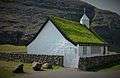 Church.
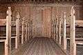 Interior of church
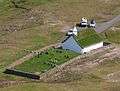 Church
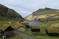 The old farm
 Saksun, Postverk Føroya
.JPG) Down to the beach
Down to the beach Saksun
 West coast
.JPG) Beach
Beach
See also
External links
- Faroeislands.dk: Saksun Images and description of all cities on the Faroe Islands.
| Wikimedia Commons has media related to Saksun. |
This article is issued from
Wikipedia.
The text is licensed under Creative Commons - Attribution - Sharealike.
Additional terms may apply for the media files.