Vestmanna
- Not to be confused with Vestmannaeyjar.
| Vestmanna Vestmannahavn | |
|---|---|
| Municipality and village | |
.JPG) Vestmanna in 2002 | |
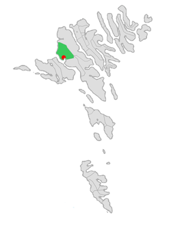 Location of Vestmanna kommuna in the Faroe Islands | |
 Vestmanna Location of Vestmanna village in the Faroe Islands | |
| Coordinates: 62°09′23″N 7°09′59″W / 62.15639°N 7.16639°WCoordinates: 62°09′23″N 7°09′59″W / 62.15639°N 7.16639°W | |
| State |
|
| Constituent country |
|
| Island | Streymoy |
| Population (January 1, 2017) | |
| • Total | 1,201[1] |
| Time zone | GMT |
| • Summer (DST) | UTC+1 (WEST) |
| Postal code | FO 350 |
| Climate | Cfc |
Vestmanna (Danish: Vestmannahavn) is a town in the Faroe Islands on the west of the island of Streymoy.
It was formerly a ferry port, until an undersea tunnel, the Vágatunnilin, was built from Vágar to Kvívík and Stykkið further south on Streymoy. The cliffs west of Vestmanna, Vestmannabjørgini, are very popular for excursions by boat.
A 'Vestmann' was a "Westman", or Gael in Old Norse. The original name was Vestmannahavn, i.e. "Westmen's/Irishmen's harbour".
History
In December 1759, during the Seven Years' War, François Thurot's squadron sheltered from stormy conditions at Vestmanna. The lack of supplies available from the islanders motivated the subsequent raids by the squadron on the north Irish coast.
Geography
It is surrounded by the mountains of Hægstafjall (296 m or 971 ft), Økslin (317 m or 1,040 ft), Loysingafjall (639 m or 2,096 ft), Moskurfjall (624 m or 2,047 ft).
.JPG)
Tourism
Vestmanna is often called the tourist village on the Faroe Islands. The main tourist attraction is Vestmannabjørgini. In 2012 a camping site was established at Inni á Fjørð with a capacity of 120 caravans in addition to tents.
Photos from Vestmannabjørgini and Vestmanna
.JPG) Boat trip to Vestmannabjørgini (Cliffs of Vestmanna).
Boat trip to Vestmannabjørgini (Cliffs of Vestmanna)..JPG) Vestmannabjørgini (Cliffs of Vestmanna).
Vestmannabjørgini (Cliffs of Vestmanna)..JPG) A Sea Stack West of Vestmanna.
A Sea Stack West of Vestmanna. The Viking Wax-museum in Vestmanna.
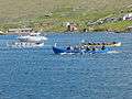 Fjarðastevna Cup 2012 in Vestmanna (kappróður)
 VÍF is the sports club from Vestmanna. Here they play handball in yellow and blue.
External links
- Vestmanna.fo, Municipality of Vestmanna
- Sightseeing.fo
- Puffin.fo
- Visit-vestmanna.com
| Wikimedia Commons has media related to Vestmanna. |
See also
Municipalities of the Faroe Islands | ||
|---|---|---|
 | ||